
Introduction
Geography is an important part of Uttar Pradesh-specific General Studies for the UPPCS examination. Questions may cover the geographical location of the state, physical regions, rivers, climate, soil, agriculture, natural resources, forests, wildlife and map-based facts.
These Uttar Pradesh Geography for UPPCS notes provide a structured revision guide for aspirants preparing for UPPCS Prelims and other state-level competitive examinations. This article includes important geographical facts, river systems, regional characteristics, map-based revision points and 50 practice MCQs with answers and brief explanations at the end.
This Uttar Pradesh Geography for UPPCS study material is designed to help aspirants revise state-specific geographical facts in a systematic manner.
For a broader understanding of Uttar Pradesh’s general knowledge, history, culture, and important state-level facts, aspirants should also explore our comprehensive guide on UP Special GK for UPPCS 2026: Complete Notes, Important Facts & 50 MCQs.
Geographical Location of Uttar Pradesh
Uttar Pradesh is located in the northern part of India. It occupies a major portion of the fertile Indo-Gangetic Plain and has diverse geographical features, including the Terai belt, extensive plains and the southern plateau region.
The state shares its boundaries with several Indian states and the Union Territory of Delhi. It also shares an international boundary with Nepal.
Neighbouring states and regions:
- Uttarakhand
- Haryana
- Rajasthan
- Madhya Pradesh
- Chhattisgarh
- Jharkhand
- Bihar
- Delhi (Union Territory)
International boundary: Nepal
The geographical location of Uttar Pradesh makes it important for agriculture, trade, transportation and cultural connections across northern India.
This comprehensive guide on Uttar Pradesh Geography for UPPCS covers the state’s physical features, rivers, climate, soil, agriculture, natural resources, and other important geographical facts for effective Prelims preparation.
Geography and history are closely connected in understanding the development of Uttar Pradesh. To strengthen your preparation, read our detailed guide on Uttar Pradesh History for UPPCS Prelims 2026: Important Topics & Facts.
Important Basic Geographical Facts
| Feature | Important Fact |
|---|---|
| State | Uttar Pradesh |
| Location | Northern India |
| Capital | Lucknow |
| International boundary | Nepal |
| Major geographical feature | Indo-Gangetic Plain |
| Major river | Ganga |
| Major tributaries and river systems | Yamuna, Gomti, Ghaghara, Rapti, Betwa and Ken |
| Major southern region | Bundelkhand and Vindhyan region |
| Major agricultural crops | Wheat, rice, sugarcane, potato and pulses |
| Administrative divisions | 18 |
| Districts | 75 |
Exam Tip: For population-based questions, check whether the question refers to the 2011 Census, municipal limits or an urban agglomeration. These measures can produce different rankings.
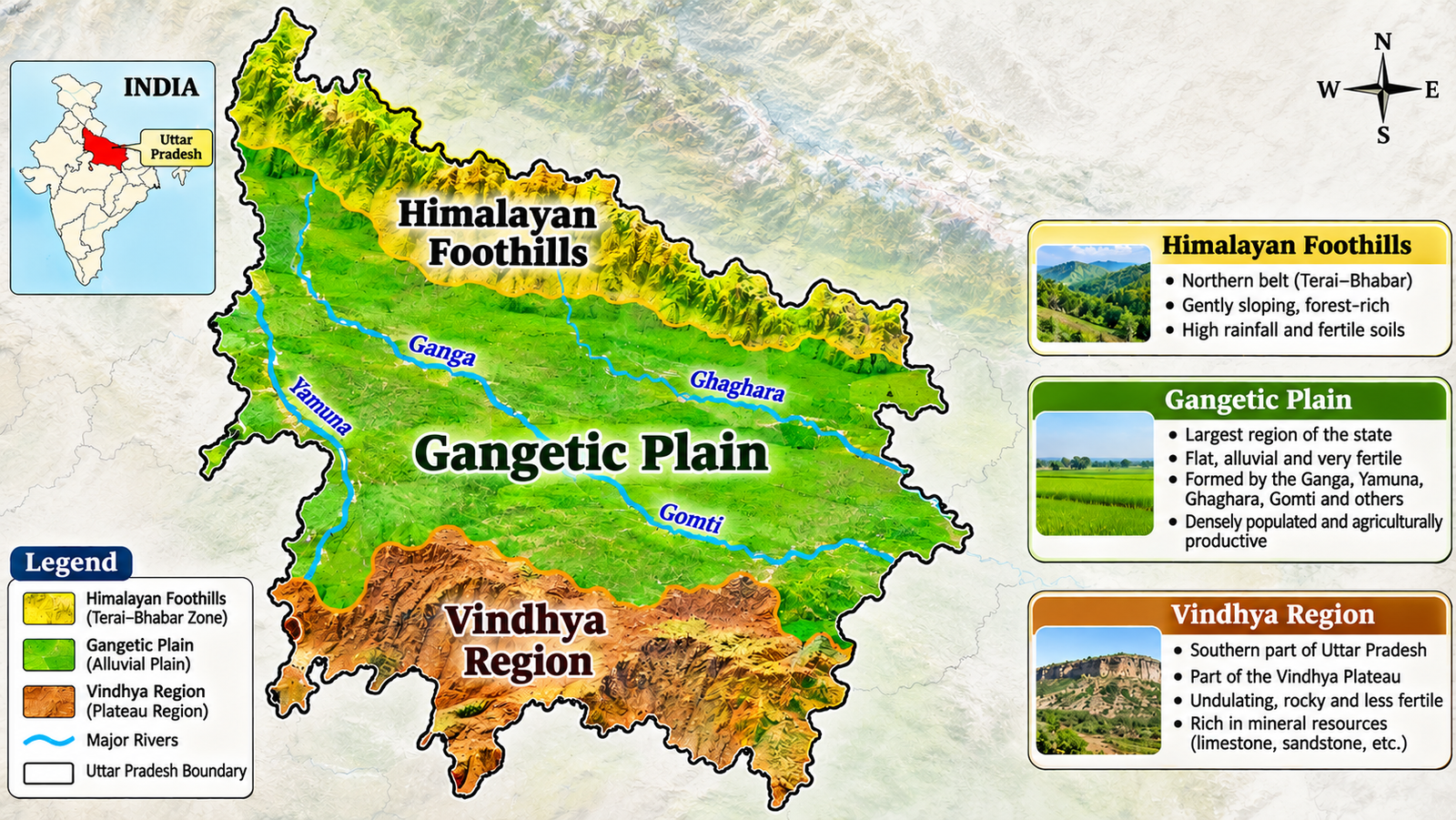
Major Geographical Regions of Uttar Pradesh
Uttar Pradesh can broadly be divided into the following geographical regions.
Terai Region
The Terai region lies along the Nepal border in the northern part of the state.
Important characteristics:
- High moisture and humidity
- Fertile soil
- Dense vegetation in several areas
- A relatively high water table
- Important agricultural and wildlife areas
The Terai region is suitable for crops such as rice and sugarcane. It also contains important protected areas, including Dudhwa National Park.
Gangetic Plain
The Gangetic Plain is the largest and most agriculturally productive geographical region of Uttar Pradesh.
Important characteristics:
- Extensive alluvial deposits
- Fertile soil
- Flat or gently sloping terrain
- Dense river network
- Intensive agriculture
- High population density
The Ganga and its tributaries support agriculture, settlements, transportation and economic activities throughout the region.
Bundelkhand Region
Bundelkhand lies mainly in the southern part of Uttar Pradesh and extends into Madhya Pradesh.
Important characteristics:
- Rocky and uneven terrain
- Seasonal rivers and streams
- Water scarcity in several areas
- Drought-prone conditions
- Dependence on rainfall in many agricultural areas
Important districts associated with the Uttar Pradesh part of Bundelkhand include Jhansi, Jalaun, Lalitpur, Hamirpur, Mahoba, Banda and Chitrakoot.
Vindhyan Region
The Vindhyan region is located in the southeastern part of Uttar Pradesh. It includes parts of Mirzapur and Sonbhadra and is characterised by:
- Rocky and hilly terrain
- Plateaus and escarpments
- Forested areas
- Mineral resources
- Rivers and seasonal streams
The region differs geographically from the fertile Gangetic Plain.
Understanding these physical regions is essential for solving region-based questions in Uttar Pradesh Geography for UPPCS.
After completing Uttar Pradesh Geography, revise the complete UPPCS Prelims syllabus with our UPPCS Prelims 2026: Ultimate Revision Guide, MCQs & Free PDF to strengthen your overall exam preparation.

Rivers of Uttar Pradesh
Rivers are among the most important topics in Uttar Pradesh Geography for UPPCS. They influence agriculture, settlements, transportation, irrigation and the development of cities.
The major rivers of Uttar Pradesh belong mainly to the Ganga river system.
Ganga River
The Ganga is the most important river of Uttar Pradesh.
Key facts:
- It flows through the central and eastern parts of the state.
- It supports agriculture and settlements across the Gangetic Plain.
- It receives several major tributaries.
- It is associated with important cities such as Kanpur, Prayagraj and Varanasi.
Yamuna River
The Yamuna is a major tributary of the Ganga.
Important facts:
- It flows through the western and southern parts of Uttar Pradesh.
- It passes near important cities such as Mathura and Agra.
- It joins the Ganga at Prayagraj.
- The confluence of the Ganga and Yamuna is traditionally associated with the Triveni Sangam.
Gomti River
The Gomti is an important river flowing through Uttar Pradesh.
Important facts:
- It is associated with Lucknow.
- It flows through the central part of the state.
- It joins the Ganga near Ghazipur.
For a deeper understanding of Uttar Pradesh’s river system, revise the Ganga, Yamuna, Gomti, Ghaghara, and other important rivers through our Important Rivers of Uttar Pradesh: Powerful UPPCS Notes, Map & 100 MCQs. This focused resource includes map-based revision and practice questions for UPPCS Prelims.
Ghaghara River
The Ghaghara is an important Himalayan river system flowing through northern and eastern Uttar Pradesh.
Important facts:
- It is known for its large water volume during the monsoon.
- It supports agriculture in the northern and eastern plains.
- Flooding can affect areas along its course.
Rapti River
The Rapti flows through the eastern Terai region.
Important facts:
- It is associated with the Gorakhpur region.
- It is important for the drainage of the eastern Terai.
- Flooding may occur during the monsoon.
Betwa River
The Betwa is an important river of the Bundelkhand region.
Important facts:
- It is a tributary of the Yamuna.
- It flows through parts of Madhya Pradesh and Uttar Pradesh.
- It is important for irrigation and water management in Bundelkhand.
To strengthen your understanding of India’s drainage system, explore our detailed guide on Himalayan Rivers vs Peninsular Rivers UPSC: 15 Powerful Differences & Key Facts, covering their origins, characteristics, drainage patterns and major differences for UPSC preparation.
Ken River
The Ken is another important river associated with Bundelkhand.
Important facts:
- It flows through Madhya Pradesh and Uttar Pradesh.
- It is a tributary of the Yamuna.
- It is associated with the Panna region and the Ken River landscape.
Important River Confluence
The confluence of the Ganga, Yamuna and the traditionally recognised Saraswati is known as Triveni Sangam, located at Prayagraj.
For effective UPSC Prelims preparation, strengthen your knowledge of India’s river systems by practising 100 Powerful Himalayan Peninsular Rivers MCQs for UPSC: Master Your Prelims!, featuring important questions with answers and brief explanations.
Major Rivers: Quick Revision Table
| River | Important Association |
|---|---|
| Ganga | Major river of the Gangetic Plain |
| Yamuna | Joins Ganga at Prayagraj |
| Gomti | Lucknow; joins Ganga near Ghazipur |
| Ghaghara | Northern and eastern plains; flood-prone areas |
| Rapti | Gorakhpur and eastern Terai |
| Betwa | Bundelkhand; tributary of Yamuna |
| Ken | Bundelkhand; tributary of Yamuna |
| Chambal | Part of the Yamuna river system; ravine landscape |
River origins, tributaries, confluences and the cities located along their banks are frequently useful areas for Uttar Pradesh Geography for UPPCS revision.
The major rivers and their tributaries are frequently studied under Uttar Pradesh Geography for UPPCS because they influence the state’s agriculture, settlement patterns, irrigation, and regional development.
Along with practising subject-wise questions, aspirants should understand the examination structure, syllabus, and marking scheme. Read our detailed guide on UPPCS 2026 Prelims Exam Pattern : Latest Syllabus & Marking Scheme Easy Guide.
Climate of Uttar Pradesh
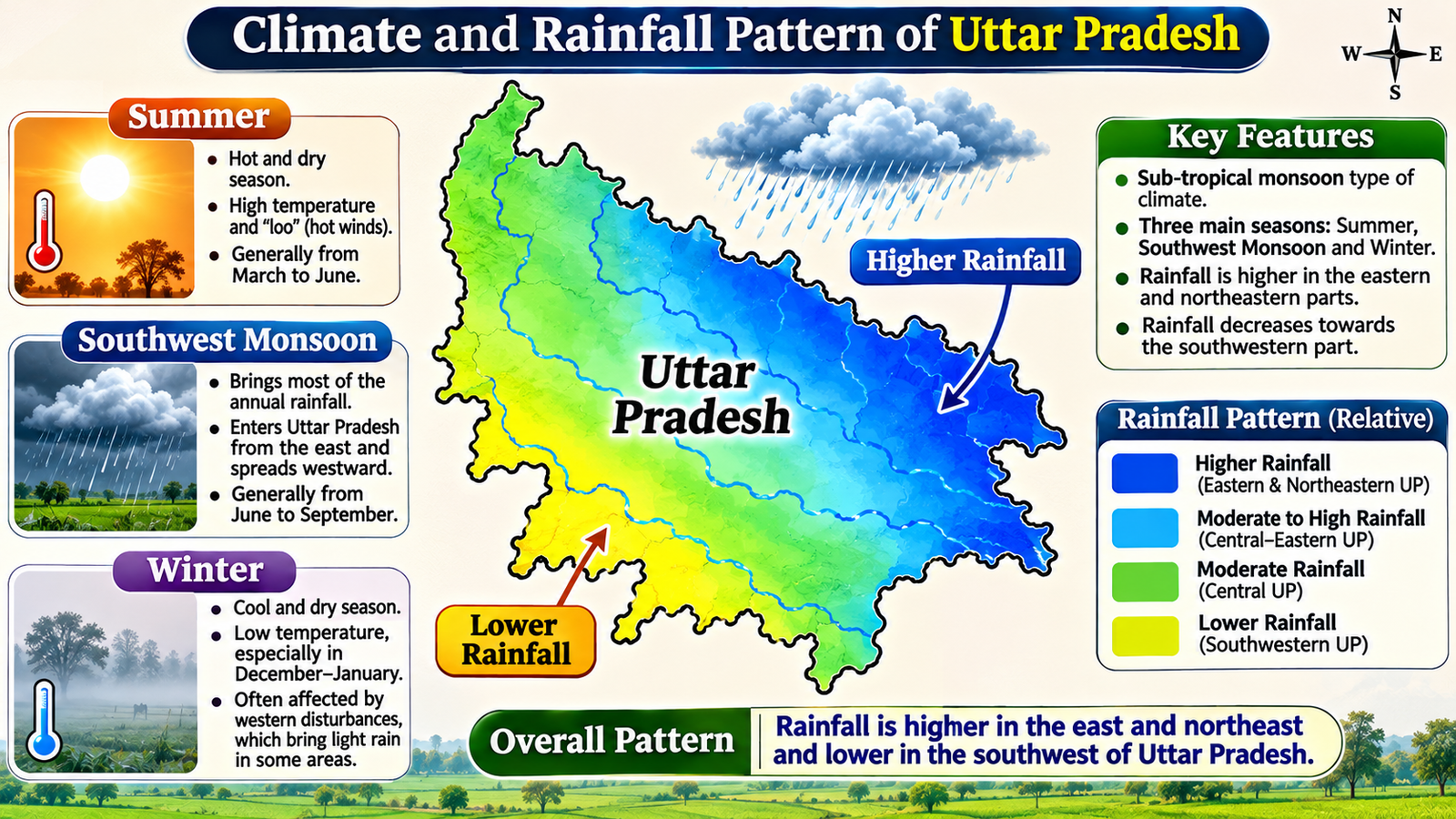
Uttar Pradesh experiences a subtropical climate. The climate varies across the state due to differences in location, elevation, rainfall and distance from the Himalayan region.
Major Seasons
| Season | Approximate Period |
|---|---|
| Summer | March to June |
| Monsoon | June to September |
| Post-monsoon | October |
| Winter | November to February |
Summer
- Temperatures rise significantly.
- Hot and dry winds may occur in western and central areas.
- Water demand increases.
- Heat waves can affect several parts of the state.
Monsoon
- Most of the annual rainfall occurs during the southwest monsoon.
- Rainfall is important for agriculture.
- Flooding may affect riverine and low-lying areas.
- Rainfall varies across western, central and eastern Uttar Pradesh.
Winter
- Temperatures fall during the winter months.
- Fog is common in several parts of the Gangetic Plain.
- Cold waves may affect northern India.
- Winter rainfall may occur due to western disturbances.
Exam Point: The monsoon is particularly important for agriculture in areas where irrigation facilities are limited.
Climate-related topics are another important area of Uttar Pradesh Geography for UPPCS, particularly the southwest monsoon, rainfall distribution, seasonal variations, and their impact on agricultural activities.
Soil Types of Uttar Pradesh
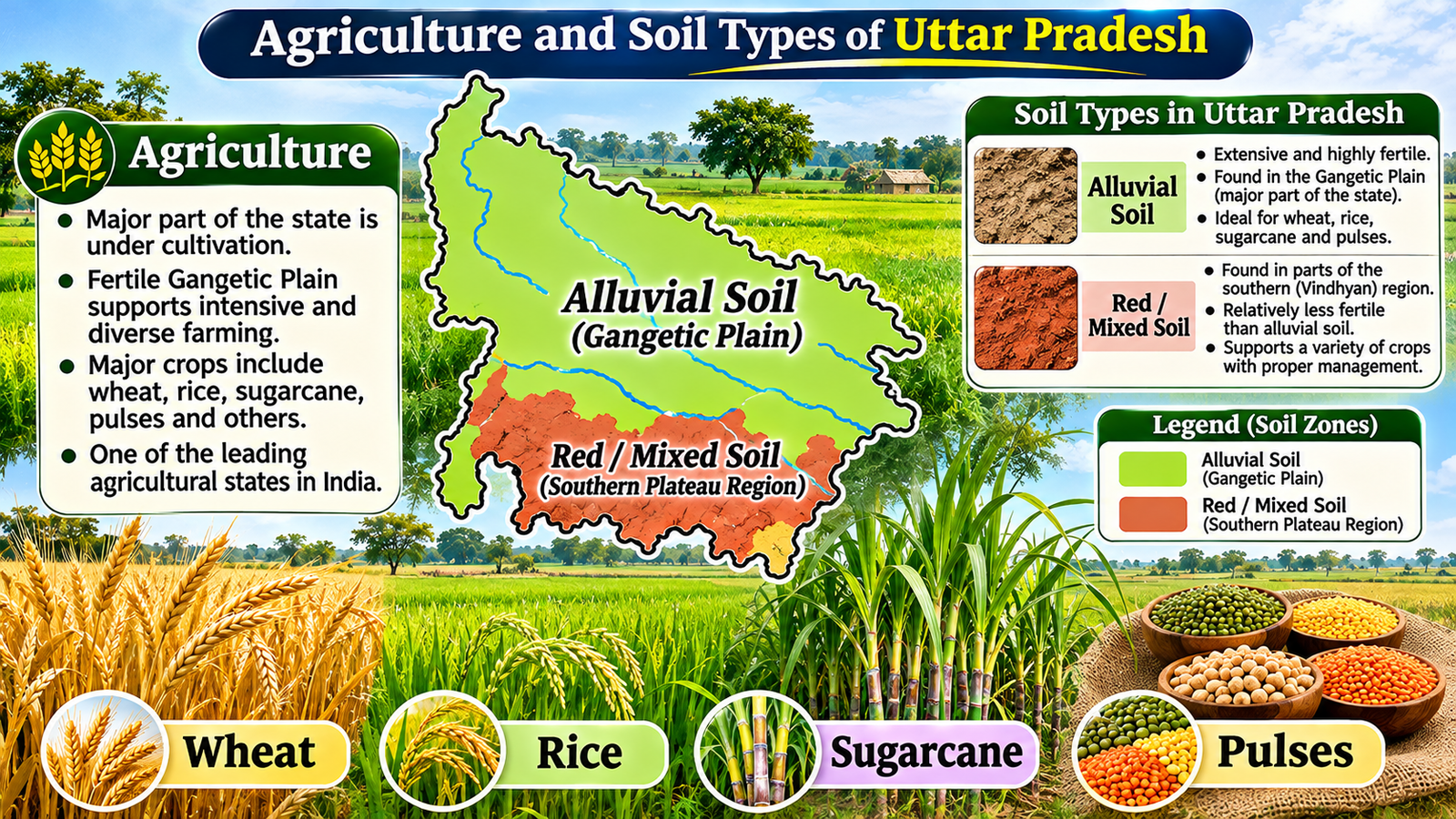
Soil is an important topic because it is closely connected with agriculture, crop distribution and regional geography.
Alluvial Soil
Alluvial soil is the dominant soil type in the Gangetic Plain.
Characteristics:
- Fertile
- Suitable for intensive agriculture
- Formed through river deposits
- Supports crops such as wheat, rice, sugarcane and pulses
Terai Soil
Terai soil is found in the northern belt near the Nepal border.
Characteristics:
- High moisture content
- Generally fertile
- Supports agriculture and vegetation
- Found in areas influenced by Himalayan drainage
Red and Yellow Soil
Red and yellow soils occur in parts of the southern and southeastern regions.
Characteristics:
- Associated with older geological formations
- Found in parts of the plateau region
- May require soil management and irrigation for improved agricultural productivity
Bundelkhand Soil
The Bundelkhand region has varied soils, including shallow and rocky soils in several areas.
Characteristics:
- Soil depth varies considerably
- Some areas have limited moisture retention
- Agriculture is influenced by rainfall and irrigation availability
For better preparation of Uttar Pradesh Geography for UPPCS, aspirants should understand the relationship between soil types, irrigation facilities, cropping patterns, and the agricultural economy of the state.
Agriculture and Major Crops
Agriculture is a major economic activity in Uttar Pradesh. The fertile Gangetic Plain, river systems, irrigation facilities and favourable soil conditions support a wide range of crops.
Major Crops
| Crop | Important Information |
|---|---|
| Wheat | Major rabi crop |
| Rice | Major kharif crop |
| Sugarcane | Important commercial crop |
| Potato | Important crop in several districts |
| Pulses | Include gram, lentil and arhar |
| Mustard | Important oilseed crop |
| Maize | Grown in different parts of the state |
Rabi Crops
Rabi crops are generally sown during the winter season and harvested in spring.
Examples:
- Wheat
- Gram
- Mustard
- Lentil
Kharif Crops
Kharif crops are generally sown with the onset of the monsoon.
Examples:
- Rice
- Maize
- Arhar
- Some millets
Sugarcane
Sugarcane is an important commercial crop in Uttar Pradesh.
It supports:
- Sugar industries
- Jaggery production
- Rural employment
- Agricultural trade
Sugarcane cultivation is particularly important in western and northern parts of the state.
Candidates should connect crop distribution with soil type, rainfall and irrigation while preparing Uttar Pradesh Geography for UPPCS.
Forests and Wildlife of Uttar Pradesh
Uttar Pradesh has a range of forest and wildlife habitats, including Terai forests, riverine ecosystems, wetlands and dry forest areas.
Protected areas are important for biodiversity conservation and tourism.
Dudhwa National Park
- Located in the Terai region.
- Known for its biodiversity.
- Associated with important wildlife conservation efforts.
- The wider Dudhwa landscape includes important habitats for large mammals and birds.
Pilibhit Tiger Reserve
- Located in the Terai region.
- Important for tiger conservation.
- Contains forest and grassland habitats.
Katarniaghat Wildlife Sanctuary
- Located in the Terai region.
- Associated with the Girwa River and important wildlife habitats.
- Known for its biodiversity.
National Chambal Sanctuary
- Associated with the Chambal River.
- Important for aquatic wildlife conservation.
- Known for species such as the gharial and Gangetic dolphin.
Map Practice: Locate Dudhwa, Pilibhit, Katarniaghat and the National Chambal Sanctuary on a map of Uttar Pradesh.
Natural Resources and Minerals
The southern and southeastern parts of Uttar Pradesh contain important mineral and geological resources.
Sonbhadra is particularly important for mineral resources and energy-related activities.
Important Mineral and Resource Areas
- Sonbhadra: Associated with mineral resources and major energy infrastructure.
- Mirzapur: Known for its geographical diversity and stone-related resources.
- Bundelkhand: Contains varied geological formations and mineral deposits.
The distribution of minerals is influenced by the geological structure of the southern plateau and Vindhyan region.
The study of minerals, forests, water resources, and energy production further strengthens the geographical understanding required for Uttar Pradesh Geography for UPPCS.
Important Geographical Places
The following places are useful for map-based revision:
| Place | Geographical or Environmental Importance |
|---|---|
| Prayagraj | Triveni Sangam |
| Varanasi | Located on the Ganga |
| Lucknow | Located on the Gomti |
| Agra | Located on the Yamuna |
| Mathura | Located on the Yamuna |
| Gorakhpur | Associated with the Rapti River |
| Sonbhadra | Vindhyan region and mineral resources |
| Jhansi | Bundelkhand region |
| Dudhwa | Terai wildlife landscape |
| Pilibhit | Terai region and tiger reserve |

Map-Based Revision Facts
Map-based questions are important for UPPCS Prelims. Aspirants should practise locating geographical features rather than memorising names alone.
Map-Based Revision Checklist
While practising the map of Uttar Pradesh, locate:
- All 75 districts
- 18 administrative divisions
- Ganga, Yamuna, Gomti, Ghaghara, Rapti, Betwa and Ken rivers
- Dudhwa National Park
- Pilibhit Tiger Reserve
- Katarniaghat Wildlife Sanctuary
- National Chambal Sanctuary
- Major cities such as Lucknow, Prayagraj, Varanasi, Kanpur, Agra and Gorakhpur
- The Nepal border and neighbouring Indian states
How to Practise Map Questions
- Begin with the outline map of Uttar Pradesh.
- Mark the northern Terai belt.
- Trace the Ganga and Yamuna rivers.
- Locate major tributaries.
- Mark the Bundelkhand and Vindhyan regions.
- Identify national parks and wildlife sanctuaries.
- Revise the map regularly.
Regular map practice can strengthen your preparation for location-based questions in Uttar Pradesh Geography for UPPCS.
Understanding the physical features of Uttar Pradesh is an essential part of Uttar Pradesh Geography for UPPCS, as questions related to the Himalayan foothills, Gangetic plains, and southern plateau regions are important for state-level examinations.
These quick revision points will help aspirants revise the most important facts of Uttar Pradesh Geography for UPPCS before attempting the practice questions.
Important One-Liners for UPPCS
- Uttar Pradesh is located in northern India.
- The Ganga is the most important river of the state.
- The Yamuna joins the Ganga at Prayagraj.
- The Gomti flows through Lucknow.
- The Gomti joins the Ganga near Ghazipur.
- The Terai region lies along the Nepal border.
- The Gangetic Plain is the major agricultural region of Uttar Pradesh.
- Bundelkhand is associated with rocky terrain and water scarcity.
- The Vindhyan region is located in southeastern Uttar Pradesh.
- Dudhwa National Park is located in the Terai region.
- Sugarcane is an important commercial crop.
- Wheat is a major rabi crop.
- Rice is a major kharif crop.
- Triveni Sangam is located at Prayagraj.
- Sonbhadra is important for mineral resources and energy infrastructure.
The following practice questions are designed to test your understanding of Uttar Pradesh Geography for UPPCS and help you identify important areas for further revision.
Practising previous-year questions is essential for understanding the actual UPPCS exam pattern and question trends. Continue your preparation with UPPCS Prelims PYQs: Most Important Guide 2026-27.
Uttar Pradesh Geography MCQs for UPPCS
These practice questions cover important concepts and factual areas of Uttar Pradesh Geography for UPPCS, including rivers, climate, agriculture and physical regions.
Question 1. The Triveni Sangam is located at:
A. Varanasi
B. Prayagraj
C. Kanpur
D. Agra
Question 2. Which river flows through Lucknow?
A. Yamuna
B. Betwa
C. Gomti
D. Ken
Question 3. Which geographical region is located along the Nepal border?
A. Bundelkhand
B. Terai
C. Vindhyan
D. Gangetic Plain
Question 4. Which of the following is a major rabi crop of Uttar Pradesh?
A. Wheat
B. Rice
C. Arhar
D. Jute
Question 5. Dudhwa National Park is located in which region?
A. Bundelkhand
B. Vindhyan
C. Terai
D. Southern Gangetic Plain
Question 6. Which river is a tributary of the Yamuna?
A. Gomti
B. Betwa
C. Ghaghara
D. Rapti
Question 7. Which region is associated with rocky terrain and water scarcity?
A. Terai
B. Gangetic Plain
C. Bundelkhand
D. Northern Plain
Question 8. Which soil type is dominant in the Gangetic Plain of Uttar Pradesh?
A. Alluvial soil
B. Laterite soil
C. Black soil
D. Desert soil
Question 9. The Gomti River joins the Ganga near:
A. Prayagraj
B. Ghazipur
C. Agra
D. Mathura
Question 10. Which of the following is associated with the Vindhyan region of Uttar Pradesh?
A. Sonbhadra
B. Bijnor
C. Saharanpur
D. Pilibhit
Question 11. Uttar Pradesh is located in which part of India?
A. Southern India
B. Northern India
C. Western India
D. Northeastern India
Question 12. Which country shares an international boundary with Uttar Pradesh?
A. Bangladesh
B. Bhutan
C. Nepal
D. Pakistan
Question 13. Which river is associated with the city of Agra?
A. Gomti
B. Yamuna
C. Rapti
D. Ghaghara
Question 14. Which river is associated with Gorakhpur?
A. Rapti
B. Ken
C. Betwa
D. Chambal
Question 15. Which of the following rivers is associated with Bundelkhand?
A. Betwa
B. Gomti
C. Ghaghara
D. Gandak
Question 16. The Gangetic Plain is primarily characterised by:
A. Desert sand dunes
B. Fertile alluvial deposits
C. High volcanic mountains
D. Dense alpine forests
Question 17. Which of the following is a major kharif crop?
A. Wheat
B. Mustard
C. Rice
D. Gram
Question 18. Which crop is an important commercial crop in Uttar Pradesh?
A. Sugarcane
B. Apple
C. Coffee
D. Rubber
Question 19. The Terai region is generally characterised by:
A. Low moisture and desert vegetation
B. High moisture and fertile soil
C. Permanent snow cover
D. Extensive sand dunes
Question 20. Which river joins the Ganga at Prayagraj?
A. Yamuna
B. Gomti
C. Rapti
D. Ken
Question 21. Which of the following is a tributary of the Yamuna?
A. Ken
B. Gomti
C. Ghaghara
D. Rapti
Question 22. The climate of Uttar Pradesh is generally described as:
A. Equatorial
B. Subtropical
C. Mediterranean
D. Tundra
Question 23. Most of the annual rainfall in Uttar Pradesh occurs during:
A. Winter
B. Southwest monsoon
C. Spring
D. Early summer
Question 24. Which phenomenon is commonly associated with winter in the Gangetic Plain?
A. Fog
B. Tropical cyclones every day
C. Permanent snowfall
D. Sandstorms throughout the season
Question 25. Which soil is generally most suitable for intensive agriculture in the Gangetic Plain?
A. Alluvial soil
B. Desert soil
C. Laterite soil
D. Mountain podzol
Question 26. Which region of Uttar Pradesh extends into Madhya Pradesh?
A. Terai
B. Bundelkhand
C. Upper Gangetic Plain
D. Bhabar
Question 27. Which of the following districts is associated with the Bundelkhand region?
A. Jhansi
B. Saharanpur
C. Bijnor
D. Bahraich
Question 28. Which of the following is located in the Terai region?
A. Dudhwa National Park
B. National Chambal Sanctuary
C. Vindhyan Plateau
D. Bundelkhand Plateau
Question 29. Pilibhit Tiger Reserve is located in which broad geographical region?
A. Terai
B. Bundelkhand
C. Vindhyan
D. Desert region
Question 30. National Chambal Sanctuary is associated with which river?
A. Ganga
B. Chambal
C. Gomti
D. Rapti
Question 31. Which animal is particularly associated with the conservation landscape of the National Chambal Sanctuary?
A. Gharial
B. Snow leopard
C. Red panda
D. Wild yak
Question 32. Sonbhadra is important for:
A. Mineral resources and energy infrastructure
B. Coral reefs
C. Alpine glaciers
D. Coastal fisheries
Question 33. Which of the following is a major river of the Ganga system in Uttar Pradesh?
A. Gomti
B. Periyar
C. Narmada
D. Kaveri
Question 34. Which river flows through the central part of Uttar Pradesh and is associated with Lucknow?
A. Gomti
B. Ken
C. Betwa
D. Chambal
Question 35. Which of the following is a major geographical region in southeastern Uttar Pradesh?
A. Vindhyan region
B. Thar Desert
C. Malabar Coast
D. Deccan coastal plain
Question 36. Which of the following rivers is associated with the eastern Terai and Gorakhpur area?
A. Rapti
B. Betwa
C. Ken
D. Chambal
Question 37. Which city is associated with the Ganga River?
A. Varanasi
B. Shimla
C. Jaipur
D. Bhopal
Question 38. Which city is associated with the Yamuna River?
A. Agra
B. Lucknow
C. Gorakhpur
D. Bahraich
Question 39. Which of the following is a rabi crop?
A. Wheat
B. Rice
C. Arhar
D. Jute
Question 40. Which of the following is an oilseed crop grown in Uttar Pradesh?
A. Mustard
B. Tea
C. Coffee
D. Rubber
Question 41. Which river is a tributary of the Ganga and flows through the eastern part of Uttar Pradesh?
A. Gomti
B. Narmada
C. Tapi
D. Sabarmati
Question 42. Which of the following is a major feature of the Bundelkhand region?
A. Rocky terrain
B. Permanent glaciers
C. Coastal lagoons
D. Coral islands
Question 43. Which of the following is a major geographical feature of the Gangetic Plain?
A. Extensive alluvial deposits
B. Active volcanic cones
C. High alpine peaks
D. Deep ocean trenches
Question 44. Which of the following is associated with the Terai belt of Uttar Pradesh?
A. High moisture
B. Extremely low rainfall throughout the year
C. Permanent snow cover
D. Coastal climate
Question 45. Which river is associated with the Ken River landscape?
A. Ken
B. Gomti
C. Ghaghara
D. Rapti
Question 46. Which of the following is a major city located on the Gomti River?
A. Lucknow
B. Agra
C. Mathura
D. Jhansi
Question 47. Which of the following is an important wildlife area in the Terai region?
A. Katarniaghat Wildlife Sanctuary
B. Great Himalayan National Park
C. Gir National Park
D. Periyar Tiger Reserve
Question 48. Which of the following is associated with the Yamuna river system?
A. Chambal
B. Mahanadi
C. Godavari
D. Brahmaputra
Question 49. Which of the following best describes the agricultural significance of the Gangetic Plain?
A. Fertile soil and intensive agriculture
B. Permanent snow cover
C. Very limited river water
D. Mainly nomadic pastoralism
Question 50. Which of the following is the best method to prepare for map-based Uttar Pradesh Geography questions?
A. Memorise only city names
B. Practise locating rivers, districts, regions and protected areas on a map
C. Avoid maps and study only definitions
D. Study only national capitals
Along with geography, art and culture are important areas of Uttar Pradesh-related general studies. Practise more questions with our Top 100 Art & Culture MCQs UPPCS Prelims 2026 | Complete Practice Set.
Answer Key with Brief Explanations
| Q. No. | Answer | Brief Explanation |
|---|---|---|
| 1 | B. Prayagraj | Triveni Sangam is located at Prayagraj. |
| 2 | C. Gomti | The Gomti flows through Lucknow. |
| 3 | B. Terai | The Terai region lies along the Nepal border. |
| 4 | A. Wheat | Wheat is a major rabi crop. |
| 5 | C. Terai | Dudhwa National Park is located in the Terai region. |
| 6 | B. Betwa | The Betwa is a tributary of the Yamuna. |
| 7 | C. Bundelkhand | Bundelkhand is associated with rocky terrain and water scarcity. |
| 8 | A. Alluvial soil | Alluvial soil is widespread in the Gangetic Plain. |
| 9 | B. Ghazipur | The Gomti joins the Ganga near Ghazipur. |
| 10 | A. Sonbhadra | Sonbhadra is associated with the southeastern Vindhyan region. |
| 11 | B. Northern India | Uttar Pradesh is located in northern India. |
| 12 | C. Nepal | Uttar Pradesh shares an international boundary with Nepal. |
| 13 | B. Yamuna | The Yamuna flows through Agra. |
| 14 | A. Rapti | The Rapti is associated with the Gorakhpur region. |
| 15 | A. Betwa | The Betwa is an important river of Bundelkhand. |
| 16 | B. Fertile alluvial deposits | River deposits have formed extensive fertile plains. |
| 17 | C. Rice | Rice is a major kharif crop. |
| 18 | A. Sugarcane | Sugarcane is an important commercial crop in the state. |
| 19 | B. High moisture and fertile soil | The Terai is characterised by moisture-rich conditions. |
| 20 | A. Yamuna | The Yamuna joins the Ganga at Prayagraj. |
| 21 | A. Ken | The Ken is a tributary of the Yamuna. |
| 22 | B. Subtropical | Uttar Pradesh generally experiences a subtropical climate. |
| 23 | B. Southwest monsoon | Most annual rainfall occurs during the southwest monsoon. |
| 24 | A. Fog | Fog is common during winter in the Gangetic Plain. |
| 25 | A. Alluvial soil | Alluvial soil is fertile and supports intensive agriculture. |
| 26 | B. Bundelkhand | Bundelkhand extends across Uttar Pradesh and Madhya Pradesh. |
| 27 | A. Jhansi | Jhansi is associated with the Bundelkhand region. |
| 28 | A. Dudhwa National Park | Dudhwa is located in the Terai region. |
| 29 | A. Terai | Pilibhit Tiger Reserve lies in the Terai belt. |
| 30 | B. Chambal | The sanctuary is associated with the Chambal River. |
| 31 | A. Gharial | The National Chambal Sanctuary is important for gharial conservation. |
| 32 | A. Mineral resources and energy infrastructure | Sonbhadra is known for its mineral and energy-related resources. |
| 33 | A. Gomti | The Gomti is part of the Ganga river system. |
| 34 | A. Gomti | The Gomti flows through Lucknow. |
| 35 | A. Vindhyan region | The Vindhyan region lies in southeastern Uttar Pradesh. |
| 36 | A. Rapti | The Rapti is associated with the eastern Terai and Gorakhpur. |
| 37 | A. Varanasi | Varanasi is located on the Ganga. |
| 38 | A. Agra | Agra is located on the Yamuna. |
| 39 | A. Wheat | Wheat is a major rabi crop. |
| 40 | A. Mustard | Mustard is an important oilseed crop. |
| 41 | A. Gomti | The Gomti is a tributary of the Ganga. |
| 42 | A. Rocky terrain | Rocky terrain is a characteristic feature of Bundelkhand. |
| 43 | A. Extensive alluvial deposits | The Gangetic Plain has extensive river-deposited alluvium. |
| 44 | A. High moisture | The Terai is generally moisture-rich. |
| 45 | A. Ken | The Ken River is associated with the Bundelkhand landscape. |
| 46 | A. Lucknow | Lucknow is located on the Gomti River. |
| 47 | A. Katarniaghat Wildlife Sanctuary | Katarniaghat is an important wildlife area in the Terai. |
| 48 | A. Chambal | The Chambal is a tributary of the Yamuna. |
| 49 | A. Fertile soil and intensive agriculture | The Gangetic Plain supports intensive agriculture due to its fertile soil. |
| 50 | B. Practise locating rivers, districts, regions and protected areas on a map | Map practice helps develop spatial understanding and improves map-based question accuracy. |
For additional current affairs practice, especially for the latest sports-related developments, attempt our Valuable October 2026 Sports Current Affairs MCQs for UPSC, PCS & SSC with Answers.
Conclusion
Uttar Pradesh Geography is an important component of state-specific General Studies for UPPCS Prelims. A strong understanding of rivers, physical regions, climate, soil, agriculture, wildlife and geographical locations can help aspirants answer both direct and map-based questions.
Use these Uttar Pradesh Geography for UPPCS notes for revision, practise locating important features on a map and regularly solve MCQs to strengthen your preparation.
Aspirants should also stay updated with the latest examination announcements and important dates. Check our article on UPPCS Prelims Exam Date 2026 Officially Announced: Great News for Aspirants for the latest exam-related information.
Frequently Asked Questions
Question 1. Which topics are important in Uttar Pradesh Geography for UPPCS?
Important topics include geographical location, physical regions, rivers, climate, soil, agriculture, forests, wildlife, minerals and map-based facts.
Question 2. Which is the most important river of Uttar Pradesh?
The Ganga is the most important river of Uttar Pradesh. It supports agriculture, settlements and economic activities across the Gangetic Plain.
Question 3. Where is Triveni Sangam located?
Triveni Sangam is located at Prayagraj, where the Ganga, Yamuna and the traditionally recognised Saraswati are believed to meet.
Question 4. Which geographical region is known for water scarcity?
Bundelkhand is associated with rocky terrain, water scarcity and drought-prone conditions in several areas.
Question 5. Which national park is located in the Terai region of Uttar Pradesh?
Dudhwa National Park is located in the Terai region of Uttar Pradesh.
Question 6. Which soil is most common in Uttar Pradesh?
Alluvial soil is the dominant soil type across much of the Gangetic Plain.
Question 7. How should I prepare Geography for UPPCS Prelims?
Study the physical regions, rivers, climate, soil, agriculture and wildlife. Practise map-based questions regularly and revise important facts through MCQs.
Recommended Official Resources:
Get Daily Current Affairs MCQs, GK Quizzes and study resources for UPSC, State PCS and SSC examinations.
✈️ Join our Telegram channel "Knowledge Chronicles Plus" for free
1 thought on “Uttar Pradesh Geography for UPPCS: Complete Notes, Important Facts & 50 MCQs”