
Are you preparing for UPSC Prelims, State PCS or other competitive examinations? Practising objective questions is one of the most effective ways to strengthen your understanding of Indian Geography.
These Himalayan Peninsular Rivers MCQs are specially designed to help UPSC aspirants revise important Indian Geography concepts through exam-oriented practice questions.
This practice set contains 100 important Himalayan and Peninsular Rivers MCQs covering the major river systems of India, river origins, tributaries, drainage patterns, deltas, estuaries and important geographical facts.
These questions are divided into five sections, with 20 questions in each section. Answers and brief explanations are provided at the end of every section so that you can evaluate your performance and revise important concepts.
Whether you are studying the Himalayan River System of India or the Peninsular River System of India, these Himalayan Peninsular Rivers MCQs will help you prepare for UPSC Prelims and other geography-based examinations.
Practising Himalayan Peninsular Rivers MCQs regularly can improve your understanding of river systems, tributaries, drainage patterns and other important geographical facts.
Before attempting these practice questions, revise the important concepts, river systems and drainage patterns through our detailed guide on Indian Rivers and Drainage System UPSC Prelims 2027: Important Facts for Success.
Attempt all 100 questions without checking the answers first!

Section 1: Basic Concepts and Himalayan Rivers (Questions 1–20)
This section focuses on the three major Himalayan river systems—Indus, Ganga and Brahmaputra. It covers their origins, tributaries, important confluences and geographical characteristics. These are fundamental areas of the Indian drainage system and are frequently relevant to UPSC Geography questions.
These Himalayan Peninsular Rivers MCQs cover important facts about the Indus, Ganga and Brahmaputra river systems.
Q1. Which of the following are the three major Himalayan river systems of India?
A. Godavari, Krishna and Kaveri
B. Indus, Ganga and Brahmaputra
C. Narmada, Tapi and Mahanadi
D. Mahanadi, Godavari and Indus
Q2. The Ganga is formed by the confluence of which two rivers?
A. Yamuna and Ganga
B. Bhagirathi and Alaknanda
C. Mandakini and Yamuna
D. Ghaghara and Gandak
Q3. The confluence of Bhagirathi and Alaknanda takes place at:
A. Rudraprayag
B. Karnaprayag
C. Devprayag
D. Vishnuprayag
Q4. The Brahmaputra is known as which river in Tibet?
A. Dihang
B. Yarlung Tsangpo
C. Jamuna
D. Meghna
Q5. Which of the following is a major tributary of the Indus?
A. Kaveri
B. Beas
C. Godavari
D. Mahanadi
Q6. Himalayan rivers are generally perennial because they receive water from:
A. Only groundwater
B. Only monsoon rainfall
C. Rainfall and snow or glacier melt
D. Only artificial reservoirs
Q7. Which of the following is associated with the Ganga River System?
A. Son
B. Bhima
C. Periyar
D. Sharavati
Q8. Which river enters India through Arunachal Pradesh as the Siang or Dihang?
A. Indus
B. Brahmaputra
C. Sutlej
D. Ganga
Q9. Which of the following is a characteristic of Himalayan rivers in their upper courses?
A. Deep gorges
B. Extensive coastal estuaries
C. Absence of erosion
D. No tributaries
Q10. Which of the following rivers belongs to the Indus River System?
A. Ravi
B. Kosi
C. Gomti
D. Son
Q11. The source region of the Indus River is located near:
A. Lake Mansarovar
B. Wular Lake
C. Chilika Lake
D. Dal Lake
Q12. Which of the following rivers is a tributary of the Ganga?
A. Ghaghara
B. Bhima
C. Periyar
D. Sabari
Q13. The Yamuna originates from:
A. Yamunotri Glacier region
B. Gangotri Glacier
C. Amarkantak Plateau
D. Mahabaleshwar
Q14. Which river is known as the Jamuna in Bangladesh?
A. Ganga
B. Brahmaputra
C. Indus
D. Kaveri
Q15. Which of the following is one of the five major rivers of Punjab associated with the Indus system?
A. Beas
B. Gomti
C. Son
D. Chambal
Q16. Which of the following rivers is an important tributary of the Brahmaputra?
A. Subansiri
B. Bhima
C. Kabini
D. Koyna
Q17. The Ganga enters the plains at:
A. Haridwar
B. Devprayag
C. Rishikesh
D. Prayagraj
Q18. Which of the following is an important tributary of the Yamuna?
A. Chambal
B. Indravati
C. Manjira
D. Periyar
Q19. Which river is associated with the Kosi River System?
A. Ganga
B. Godavari
C. Krishna
D. Narmada
Q20. Which of the following is a major feature of Himalayan rivers?
A. Large drainage basins
B. Complete dependence on groundwater
C. Absence of tributaries
D. No sediment transport
For additional knowledge about developments related to the Brahmaputra River system, explore our article on the Siang Dam Project UPSC: Essential Facts & Prelims Guide 2027.
Answers and Explanations – Section 1
- B – Indus, Ganga and Brahmaputra are the three major Himalayan river systems.
- B – Bhagirathi and Alaknanda meet at Devprayag to form the Ganga.
- C – Devprayag is the confluence point of Bhagirathi and Alaknanda.
- B – The Brahmaputra is known as Yarlung Tsangpo in Tibet.
- B – Beas is one of the major tributaries associated with the Indus system.
- C – Rainfall and snow or glacier melt support the perennial nature of Himalayan rivers.
- A – The Son is an important tributary of the Ganga.
- B – The Brahmaputra enters Arunachal Pradesh as the Siang or Dihang.
- A – Strong river erosion in mountainous terrain produces deep gorges.
- A – Ravi is one of the five major rivers associated with the Indus system.
- A – The Indus originates near the Lake Mansarovar region in Tibet.
- A – Ghaghara is an important tributary of the Ganga.
- A – The Yamuna originates from the Yamunotri Glacier region.
- B – The Brahmaputra is known as the Jamuna in Bangladesh.
- A – Beas is one of the five major rivers of Punjab.
- A – Subansiri is an important tributary of the Brahmaputra.
- A – The Ganga enters the northern plains near Haridwar.
- A – Chambal is an important tributary of the Yamuna.
- A – The Kosi is an important tributary of the Ganga.
- A – The major Himalayan river systems have extensive drainage basins.
To strengthen your understanding of the Himalayan region, its geographical divisions, mountain passes and major river systems, read our guide on Himalayan Rivers UPSC Prelims 2027: 100 Outstanding MCQs with Answers & Explanations.

Section 2: Peninsular Rivers of India (Questions 21–40)
This section covers the major Peninsular rivers of India, including Godavari, Krishna, Kaveri, Mahanadi, Narmada and Tapi. Pay special attention to river origins, important tributaries, dams and the direction of river flow. These facts are useful for understanding the Peninsular River System of India and solving UPSC Prelims MCQs.
Attempt these Himalayan Peninsular Rivers MCQs to test your knowledge of major Peninsular rivers, their origins and tributaries.
Q21. Which is the longest river of Peninsular India?
A. Krishna
B. Kaveri
C. Godavari
D. Narmada
Q22. The Godavari originates near:
A. Mahabaleshwar
B. Trimbakeshwar
C. Amarkantak
D. Talakaveri
Q23. The Godavari is popularly known as:
A. Uttar Ganga
B. Dakshin Ganga
C. Eastern Ganga
D. Himalayan Ganga
Q24. Which of the following is a west-flowing Peninsular river?
A. Krishna
B. Godavari
C. Narmada
D. Kaveri
Q25. The Narmada originates from:
A. Amarkantak Plateau
B. Western Ghats near Nashik
C. Brahmagiri Hills
D. Aravalli Range
Q26. The Tapi River originates near:
A. Multai
B. Devprayag
C. Gangotri
D. Mahabaleshwar
Q27. The Kaveri originates at:
A. Talakaveri
B. Amarkantak
C. Trimbakeshwar
D. Multai
Q28. Which of the following is a tributary of the Krishna?
A. Tungabhadra
B. Kosi
C. Gandak
D. Ramganga
Q29. The Mahanadi mainly drains into which water body?
A. Arabian Sea
B. Bay of Bengal
C. Gulf of Kachchh
D. Indian Ocean directly
Q30. Which of the following rivers flows through a rift valley?
A. Narmada
B. Kaveri
C. Godavari
D. Mahanadi
Q31. Which river originates near Mahabaleshwar?
A. Krishna
B. Godavari
C. Narmada
D. Kaveri
Q32. Which of the following is an important tributary of the Godavari?
A. Indravati
B. Beas
C. Ravi
D. Jhelum
Q33. Which of the following rivers is a tributary of the Kaveri?
A. Kabini
B. Kosi
C. Ghaghara
D. Sutlej
Q34. The Narmada drains into:
A. Bay of Bengal
B. Arabian Sea
C. Chilika Lake
D. Gulf of Mannar
Q35. Which river originates in the Brahmagiri Hills?
A. Kaveri
B. Krishna
C. Godavari
D. Tapi
Q36. Which of the following is an important tributary of the Krishna?
A. Bhima
B. Kosi
C. Gandak
D. Ghaghara
Q37. Which river is associated with the Hirakud Dam?
A. Mahanadi
B. Godavari
C. Kaveri
D. Narmada
Q38. Which of the following rivers flows westward into the Arabian Sea?
A. Tapi
B. Godavari
C. Krishna
D. Mahanadi
Q39. Which of the following rivers is associated with the Sardar Sarovar Project?
A. Narmada
B. Kaveri
C. Mahanadi
D. Godavari
Q40. Which of the following statements is correct about Peninsular rivers?
A. All originate from glaciers.
B. Most depend heavily on monsoon rainfall.
C. All flow northward.
D. All drain into the Arabian Sea.
Answers and Explanations – Section 2
- C – The Godavari is the longest river of Peninsular India.
- B – It originates near Trimbakeshwar in Maharashtra.
- B – The Godavari is popularly known as Dakshin Ganga.
- C – The Narmada flows westward towards the Arabian Sea.
- A – The Narmada originates from the Amarkantak Plateau.
- A – The Tapi originates near Multai in Madhya Pradesh.
- A – Talakaveri in the Brahmagiri Hills is the source region of the Kaveri.
- A – Tungabhadra is an important tributary of the Krishna.
- B – The Mahanadi drains into the Bay of Bengal.
- A – The Narmada flows through a rift valley.
- A – The Krishna originates near Mahabaleshwar in Maharashtra.
- A – Indravati is an important tributary of the Godavari.
- A – Kabini is an important tributary of the Kaveri.
- B – The Narmada flows westward and drains into the Arabian Sea.
- A – The Kaveri originates at Talakaveri in the Brahmagiri Hills.
- A – Bhima is an important tributary of the Krishna.
- A – Hirakud Dam is constructed across the Mahanadi.
- A – The Tapi is a major west-flowing Peninsular river.
- A – The Sardar Sarovar Project is associated with the Narmada River.
- B – Most Peninsular rivers depend primarily on monsoon rainfall.
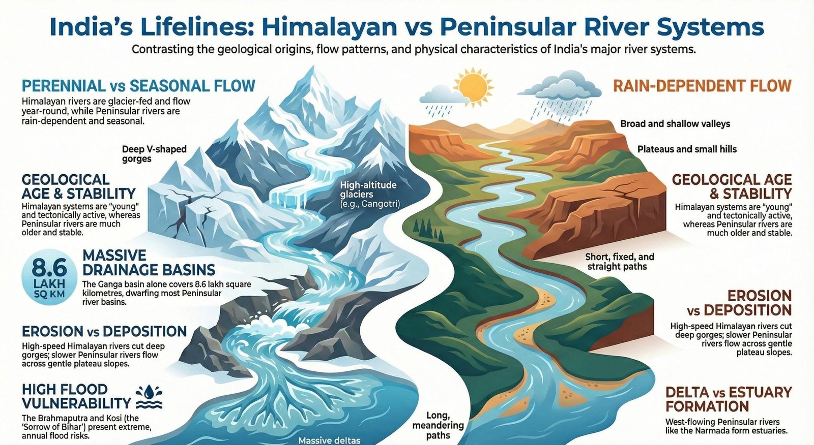
Section 3: Himalayan Rivers vs Peninsular Rivers (Questions 41–60)
This section tests the difference between Himalayan and Peninsular rivers. Questions cover perennial and seasonal rivers, drainage basin size, sediment load, floodplains, river valleys and the geographical reasons behind their flow patterns. Focus on the broad characteristics rather than treating every river as identical.
Want to understand the geographical differences before testing your knowledge? Read our detailed article on Himalayan Rivers vs Peninsular Rivers UPSC: 15 Powerful Differences & Key Facts for a complete conceptual revision.
This section of Himalayan Peninsular Rivers MCQs focuses on the key geographical differences between the two major river systems of India.
Q41. Which river system generally has a greater dependence on snow and glacier melt?
A. Peninsular River System
B. Himalayan River System
C. Coastal River System only
D. Inland Drainage System
Q42. Most Peninsular rivers are primarily dependent on:
A. Glacier melt
B. Monsoon rainfall
C. Snowfall
D. Tidal water
Q43. Which river system generally has larger drainage basins?
A. Himalayan River System
B. Peninsular River System
C. Both always have equal basins
D. Neither has drainage basins
Q44. Which of the following is generally associated with Himalayan rivers?
A. Extensive alluvial floodplains
B. Only rocky riverbeds
C. No sediment transport
D. Complete absence of meanders
Q45. Which of the following is generally true about Peninsular rivers?
A. All originate from glaciers
B. Most depend on monsoon rainfall
C. All flow northward
D. All form estuaries
Q46. Which river system generally carries a larger sediment load from young mountain regions?
A. Himalayan River System
B. Peninsular River System
C. Inland drainage only
D. Small coastal streams only
Q47. Which of the following pairs contains two major west-flowing Peninsular rivers?
A. Godavari and Krishna
B. Narmada and Tapi
C. Kaveri and Mahanadi
D. Ganga and Yamuna
Q48. Most major east-flowing Peninsular rivers drain into:
A. Arabian Sea
B. Bay of Bengal
C. Caspian Sea
D. Red Sea
Q49. Which feature is commonly associated with Himalayan rivers after they enter the northern plains?
A. Meanders and floodplains
B. Only waterfalls
C. Rift valleys throughout
D. No deposition
Q50. Which statement is most accurate?
A. All Himalayan rivers have uniform discharge throughout the year.
B. All Peninsular rivers dry up completely in summer.
C. Himalayan rivers generally have multiple water sources, while most Peninsular rivers are mainly monsoon-dependent.
D. Both river systems originate from glaciers.
Q51. Which river system is generally associated with deep gorges in mountainous regions?
A. Himalayan River System
B. Peninsular River System only
C. Inland drainage system only
D. Coastal streams only
Q52. Which of the following is generally associated with the older geological structure of Peninsular India?
A. Stable plateau region
B. Young fold mountains
C. Recent glacial deposits everywhere
D. Active Himalayan mountain building
Q53. Which river system generally has more extensive alluvial plains in northern India?
A. Himalayan River System
B. Peninsular River System
C. Inland drainage system
D. Small coastal rivers
Q54. Which of the following statements about Peninsular river courses is generally correct?
A. They are always shifting rapidly.
B. They are comparatively stable.
C. They are entirely glacier-fed.
D. They flow only through deserts.
Q55. Which river system generally has a greater influence on the formation of extensive floodplains in northern India?
A. Himalayan River System
B. Peninsular River System
C. Inland drainage system
D. None of these
Q56. Which of the following is a major difference between the two river systems?
A. Himalayan rivers generally receive snowmelt, while most Peninsular rivers depend on rainfall.
B. Both systems are entirely glacier-fed.
C. Peninsular rivers have no tributaries.
D. Himalayan rivers do not carry sediments.
Q57. Which river system generally has a higher potential for seasonal variation due to monsoon dependence?
A. Most Peninsular rivers
B. All Himalayan rivers equally
C. Only the Indus
D. None of these
Q58. Which of the following is generally associated with the upper course of Himalayan rivers?
A. Vertical erosion
B. Extensive coastal delta formation
C. Tidal mixing
D. No erosion
Q59. Which of the following pairs represents one Himalayan and one Peninsular river respectively?
A. Ganga and Godavari
B. Godavari and Krishna
C. Narmada and Tapi
D. Kaveri and Mahanadi
Q60. Which statement best describes the broad difference between Himalayan and Peninsular rivers?
A. Himalayan rivers are generally perennial, while most Peninsular rivers show stronger seasonal variations.
B. All Himalayan rivers are seasonal and all Peninsular rivers are perennial.
C. Both systems have identical origins.
D. Peninsular rivers are always longer than Himalayan rivers.
Answers and Explanations – Section 3
- B – Himalayan rivers receive water from snow and glacier melt in addition to rainfall.
- B – Most Peninsular rivers depend primarily on monsoon rainfall.
- A – The major Himalayan river systems generally have extensive drainage basins.
- A – Himalayan rivers deposit alluvial sediments and develop floodplains in the plains.
- B – Most Peninsular rivers depend heavily on monsoon rainfall.
- A – Erosion in the young Himalayan mountains supplies large quantities of sediments.
- B – Narmada and Tapi are major west-flowing Peninsular rivers.
- B – Most major east-flowing Peninsular rivers drain into the Bay of Bengal.
- A – Meanders and floodplains develop as rivers flow through the plains.
- C – This statement correctly describes the broad differences in water sources.
- A – Himalayan rivers cut deep gorges through mountainous terrain.
- A – Peninsular India is largely an ancient and relatively stable plateau region.
- A – The Himalayan river systems support extensive alluvial plains in northern India.
- B – Peninsular rivers generally follow comparatively stable courses.
- A – Himalayan rivers contribute to the formation of extensive northern floodplains.
- A – The difference in major water sources is a key distinction between the two systems.
- A – Most Peninsular rivers experience greater seasonal variation because of monsoon dependence.
- A – Vertical erosion is prominent in the steep upper courses of Himalayan rivers.
- A – Ganga is a Himalayan river, while Godavari is a Peninsular river.
- A – This is the broadest general distinction between the two river systems.
For a broader understanding of India’s physical features, landforms and geographical processes, explore our Physical Geography for UPSC Prelims 2027: Complete Notes & Important Topics.

Section 4: Drainage Patterns, Deltas and Estuaries (Questions 61–80)
This section covers important geographical concepts related to river drainage patterns and river mouths. Dendritic, trellis, radial and rectangular drainage patterns are important for geography examinations. Questions on delta formation, estuaries, braided channels and the Ganga-Brahmaputra delta also help strengthen your understanding of Indian river geography.
These Indian drainage system MCQs also test your knowledge of river mouths, delta formation, estuaries and drainage patterns.
Q61. Which river system forms the world’s largest delta system along with the Brahmaputra?
A. Indus
B. Ganga
C. Narmada
D. Tapi
Q62. Which of the following Peninsular rivers forms a major delta?
A. Godavari
B. Narmada
C. Tapi
D. Luni
Q63. The Narmada and Tapi are associated with which type of river mouth?
A. Delta
B. Estuary
C. Inland lake
D. Glacier basin
Q64. A dendritic drainage pattern resembles:
A. A tree and its branches
B. A circular ring
C. Parallel straight lines only
D. A rectangular grid only
Q65. Radial drainage develops when rivers flow:
A. Towards a central depression only
B. Outward from a central elevated region
C. Only parallel to the coastline
D. Along a single straight fault
Q66. A trellis drainage pattern commonly develops in areas with:
A. Alternating resistant and less-resistant rock formations
B. Uniform flat desert surfaces only
C. No geological structures
D. Permanent snow cover
Q67. Which of the following is an important feature of the Brahmaputra in Assam?
A. Braided channels
B. Complete absence of sediment
C. Only underground flow
D. No floodplain
Q68. A delta is mainly formed due to:
A. Sediment deposition near a river mouth
B. Glacier movement only
C. Volcanic eruption
D. Wind erosion only
Q69. Which of the following rivers is associated with the Godavari Delta?
A. Godavari
B. Tapi
C. Narmada
D. Beas
Q70. Which of the following statements about estuaries is correct?
A. They are always triangular depositional landforms.
B. They are tidal river mouths where freshwater mixes with seawater.
C. They are found only in Himalayan regions.
D. They are formed exclusively by glaciers.
Q71. Which of the following rivers forms a major delta in Odisha?
A. Mahanadi
B. Narmada
C. Tapi
D. Luni
Q72. Which drainage pattern resembles the branches of a tree?
A. Dendritic
B. Radial
C. Trellis
D. Centripetal
Q73. In a centripetal drainage pattern, rivers flow:
A. Outward from a central hill
B. Towards a central depression
C. Parallel to the coast
D. Only towards the east
Q74. Which of the following rivers is associated with the Sundarbans Delta?
A. Ganga-Brahmaputra system
B. Narmada-Tapi system
C. Krishna-Kaveri system
D. Indus system
Q75. Which of the following is an important factor in delta formation?
A. Sediment deposition
B. Absence of river water
C. Only volcanic activity
D. Only wind action
Q76. Which river is an example of a west-flowing river with an estuarine mouth?
A. Narmada
B. Godavari
C. Krishna
D. Mahanadi
Q77. Which drainage pattern commonly develops in regions with joints and faults producing right-angled bends?
A. Rectangular
B. Dendritic
C. Radial
D. Centripetal
Q78. Which of the following rivers forms a major delta on the eastern coast of India?
A. Krishna
B. Narmada
C. Tapi
D. Luni
Q79. The formation of braided channels is strongly influenced by:
A. High sediment load and channel conditions
B. Absence of sediments
C. Only tidal action
D. Underground water flow
Q80. Which of the following is a correct pair?
A. Narmada – Estuary
B. Godavari – Estuary
C. Krishna – Rift valley
D. Kaveri – Glacier origin
Answers and Explanations – Section 4
- B – The Ganga and Brahmaputra together form the extensive Sundarbans delta system.
- A – The Godavari forms a major delta on the eastern coast.
- B – Narmada and Tapi have estuarine mouths.
- A – Dendritic drainage resembles the branching structure of a tree.
- B – Radial drainage flows outward from an elevated central area.
- A – Trellis drainage is associated with alternating rock structures and differential resistance.
- A – The Brahmaputra has extensive braided channels in Assam.
- A – Deltas develop through sediment accumulation near river mouths.
- A – The Godavari forms a major delta in Andhra Pradesh.
- B – Estuaries are tidal river mouths where freshwater and seawater interact.
- A – The Mahanadi forms a major delta in Odisha.
- A – Dendritic drainage has a tree-like branching appearance.
- B – Centripetal drainage flows towards a central depression or basin.
- A – The Sundarbans is part of the Ganga-Brahmaputra delta system.
- A – Sediment deposition is the main process involved in delta formation.
- A – The Narmada flows westward and has an estuarine mouth.
- A – Rectangular drainage is associated with joints and faults in rocks.
- A – The Krishna forms a major delta on the eastern coast.
- A – High sediment load and channel conditions contribute to braided river formation.
- A – Narmada is a west-flowing river associated with an estuarine mouth.

Section 5: Important UPSC Geography Facts (Questions 81–100)
The final section contains mixed-level questions on important rivers, tributaries, dams, river origins and geographical locations. These questions are designed for quick revision of important Indian river facts. Attempt this section carefully to test your overall preparation for Himalayan and Peninsular Rivers UPSC MCQs.
For more objective practice, explore our Ultimate Physical Geography of India UPSC MCQs 2027 | 100 Important Questions With Answer featuring important questions from different areas of Indian Physical Geography.
Practise these important Himalayan Peninsular Rivers MCQs to revise frequently tested facts for UPSC Prelims and State PCS examinations.
Q81. Which river is popularly called the Dakshin Ganga?
A. Krishna
B. Godavari
C. Kaveri
D. Mahanadi
Q82. Which range lies to the north of the Narmada Valley?
A. Satpura
B. Vindhya
C. Aravalli
D. Nilgiri
Q83. Which range lies to the south of the Narmada Valley?
A. Vindhya
B. Himalaya
C. Satpura
D. Aravalli
Q84. Which of the following is an important tributary of the Godavari?
A. Indravati
B. Beas
C. Ravi
D. Jhelum
Q85. Which river originates near Mahabaleshwar?
A. Krishna
B. Godavari
C. Narmada
D. Kaveri
Q86. Which of the following is a tributary of the Kaveri?
A. Kabini
B. Kosi
C. Ghaghara
D. Sutlej
Q87. The Brahmaputra enters Bangladesh under which name?
A. Jamuna
B. Padma
C. Hooghly
D. Meghna
Q88. Which river is associated with Talakaveri?
A. Godavari
B. Kaveri
C. Krishna
D. Tapi
Q89. Which of the following rivers is a major tributary of the Ganga?
A. Yamuna
B. Bhima
C. Periyar
D. Sharavati
Q90. Which of the following statements is correct?
A. The Godavari is the longest river of Peninsular India.
B. The Narmada flows eastward into the Bay of Bengal.
C. The Kaveri originates in the Himalayas.
D. The Brahmaputra originates in the Western Ghats.
Q91. Which river is associated with the Bhakra-Nangal Project?
A. Sutlej
B. Godavari
C. Krishna
D. Kaveri
Q92. Which of the following is a tributary of the Indus?
A. Chenab
B. Chambal
C. Bhima
D. Kabini
Q93. Which river is associated with the Nagarjuna Sagar Dam?
A. Krishna
B. Narmada
C. Mahanadi
D. Tapi
Q94. Which of the following rivers is associated with the Tehri Dam?
A. Bhagirathi
B. Godavari
C. Kaveri
D. Mahanadi
Q95. Which river is known as the Tsangpo in Tibet?
A. Brahmaputra
B. Ganga
C. Indus
D. Yamuna
Q96. Which of the following is an important tributary of the Yamuna?
A. Chambal
B. Indravati
C. Sabari
D. Manjira
Q97. Which of the following rivers is associated with the Sivasamudram Falls?
A. Kaveri
B. Godavari
C. Narmada
D. Mahanadi
Q98. Which river flows through the Kashmir Valley?
A. Jhelum
B. Krishna
C. Tapi
D. Godavari
Q99. Which of the following rivers is associated with the Indravati tributary?
A. Godavari
B. Ganga
C. Yamuna
D. Sutlej
Q100. Which of the following statements is correct?
A. The Godavari is the longest river of Peninsular India.
B. The Narmada flows eastward into the Bay of Bengal.
C. The Kaveri originates in the Himalayas.
D. The Brahmaputra originates in the Western Ghats.
Answers and Explanations – Section 5
- B – The Godavari is popularly known as Dakshin Ganga.
- B – The Vindhya Range lies to the north of the Narmada Valley.
- C – The Satpura Range lies to the south of the Narmada Valley.
- A – Indravati is an important tributary of the Godavari.
- A – The Krishna originates near Mahabaleshwar.
- A – Kabini is an important tributary of the Kaveri.
- A – The Brahmaputra is known as the Jamuna in Bangladesh.
- B – Talakaveri is the source region of the Kaveri.
- A – The Yamuna is a major tributary of the Ganga.
- A – The Godavari is the longest river of Peninsular India.
- A – The Bhakra-Nangal Project is associated with the Sutlej River.
- A – Chenab is an important tributary of the Indus.
- A – Nagarjuna Sagar Dam is built across the Krishna River.
- A – Tehri Dam is constructed on the Bhagirathi River.
- A – The Brahmaputra is known as Tsangpo or Yarlung Tsangpo in Tibet.
- A – Chambal is an important tributary of the Yamuna.
- A – Sivasamudram Falls is located on the Kaveri River.
- A – The Jhelum flows through the Kashmir Valley.
- A – Indravati is an important tributary of the Godavari.
- A – The Godavari is the longest river of Peninsular India.
Since monsoon rainfall plays a major role in the seasonal flow of most Peninsular rivers, strengthen your understanding of this topic by practising Indian Monsoon Mechanism UPSC MCQs 2027.
Recommended Posts
100 Essential SIR 2026 MCQs for UPSC Prelims: Important Questions with Answers
100 Powerful SSR 2027 MCQs: UPSC & PCS Practice Set
Valuable October 2026 Sports Current Affairs MCQs for UPSC, PCS & SSC with Answers
Explore More UPSC Resources
Current Affairs For UPSC Prelims 2027
Final Revision Tip
You have now completed 100 questions covering the major concepts of the Indian drainage system. For better UPSC Prelims preparation, revise the river origins, tributaries, dams, drainage patterns and differences between Himalayan and Peninsular rivers regularly.
Regular practice of Himalayan Peninsular Rivers MCQs can help you remember important river origins, tributaries, dams and geographical features.
Try attempting these questions again after a few days to identify the topics that need further revision.
Rank Math SEO Setup
| SEO Element | Recommended Setting |
|---|---|
| Focus Keyword | Himalayan Peninsular Rivers MCQs |
| SEO Title | 100 Himalayan Peninsular Rivers MCQs for UPSC with Answers |
| URL Slug | himalayan-peninsular-rivers-mcqs |
| Meta Description | Practice 100 Himalayan Peninsular Rivers MCQs for UPSC with answers and explanations covering river systems, tributaries, drainage patterns, deltas and estuaries. |
| Secondary Keyword | Himalayan and Peninsular Rivers UPSC MCQs |
| Content Type | UPSC Geography Practice Questions |
Suggested External Resources
For additional geographical reference and official information, readers may consult:
- Uttar Pradesh Government – General geographical information about the state.
- India Meteorological Department – Weather and rainfall information.
- Geological Survey of India – Geological and physical geography resources.
- Census of India – Population and demographic data.
Get Daily Current Affairs MCQs, GK Quizzes and study resources for UPSC, State PCS and SSC examinations.
✈️ Join our Telegram channel "Knowledge Chronicles Plus" for free
16 thoughts on “100 Powerful Himalayan Peninsular Rivers MCQs for UPSC: Master Your Prelims!”