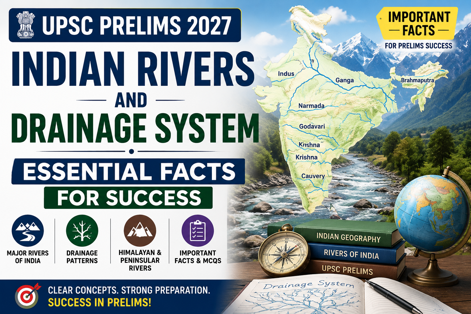
Indian Rivers and Drainage System UPSC Prelims 2027 is an important topic for understanding Indian Geography. Questions in UPSC Prelims can test river origins, tributaries, drainage patterns, river basins, direction of flow, and the geographical features associated with major rivers.
India’s drainage system is closely linked with its relief, geology, climate, and physiographic divisions. For examination purposes, Indian rivers are broadly classified into the Himalayan drainage system and the Peninsular drainage system.
This Indian Rivers and Drainage System UPSC Prelims 2027 guide covers the major river systems, tributaries, drainage patterns, and important facts relevant to the examination.
For more UPSC Prelims preparation resources, explore our Physical Geography of India UPSC MCQs 2027 for additional concepts and practice material.
What Is a Drainage System?
A drainage system refers to the network of rivers and streams through which water flows from a particular area.
The area drained by a river and its tributaries is known as its drainage basin or river basin.
A smaller stream that joins a larger river is called a tributary, while a channel that branches away from the main river, particularly in its lower course, is called a distributary.
The nature of drainage in India is strongly influenced by the country’s relief and geological structure.
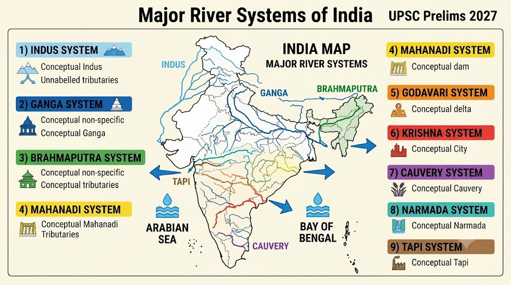
Indian Rivers and Drainage System: Major Drainage Systems of India
Indian rivers can broadly be divided into two major groups:
- Himalayan Rivers
- Peninsular Rivers
NCERT identifies the Indus, Ganga and Brahmaputra as the major Himalayan rivers and the Narmada, Tapi, Godavari, Mahanadi, Krishna and Kaveri among the major Peninsular rivers.
| Feature | Himalayan Rivers | Peninsular Rivers |
|---|---|---|
| Main source region | Himalayas and adjoining highlands | Peninsular Plateau and Western Ghats |
| Major rivers | Indus, Ganga, Brahmaputra | Godavari, Krishna, Kaveri, Mahanadi, Narmada, Tapi |
| Nature of flow | Generally perennial | Many are more seasonal |
| River valleys | Often deep and extensive | Generally shallower and more mature |
| Major work | Erosion and deposition | Mainly erosion, transport and deposition depending on course |
| Examples of major basins | Indus, Ganga, Brahmaputra | Godavari, Krishna, Mahanadi, Narmada |
Himalayan Drainage System
Understanding the Indian Rivers and Drainage System UPSC Prelims 2027 requires special attention to the three major Himalayan river systems: the Indus, Ganga and Brahmaputra.
The Himalayan drainage system is dominated by three major river systems:
- Indus
- Ganga
- Brahmaputra
These rivers are generally perennial because their water supply comes from both rainfall and snow/glacial melt.
The Peninsular part of the Indian Rivers and Drainage System UPSC Prelims 2027 is particularly important for questions related to river origins, direction of flow and drainage basins.
The Northern Plains were formed largely through the deposition of sediments brought by the Indus, Ganga and Brahmaputra river systems and their tributaries.
Indus River System
The Indus River rises in the Tibetan region near Lake Manasarovar and flows through the Ladakh region before entering Pakistan and eventually draining into the Arabian Sea.
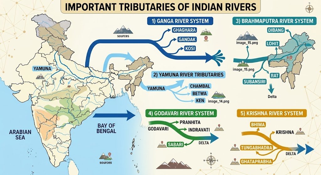
Its major tributaries include:
- Jhelum
- Chenab
- Ravi
- Beas
- Sutlej
Important Tributaries of the Indus
Jhelum:
The Jhelum rises in the Kashmir region and flows through the Kashmir Valley before entering Pakistan.
Chenab:
The Chenab is formed by the confluence of the Chandra and Bhaga rivers in Himachal Pradesh.
Ravi:
The Ravi rises in the Himalayas of Himachal Pradesh and flows towards Pakistan.
Beas:
The Beas rises in Himachal Pradesh and joins the Sutlej.
Sutlej:
The Sutlej originates in the Tibetan region and enters India through Himachal Pradesh.
UPSC Prelims Point
The five major rivers traditionally associated with the Punjab region are:
Jhelum + Chenab + Ravi + Beas + Sutlej
Ganga River System
The Ganga is one of the most important river systems of northern India.
The river is known as the Bhagirathi in its upper course and becomes the Ganga after the confluence of the Bhagirathi and Alaknanda at Devprayag in Uttarakhand.
Important tributaries of the Ganga include:
Major Left-Bank Tributaries
- Ramganga
- Gomti
- Ghaghara
- Gandak
- Kosi
Major Right-Bank Tributaries
- Yamuna
- Son
Yamuna River
The Yamuna originates from the Yamunotri Glacier in Uttarakhand.
It flows through the northern plains and joins the Ganga at Prayagraj.
Important tributaries of the Yamuna include:
- Chambal
- Betwa
- Ken
- Sind
Important Prelims Fact
The Chambal, Betwa and Ken are tributaries of the Yamuna, and therefore form part of the larger Ganga river system.
Brahmaputra River System
The Brahmaputra has an important transboundary course.
It is known as Yarlung Tsangpo in Tibet.
After entering India through Arunachal Pradesh, it is known as the Siang/Dihang in its upper course and subsequently becomes the Brahmaputra in Assam.
Important tributaries include:
- Dibang
- Lohit
- Subansiri
- Manas
The Brahmaputra is known for its large volume of water, braided channels and extensive floodplain in Assam.
Prelims Point
Remember the sequence:
Tibet → Yarlung Tsangpo → Arunachal Pradesh → Siang/Dihang → Brahmaputra in Assam
Peninsular Drainage System
The Peninsular rivers generally flow over an ancient and relatively stable landmass.
Major Peninsular rivers include:
- Godavari
- Krishna
- Kaveri
- Mahanadi
- Narmada
- Tapi
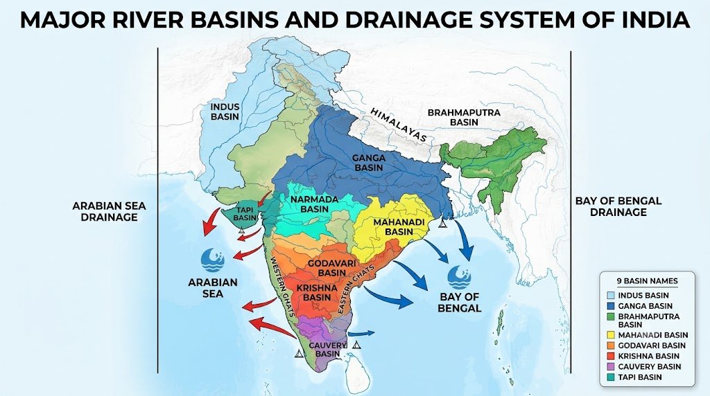
They can broadly be divided according to their direction of flow.
East-Flowing Peninsular Rivers
Important examples are:
- Mahanadi
- Godavari
- Krishna
- Kaveri
Most major east-flowing Peninsular rivers drain into the Bay of Bengal.
West-Flowing Peninsular Rivers
Important examples include:
- Narmada
- Tapi
These rivers drain into the Arabian Sea.
There are also several smaller west-flowing coastal rivers that independently drain into the Arabian Sea. India-WRIS, for example, documents several such independent west-flowing rivers along the western coast. (India Water Resources Information System)
Godavari River
The Godavari is the largest Peninsular river basin of India.
It originates in Maharashtra and flows generally eastward before entering the Bay of Bengal.
Important tributaries include:
- Pranhita
- Indravati
- Sabari
- Manjira
UPSC Prelims Point
The Godavari is often called the Dakshin Ganga because of its importance and extensive basin in Peninsular India.
Krishna River
The Krishna River rises near Mahabaleshwar in Maharashtra.
It flows eastward and eventually drains into the Bay of Bengal.
Important tributaries include:
- Bhima
- Tungabhadra
- Ghataprabha
- Malaprabha
- Musi
Kaveri River
The Kaveri originates at Talakaveri in the Brahmagiri Hills of Karnataka.
It flows through Karnataka and Tamil Nadu before entering the Bay of Bengal.
Important tributaries include:
- Kabini
- Hemavati
- Bhavani
- Amaravati
The Kaveri basin is particularly important for understanding the geography of southern India and inter-state water-resource issues.
Mahanadi River
The Mahanadi originates in the highlands of Chhattisgarh and flows through Chhattisgarh and Odisha before draining into the Bay of Bengal.
Its important tributaries include:
- Seonath
- Hasdeo
- Mand
- Ib
- Ong
- Tel
The river forms an important deltaic region along the Odisha coast.
Narmada River
The Narmada originates near Amarkantak in Madhya Pradesh.
It flows westward and drains into the Arabian Sea through the Gulf of Khambhat.
One of its important geographical characteristics is that it flows through a rift valley between the Vindhya Range to the north and the Satpura Range to the south.
Prelims Point
Narmada → west-flowing → Arabian Sea → rift valley
Tapi (Tapti) River
The Tapi originates in the Satpura Range in Madhya Pradesh.
It flows westward through Maharashtra and Gujarat before entering the Arabian Sea.
Like the Narmada, it is an important west-flowing Peninsular river.
Quick Comparison
| River | Direction | Drainage |
|---|---|---|
| Narmada | West | Arabian Sea |
| Tapi | West | Arabian Sea |
| Godavari | East | Bay of Bengal |
| Krishna | East | Bay of Bengal |
| Kaveri | East | Bay of Bengal |
| Mahanadi | East | Bay of Bengal |
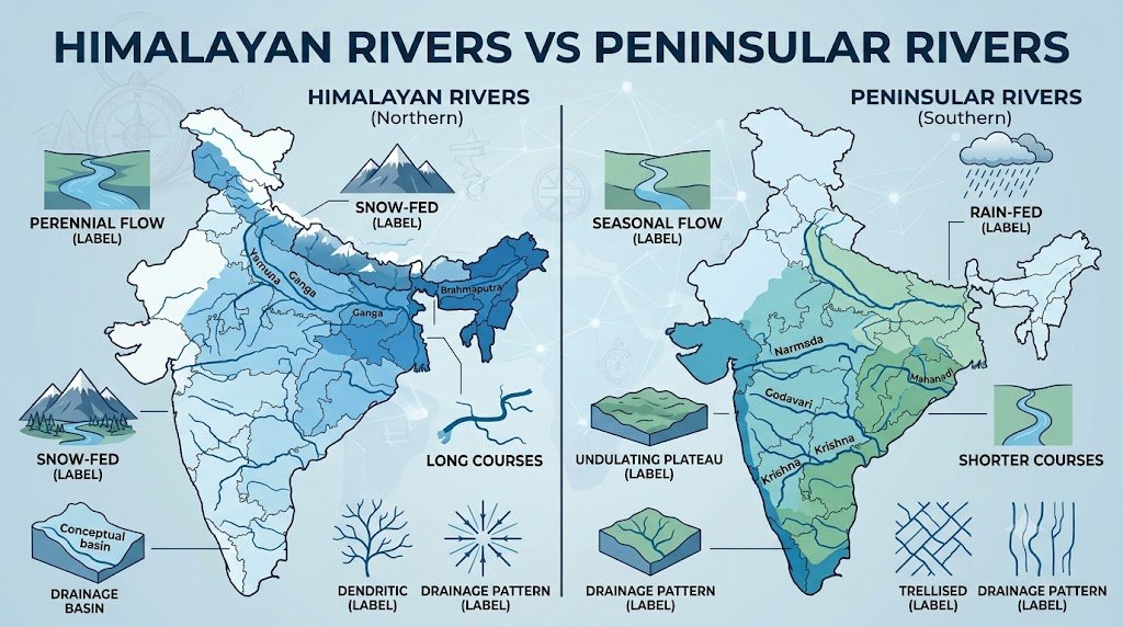
Himalayan Rivers vs Peninsular Rivers
This comparison is particularly useful for UPSC Prelims.
| Basis | Himalayan Rivers | Peninsular Rivers |
|---|---|---|
| Geological setting | Young mountain region and associated plains | Ancient Peninsular plateau |
| Major examples | Indus, Ganga, Brahmaputra | Godavari, Krishna, Kaveri, Mahanadi, Narmada |
| Water availability | Generally perennial | Many show stronger seasonal variation |
| Course | Often long and extensive | Generally shorter, with some major exceptions |
| Major drainage direction | Varies by river system | Many major rivers flow east |
| Delta formation | Important in lower courses | Major east-flowing rivers form deltas |
| Valley characteristics | Deep valleys and gorges in upper courses | Mature valleys and structural influence in many areas |
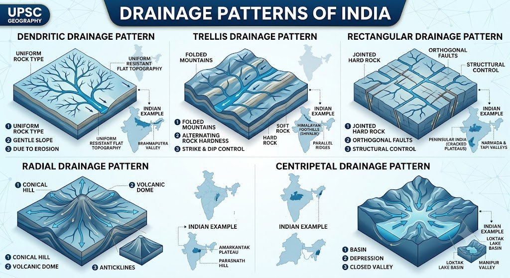
Drainage Patterns in India
A drainage pattern refers to the arrangement of streams and rivers in a drainage basin.
The pattern is influenced by:
- Rock structure
- Geological history
- Relief
- Slope
- Resistance of rocks
1. Dendritic Drainage
The tributaries branch out like the branches of a tree.
It commonly develops where the underlying rock structure is relatively uniform.
Prelims keyword: Tree-like pattern.
2. Trellis Drainage
In a trellis pattern, the main river flows approximately parallel to resistant rock structures, while tributaries join it at roughly right angles.
Prelims keyword: Alternating resistant and less-resistant rock structures.
3. Rectangular Drainage
The streams show a pattern with approximately right-angle bends.
It is commonly associated with areas having joints or faults in the underlying rocks.
4. Radial Drainage
In a radial pattern, rivers flow outward from a central elevated area.
Prelims keyword: Dome or elevated landform.
5. Centripetal Drainage
In this pattern, rivers flow inward toward a central depression or basin.
Prelims keyword: Internal drainage/depression.
Inland Drainage in India
Not all rivers in India reach the sea.
In parts of western Rajasthan, some streams drain into inland depressions or lakes rather than reaching the ocean.
The Luni is an important example of a river associated with the inland drainage region of western Rajasthan, although its drainage ultimately extends towards the Rann of Kachchh.
Prelims Tip
Do not assume that every Indian river drains directly into the Arabian Sea or Bay of Bengal.
Drainage Basin and Water Divide
Drainage Basin
The area drained by a river and its tributaries is called its drainage basin.
Water Divide
An elevated area separating two drainage basins is called a water divide.
For example, a mountain ridge can separate the drainage basins of two major rivers.
Important River Terms for UPSC Prelims
| Term | Meaning |
|---|---|
| Tributary | A smaller river/stream that joins a larger river |
| Distributary | A channel that branches away from the main river |
| Drainage Basin | Area drained by a river and its tributaries |
| Water Divide | Elevated land separating drainage basins |
| Delta | Depositional landform formed near a river mouth |
| Estuary | Funnel-shaped tidal river mouth |
| Meander | Curved bend in a river |
| Ox-bow Lake | Cut-off meander forming a lake |
| Floodplain | Flat land formed by river deposition |
| Doab | Land between two rivers |
Delta vs Estuary
This is a common area for conceptual questions.
Delta
A delta develops where a river deposits sediments near its mouth.
Examples include the deltas associated with major east-flowing rivers such as the Ganga-Brahmaputra, Mahanadi, Godavari, Krishna and Kaveri.
Estuary
An estuary is a funnel-shaped river mouth influenced strongly by tides.
Major west-flowing rivers such as the Narmada and Tapi are associated with estuarine mouths.
Prelims Shortcut
East-flowing major Peninsular rivers → generally delta-forming
Narmada/Tapi → estuarine mouths
Important River-Based Facts for UPSC Prelims
These are some of the most important Indian Rivers and Drainage System for UPSC Prelims 2027 facts to revise before the examination.
While attempting MCQs, remember these high-value facts:
- Indus, Ganga and Brahmaputra are the major Himalayan river systems.
- The Ganga is formed after the Bhagirathi meets the Alaknanda at Devprayag.
- Yamuna joins the Ganga at Prayagraj.
- Chambal, Betwa and Ken are tributaries of the Yamuna.
- The Brahmaputra is known as Yarlung Tsangpo in Tibet.
- Godavari is the largest Peninsular river basin.
- Narmada and Tapi are major west-flowing Peninsular rivers.
- Narmada flows through a rift valley.
- Major east-flowing Peninsular rivers generally drain into the Bay of Bengal.
- The Indus system includes Jhelum, Chenab, Ravi, Beas and Sutlej.
- A tributary joins the main river.
- A distributary branches away from the main river.
- A water divide separates drainage basins.
- A dendritic pattern resembles the branching structure of a tree.
- A radial pattern develops around an elevated central area.
- The Northern Plains were formed largely by alluvial deposition associated with the Indus, Ganga and Brahmaputra systems.
- The Luni is associated with the inland drainage region of western Rajasthan.
- The Kaveri originates in the Brahmagiri Hills.
- The Krishna originates near Mahabaleshwar.
- The Mahanadi drains through Chhattisgarh and Odisha.
30 MCQs on Indian Rivers and Drainage System UPSC Prelims
Test your understanding of the Indian Rivers and Drainage System with these UPSC Prelims-oriented multiple-choice questions. The questions focus on river systems, tributaries, drainage patterns, origins, direction of flow, and important geographical concepts.
Question 1
Which of the following is a major Himalayan river system?
A. Godavari
B. Krishna
C. Ganga
D. Kaveri
Answer: C. Ganga
Explanation: The Ganga is one of the three major Himalayan river systems, along with the Indus and Brahmaputra.
Question 2
The Ganga is known by the name Bhagirathi before:
A. Haridwar
B. Devprayag
C. Prayagraj
D. Rishikesh
Answer: B. Devprayag
Explanation: The Bhagirathi and Alaknanda meet at Devprayag. Downstream of this confluence, the river is known as the Ganga.
Question 3
Consider the following rivers:
- Chambal
- Betwa
- Ken
Which of the rivers given above are tributaries of the Yamuna?
A. 1 only
B. 1 and 2 only
C. 2 and 3 only
D. 1, 2 and 3
Answer: D. 1, 2 and 3
Explanation: Chambal, Betwa and Ken are important tributaries of the Yamuna.
Question 4
The Brahmaputra is known by which name in Tibet?
A. Siang
B. Yarlung Tsangpo
C. Lohit
D. Dihang
Answer: B. Yarlung Tsangpo
Explanation: The river is known as the Yarlung Tsangpo in Tibet. After entering Arunachal Pradesh, it is known by different names before becoming the Brahmaputra in Assam.
Question 5
Which of the following rivers is a major west-flowing Peninsular river?
A. Godavari
B. Krishna
C. Narmada
D. Kaveri
Answer: C. Narmada
Explanation: The Narmada flows westward through a rift valley and drains into the Arabian Sea.
Question 6
Which of the following rivers originates near Mahabaleshwar?
A. Krishna
B. Godavari
C. Kaveri
D. Tapi
Answer: A. Krishna
Explanation: The Krishna River rises near Mahabaleshwar in Maharashtra and flows generally eastward towards the Bay of Bengal.
Question 7
Which of the following has the largest river basin among the Peninsular rivers of India?
A. Krishna
B. Godavari
C. Kaveri
D. Mahanadi
Answer: B. Godavari
Explanation: The Godavari has the largest river basin among India’s Peninsular river systems.
Question 8
The Narmada River is particularly associated with:
A. A deltaic course throughout its length
B. A rift valley
C. A glacial valley throughout its course
D. An inland drainage basin
Answer: B. A rift valley
Explanation: The Narmada flows through a structural rift valley between the Vindhya Range to the north and the Satpura Range to the south.
Question 9
Which drainage pattern resembles the branches of a tree?
A. Radial
B. Trellis
C. Dendritic
D. Centripetal
Answer: C. Dendritic
Explanation: A dendritic drainage pattern develops where the underlying rock structure does not significantly control the direction of drainage, producing a tree-like pattern.
Question 10
A drainage pattern in which streams flow outward from a central elevated area is known as:
A. Radial
B. Centripetal
C. Trellis
D. Rectangular
Answer: A. Radial
Explanation: Radial drainage develops when rivers flow outward from a central elevated feature such as a dome or volcanic cone.
Question 11
Which river is associated with the inland drainage region of western Rajasthan?
A. Luni
B. Narmada
C. Tapi
D. Mahi
Answer: A. Luni
Explanation: The Luni is an important river of western Rajasthan and is associated with the region’s inland drainage. Its drainage extends towards the Rann of Kachchh.
Question 12
Which of the following is NOT a major tributary of the Indus River system?
A. Jhelum
B. Ravi
C. Beas
D. Yamuna
Answer: D. Yamuna
Explanation: Yamuna is an important tributary of the Ganga through its confluence with the Ganga at Prayagraj. Jhelum, Ravi and Beas belong to the Indus system.
Question 13
Which river joins the Ganga at Prayagraj?
A. Yamuna
B. Ghaghara
C. Gandak
D. Kosi
Answer: A. Yamuna
Explanation: The Yamuna joins the Ganga at Prayagraj, forming an important river confluence.
Question 14
Consider the following rivers:
- Narmada
- Tapi
- Godavari
Which of the above flow into the Arabian Sea?
A. 1 only
B. 1 and 2 only
C. 2 and 3 only
D. 1, 2 and 3
Answer: B. 1 and 2 only
Explanation: Narmada and Tapi are major west-flowing rivers that drain into the Arabian Sea. Godavari flows eastward into the Bay of Bengal.
Question 15
Which of the following is an east-flowing Peninsular river?
A. Tapi
B. Narmada
C. Godavari
D. Sabarmati
Answer: C. Godavari
Explanation: The Godavari flows generally eastward and drains into the Bay of Bengal.
Question 16
A smaller river or stream that joins a larger river is called a:
A. Distributary
B. Tributary
C. Water divide
D. Estuary
Answer: B. Tributary
Explanation: A tributary contributes its flow to a larger river or stream.
Question 17
A channel that branches away from the main river, particularly in its lower course, is called a:
A. Tributary
B. Water divide
C. Distributary
D. Meander
Answer: C. Distributary
Explanation: Distributaries branch away from the main river channel and are commonly found in deltaic regions.
Question 18
Which of the following rivers belongs to the Peninsular drainage system?
A. Brahmaputra
B. Ganga
C. Godavari
D. Yamuna
Answer: C. Godavari
Explanation: The Godavari is a major Peninsular river and one of India’s largest river basins.
Question 19
The Kaveri River originates in:
A. Maharashtra
B. Karnataka
C. Chhattisgarh
D. Madhya Pradesh
Answer: B. Karnataka
Explanation: The Kaveri originates at Talakaveri in the Brahmagiri Hills of Karnataka.
Question 20
Which of the following is an important tributary of the Godavari?
A. Indravati
B. Yamuna
C. Ravi
D. Beas
Answer: A. Indravati
Explanation: Indravati is an important tributary of the Godavari River system.
Question 21
Which of the following is an important tributary of the Krishna River?
A. Bhima
B. Kosi
C. Gandak
D. Ravi
Answer: A. Bhima
Explanation: Bhima is one of the important tributaries of the Krishna River.
Question 22
The Mahanadi primarily flows through:
A. Punjab and Haryana
B. Chhattisgarh and Odisha
C. Gujarat and Rajasthan
D. Kerala and Tamil Nadu
Answer: B. Chhattisgarh and Odisha
Explanation: The Mahanadi originates in Chhattisgarh and flows through Odisha before entering the Bay of Bengal.
Question 23
Which pair consists of major west-flowing Peninsular rivers?
A. Krishna and Kaveri
B. Godavari and Mahanadi
C. Narmada and Tapi
D. Ganga and Yamuna
Answer: C. Narmada and Tapi
Explanation: Narmada and Tapi are the two major west-flowing Peninsular rivers that drain into the Arabian Sea.
Question 24
A drainage pattern in which streams flow towards a central depression is called:
A. Radial
B. Centripetal
C. Dendritic
D. Trellis
Answer: B. Centripetal
Explanation: In a centripetal drainage pattern, streams converge towards a central depression or basin.
Question 25
A water divide is:
A. The mouth of a river
B. A tributary of a river
C. An elevated area separating two drainage basins
D. An island formed by river deposition
Answer: C. An elevated area separating two drainage basins
Explanation: A water divide separates the drainage systems of two different river basins.
Question 26
Which of the following rivers is part of the Indus River system?
A. Sutlej
B. Son
C. Gomti
D. Kosi
Answer: A. Sutlej
Explanation: Sutlej is one of the major tributaries of the Indus River system.
Question 27
Which river systems played the most important role in the formation of the Northern Plains?
A. Narmada-Tapi
B. Indus-Ganga-Brahmaputra
C. Godavari-Krishna
D. Kaveri-Mahanadi
Answer: B. Indus-Ganga-Brahmaputra
Explanation: The Northern Plains were formed largely through the deposition of sediments brought by the Indus, Ganga and Brahmaputra systems and their tributaries.
Question 28
Which of the following pairs is correctly matched?
A. Narmada — Bay of Bengal
B. Godavari — Arabian Sea
C. Tapi — Arabian Sea
D. Kaveri — Arabian Sea
Answer: C. Tapi — Arabian Sea
Explanation: Tapi is a major west-flowing Peninsular river that drains into the Arabian Sea.
Question 29
Which of the following pairs is correctly matched?
A. Krishna — Mahabaleshwar
B. Kaveri — Amarkantak
C. Narmada — Mahabaleshwar
D. Godavari — Brahmagiri Hills
Answer: A. Krishna — Mahabaleshwar
Explanation: The Krishna River rises near Mahabaleshwar in Maharashtra.
Question 30
Consider the following statements:
- Narmada is a west-flowing river.
- Godavari is an east-flowing river.
- Tapi is a west-flowing river.
Which of the statements given above are correct?
A. 1 only
B. 1 and 2 only
C. 2 and 3 only
D. 1, 2 and 3
Answer: D. 1, 2 and 3
Explanation: Narmada and Tapi flow westward into the Arabian Sea, while Godavari flows eastward into the Bay of Bengal.
Frequently Asked Questions
1. Which are the major river systems of India?
The major river systems include the Indus, Ganga, Brahmaputra, Godavari, Krishna, Mahanadi, Kaveri, Narmada and Tapi.
2 Which is the largest Peninsular river basin?
The Godavari has the largest Peninsular river basin.
3. Which major rivers flow westward?
The Narmada and Tapi are the two major west-flowing Peninsular rivers.
4. Which river system forms much of the Northern Plains?
The Indus, Ganga and Brahmaputra systems, along with their tributaries, played a major role in forming the Northern Plains.
5. What is the difference between a tributary and a distributary?
A tributary joins the main river, while a distributary branches away from the main river.
6. Why are rivers important for UPSC Prelims?
River-related questions can combine physical geography, mapping, agriculture, water resources, drainage patterns, interstate water issues and environmental geography, making river systems an important area of Indian Geography preparation.
How to Prepare Indian Rivers for UPSC Prelims
Do not try to memorize rivers as isolated facts. Prepare them through map-based revision.
For every major river, remember:
Source → Course → Tributaries → States/regions → Direction → Drainage basin → Mouth → Important geographical features
For example:
Narmada → Amarkantak → westward → rift valley → Arabian Sea
This approach makes it easier to solve statement-based and map-based questions.
Conclusion
The Indian Rivers and Drainage System UPSC Prelims 2027 is best studied by connecting physical geography with maps and river-basin relationships.
The most important areas for revision are the Indus, Ganga and Brahmaputra systems; major Peninsular rivers; east-flowing and west-flowing rivers; tributaries; drainage patterns; drainage basins; and important river-based geographical features.
A systematic understanding of the Indian Rivers and Drainage System UPSC Prelims 2027 can help aspirants solve both direct and statement-based Geography questions.
For effective Prelims preparation, revise these topics repeatedly with an outline map of India and practice statement-based MCQs rather than relying only on rote memorization.
📚 Suggested Further Reading
For foundational Geography preparation, NCERT’s Geography textbooks remain a useful starting point. The official NCERT textbook portal provides access to the relevant Geography texts.
6 thoughts on “Indian Rivers and Drainage System UPSC Prelims 2027: Important Facts for Success”