Himalayan Rivers are among the most important areas of Indian Geography for UPSC CSE Prelims. Questions are rarely limited to simple facts such as the source or tributary of a river. UPSC has repeatedly tested river systems through statements, source–course–confluence relationships, geographical sequencing, river–lake associations, drainage characteristics and identification based on multiple clues.
This Himalayan Rivers UPSC Prelims 2027 practice set is designed to strengthen conceptual understanding, geographical mapping and statement-based elimination skills.
After attempting these questions, candidates should revise the basic concepts covered in Geography for UPSC Prelims and then test their understanding through statement-based MCQs.
The official UPSC archive provides the Civil Services Preliminary General Studies papers, including the 2026 General Studies Paper I, while the Commission’s previous-question-paper archive provides earlier papers for comparison.
What Actual UPSC Questions Tell Us About Himalayan Rivers
The recent pattern is particularly useful for designing a 2027 practice set.
In 2017, UPSC tested the Teesta through three statements involving its source, the Rangeet and its downstream course.
In 2023, UPSC used relationships between rivers and lakes, including the Jhelum–Wular connection and the relationship between the Gandak system and Kanwar Lake. The question demonstrates how UPSC can turn a seemingly simple river fact into a carefully worded statement-based question.
In 2024, UPSC asked candidates to arrange the Himalayan rivers joining the Ganga downstream of Prayagraj from west to east. This is an excellent example of UPSC testing spatial understanding rather than isolated memorisation.
The 2026 Prelims paper is also officially available through UPSC, and contemporary analysis of the paper identifies river-system questions that rely on multiple clues such as antecedent drainage, countries traversed, Tibetan origin and river characteristics.
Therefore, the questions below deliberately emphasise:
Statement-based reasoning + river systems + tributaries + source and course + confluences + spatial sequence + drainage characteristics + geographical concepts + elimination-based options.
The questions are original practice questions, not copied UPSC questions.
The Himalayan Rivers UPSC Prelims 2027 approach used here closely follows these recurring patterns rather than relying on simple one-line factual questions.
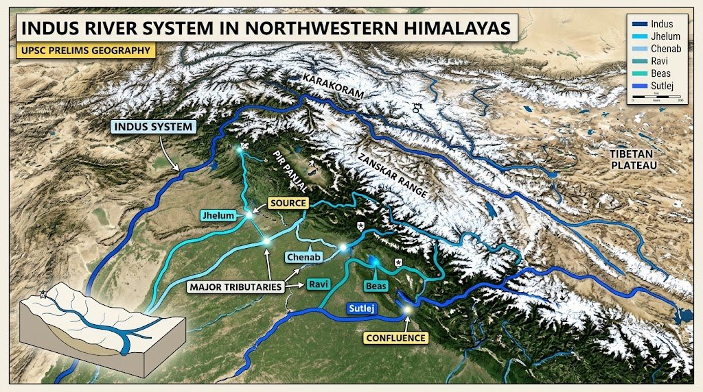
Section 1: Indus River System and Western Himalayan Rivers
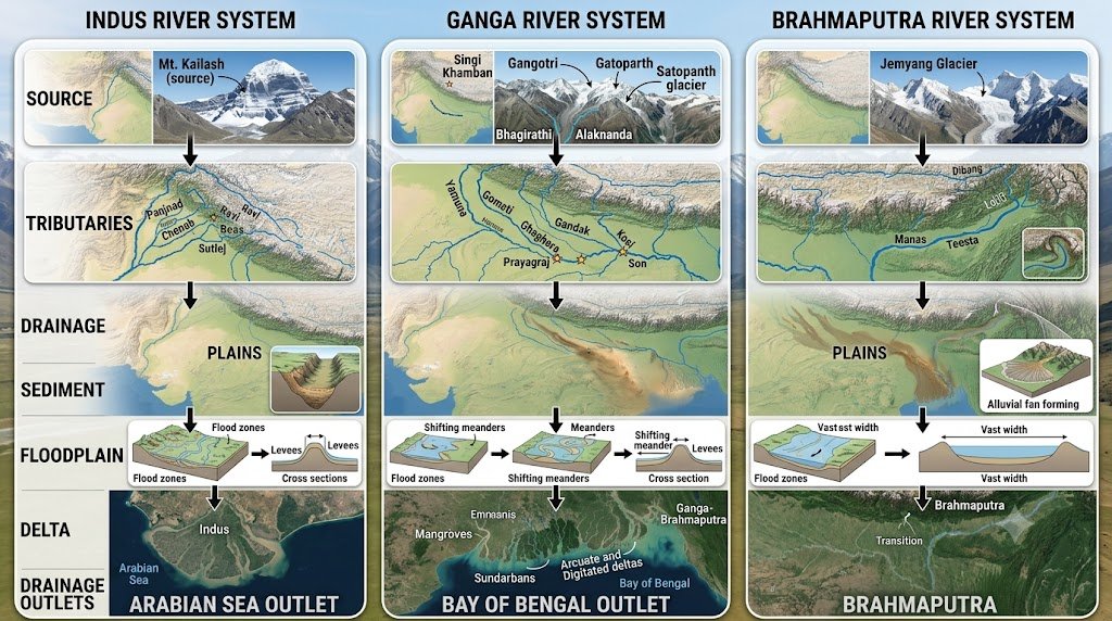
While doing Himalayan Rivers UPSC Prelims 2027 practice, refer the major drainage divisions of the Indus, Ganga and Brahmaputra systems on a map.
- Consider the following statements regarding the Indus River System:
- The Indus rises in the Tibetan Plateau and enters India in the Union Territory of Ladakh.
- The river flows generally towards the west before emptying into the Arabian Sea.
- All the major tributaries of the Indus originate within Indian territory.
Which of the statements given above is/are correct?
(a) 1 and 2 only
(b) 2 only
(c) 1 and 3 only
(d) 1, 2 and 3
- With reference to the Jhelum River, consider the following statements:
- It rises from a spring at Verinag.
- It passes through the Wular Lake.
- It joins the Chenab in Pakistan.
Which of the statements given above is/are correct?
(a) 1 only
(b) 1 and 2 only
(c) 2 and 3 only
(d) 1, 2 and 3
- Consider the following pairs:
River — Important geographical association
- Jhelum — Wular Lake
- Beas — Harike
- Sutlej — Shipki La
How many of the above pairs are correctly matched?
(a) Only one
(b) Only two
(c) All three
(d) None
- Consider the following statements regarding the Chenab River:
- It is formed by the confluence of the Chandra and Bhaga rivers.
- The confluence takes place near Tandi in Himachal Pradesh.
- It joins the Ravi directly before entering Pakistan.
Which of the statements given above is/are correct?
(a) 1 and 2 only
(b) 1 only
(c) 2 and 3 only
(d) 1, 2 and 3
- Which one of the following sequences correctly represents the five major tributaries of the Indus system in the conventional west-to-east arrangement in the Indian subcontinent?
(a) Jhelum – Chenab – Ravi – Beas – Sutlej
(b) Jhelum – Ravi – Chenab – Beas – Sutlej
(c) Chenab – Jhelum – Ravi – Sutlej – Beas
(d) Ravi – Jhelum – Chenab – Beas – Sutlej
- With reference to the Beas River, consider the following statements:
- It originates near Beas Kund.
- It joins the Sutlej in Punjab.
- It is the westernmost major tributary of the Indus system.
Which of the statements given above is/are correct?
(a) 1 and 2 only
(b) 2 only
(c) 1 and 3 only
(d) 1, 2 and 3
- Consider the following rivers:
- Jhelum
- Chenab
- Ravi
- Beas
- Sutlej
How many of the above are tributaries of the Indus?
(a) Only two
(b) Only three
(c) Only four
(d) All five
- With reference to the Sutlej River, consider the following statements:
- It rises in the Tibetan region near the Kailash–Mansarovar area.
- It enters India through the Shipki La region.
- It is a tributary of the Yamuna.
Which of the statements given above is/are correct?
(a) 1 and 2 only
(b) 2 only
(c) 1 and 3 only
(d) 1, 2 and 3
- Consider the following statements:
- The Jhelum is associated with the Kashmir Valley.
- The Chenab is formed by the union of the Chandra and Bhaga.
- The Beas joins the Ravi before the Ravi enters Pakistan.
Which of the statements given above is/are correct?
(a) 1 and 2 only
(b) 2 and 3 only
(c) 1 only
(d) 1, 2 and 3
- Which one of the following rivers is correctly matched with the place where it joins another major river?
(a) Beas — Harike — Sutlej
(b) Jhelum — Prayagraj — Ganga
(c) Ravi — Devprayag — Ganga
(d) Sutlej — Sonpur — Ganga
- Consider the following statements about the Indus River system:
- The Indus and its tributaries have a drainage basin extending across more than one country.
- The river system is important for irrigation in the north-western part of the Indian subcontinent.
- The Indus finally drains into the Bay of Bengal.
Which of the statements given above is/are correct?
(a) 1 and 2 only
(b) 1 only
(c) 2 and 3 only
(d) 1, 2 and 3
- Which one of the following rivers is a tributary of the Chenab?
(a) Tawi
(b) Baspa
(c) Spiti
(d) Wangchu
- Consider the following pairs:
- Chandra — Chenab
- Bhaga — Chenab
- Beas — Sutlej
- Jhelum — Chenab
How many of the above pairs are correctly matched in terms of the lower-order river joining the stated major river?
(a) Only one
(b) Only two
(c) Only three
(d) All four
- With reference to Himalayan river valleys in the western Himalayas, which one of the following statements is most appropriate?
(a) They are exclusively dependent on monsoon rainfall.
(b) Their flow is sustained by both snow and glacier melt as well as precipitation.
(c) They are generally seasonal because Himalayan snowfall does not affect river discharge.
(d) Their discharge remains almost unchanged throughout the year.
- Consider the following statements regarding the Indus system:
- The Sutlej is one of the easternmost major tributaries of the Indus.
- The Beas joins the Sutlej before the combined flow proceeds towards Pakistan.
- The Ravi is a tributary of the Ganga.
Which of the statements given above is/are correct?
(a) 1 and 2 only
(b) 2 and 3 only
(c) 1 only
(d) 1, 2 and 3
- Which one of the following is the best explanation for the existence of deep gorges cut by some Himalayan rivers across mountain ranges?
(a) The rivers are generally antecedent and maintained their courses while the mountains were rising.
(b) The rivers originated after the Himalayas and therefore followed the weakest rocks.
(c) Himalayan rivers are entirely dependent on groundwater.
(d) The rivers flowed only through fault valleys created after the formation of the Himalayas.
- Consider the following statements:
- The Indus originates north of the main Himalayan range.
- The Sutlej also has its source in the Tibetan Plateau.
- The Yamuna originates in Tibet and enters India through Ladakh.
Which of the statements given above is/are correct?
(a) 1 and 2 only
(b) 2 and 3 only
(c) 1 only
(d) 1, 2 and 3
- Which one of the following river–lake pairs is correctly matched?
(a) Jhelum — Wular
(b) Chenab — Dal
(c) Ravi — Pangong
(d) Sutlej — Sambhar
- Consider the following statements:
- The five major rivers traditionally associated with Punjab are Jhelum, Chenab, Ravi, Beas and Sutlej.
- All five ultimately form part of the Indus drainage system.
- All five rivers flow entirely within Indian territory.
Which of the statements given above is/are correct?
(a) 1 and 2 only
(b) 2 and 3 only
(c) 1 only
(d) 1, 2 and 3
- Which one of the following best distinguishes the Jhelum from the Sutlej?
(a) Jhelum is associated with the Kashmir Valley, whereas Sutlej cuts across the Himalayas after rising in Tibet.
(b) Jhelum flows into the Bay of Bengal, whereas Sutlej flows into the Arabian Sea.
(c) Jhelum is a tributary of the Ganga, whereas Sutlej is a tributary of the Yamuna.
(d) Jhelum originates in Nepal, whereas Sutlej originates in Bhutan.
A strong understanding of the Indus River System is essential for solving UPSC Geography questions based on sources, tributaries, drainage patterns and spatial relationships.
Answers & Explanations: Section 1 of Himalayan Rivers UPSC Prelims 2027: 100 High-Quality MCQs
- (a) — The Indus rises in the Tibetan Plateau, enters Ladakh and eventually drains into the Arabian Sea. Its tributaries also originate outside India, so statement 3 is incorrect.
- (d) — The Jhelum rises at Verinag, passes through Wular Lake and later joins the Chenab in Pakistan.
- (c) — Wular is associated with Jhelum; the Beas joins the Sutlej at Harike; Sutlej enters India through the Shipki La region.
- (a) — Chenab is formed by the Chandra and Bhaga at Tandi. It does not join the Ravi directly.
- (a) — The conventional sequence is Jhelum, Chenab, Ravi, Beas and Sutlej from west to east.
- (a) — Beas rises near Beas Kund and joins the Sutlej at Harike. It is not the westernmost major tributary of the Indus system.
- (d) — All five rivers form part of the Indus drainage system.
- (a) — Sutlej rises in the Tibetan region, enters India through the Shipki La region and ultimately belongs to the Indus system.
- (a) — Statements 1 and 2 are correct. Beas joins the Sutlej, not the Ravi.
- (a) — Beas joins the Sutlej at Harike in Punjab.
- (a) — The Indus basin is international, supports extensive irrigation and ultimately drains into the Arabian Sea.
- (a) — Tawi is associated with the Chenab system. Baspa and Spiti are associated with the Sutlej system.
- (d) — Chandra and Bhaga form the Chenab; Beas joins Sutlej; Jhelum joins Chenab.
- (b) — Himalayan rivers are generally perennial because their discharge is supported by both precipitation and snow/glacier melt.
- (a) — Sutlej is an eastern tributary of the Indus and receives the Beas. Ravi belongs to the Indus system, not Ganga.
- (a) — Antecedent rivers are older than the major uplift and can maintain their courses while mountain ranges rise.
- (a) — Indus and Sutlej have Tibetan origins. Yamuna originates in Uttarakhand.
- (a) — Jhelum passes through Wular Lake.
- (a) — The five traditional Punjab rivers belong to the Indus system, but several flow into or through Pakistan, so statement 3 is incorrect.
- (a) — Jhelum is closely associated with the Kashmir Valley; Sutlej rises in Tibet and cuts across the Himalayas into India.
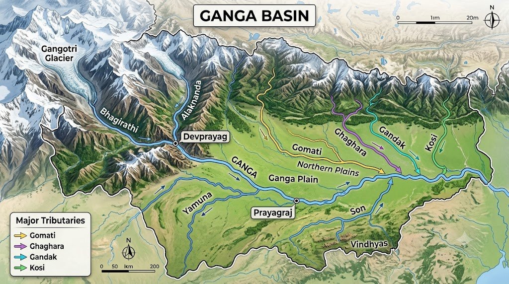
Section 2: Ganga River System and Its Himalayan Tributaries
In Himalayan Rivers UPSC Prelims 2027 preparation, the Ganga system should be studied through its source streams, tributaries, confluences and west-to-east arrangement.
- Consider the following statements regarding the Ganga:
- The Ganga is formed at Devprayag by the confluence of the Bhagirathi and Alaknanda.
- The Bhagirathi originates from the Gangotri Glacier.
- The Alaknanda has no major tributaries before joining the Bhagirathi.
Which of the statements given above is/are correct?
(a) 1 and 2 only
(b) 2 only
(c) 1 and 3 only
(d) 1, 2 and 3
- With reference to the Alaknanda River, consider the following statements:
- It is one of the two streams whose confluence at Devprayag gives rise to the Ganga.
- The Mandakini is a tributary of the Alaknanda.
- The Pindar is part of the Alaknanda river system.
Which of the statements given above is/are correct?
(a) 1 only
(b) 1 and 2 only
(c) 2 and 3 only
(d) 1, 2 and 3
- Which one of the following pairs is correctly matched?
(a) Yamuna — Yamunotri Glacier
(b) Ghaghara — Gangotri Glacier
(c) Gandak — Yamunotri
(d) Kosi — Nanda Devi Glacier
- Consider the following statements about the Yamuna:
- It originates from the Yamunotri region.
- It joins the Ganga at Prayagraj.
- Chambal, Betwa and Ken are important tributaries of the Yamuna system.
Which of the statements given above is/are correct?
(a) 1 and 2 only
(b) 2 and 3 only
(c) 1 and 3 only
(d) 1, 2 and 3
- Consider the following rivers:
- Gomati
- Ghaghara
- Gandak
- Kosi
Which of the above are major Himalayan tributaries joining the Ganga downstream of Prayagraj?
(a) 1 and 2 only
(b) 2 and 3 only
(c) 1, 2 and 3 only
(d) 1, 2, 3 and 4
- With reference to the Ganga basin, consider the following statements:
- The Gomati is a tributary of the Ganga.
- The Ghaghara enters India from the Himalayan region.
- The Son is a left-bank tributary of the Ganga.
Which of the statements given above is/are correct?
(a) 1 and 2 only
(b) 1 and 3 only
(c) 2 and 3 only
(d) 1, 2 and 3
- Which one of the following sequences correctly represents the major Himalayan tributaries joining the Ganga downstream of Prayagraj from west to east?
(a) Gomati – Ghaghara – Gandak – Kosi
(b) Ghaghara – Gomati – Gandak – Kosi
(c) Gomati – Ghaghara – Kosi – Gandak
(d) Gandak – Gomati – Ghaghara – Kosi
- Consider the following statements:
- The Ghaghara is a major tributary of the Ganga.
- The Gandak is also known as the Narayani in Nepal.
- The Kosi is often associated with a highly shifting channel system in its lower course.
Which of the statements given above is/are correct?
(a) 1 only
(b) 1 and 2 only
(c) 2 and 3 only
(d) 1, 2 and 3
- With reference to the Yamuna river system, consider the following pairs:
- Chambal — Yamuna
- Betwa — Yamuna
- Ken — Yamuna
- Son — Yamuna
How many of the above pairs are correctly matched?
(a) Only one
(b) Only two
(c) Only three
(d) All four
- Consider the following statements regarding the Son River:
- It is a right-bank tributary of the Ganga.
- It rises near the Amarkantak region.
- It is a major tributary of the Yamuna.
Which of the statements given above is/are correct?
(a) 1 and 2 only
(b) 2 only
(c) 1 and 3 only
(d) 1, 2 and 3
- Consider the following statements:
- The Gomati joins the Ganga downstream of Prayagraj.
- The Yamuna joins the Ganga at Prayagraj.
- The Son joins the Ganga in the vicinity of Patna.
Which of the statements given above is/are correct?
(a) 1 only
(b) 2 and 3 only
(c) 1 and 2 only
(d) 1, 2 and 3
- Which one of the following pairs of rivers and tributaries is correctly matched?
(a) Ganga — Gomati
(b) Yamuna — Gandak
(c) Brahmaputra — Son
(d) Indus — Kosi
- Consider the following statements about the Kosi:
- It drains a large part of the Himalayan region of Nepal before entering India.
- It is known for high sediment loads and channel shifting in the plains.
- It joins the Brahmaputra in Bangladesh.
Which of the statements given above is/are correct?
(a) 1 and 2 only
(b) 2 only
(c) 1 and 3 only
(d) 1, 2 and 3
- Which one of the following is an important characteristic of the Ganga river system?
(a) It is formed exclusively by rivers originating south of the Himalayas.
(b) It includes both snow-fed Himalayan tributaries and rivers draining the Peninsular uplands.
(c) It contains no tributary originating in the Peninsular Plateau.
(d) It is entirely a trans-Himalayan drainage system.
- Consider the following statements regarding Himalayan tributaries of the Ganga:
- Many of them carry large quantities of sediment.
- Their courses in the plains are generally more stable than all major Peninsular rivers.
- Their flood behaviour can be influenced by both intense rainfall and upstream conditions in the mountains.
Which of the statements given above is/are correct?
(a) 1 and 3 only
(b) 1 and 2 only
(c) 2 and 3 only
(d) 1, 2 and 3
- Which one of the following is correctly matched?
(a) Devprayag — Bhagirathi and Alaknanda
(b) Prayagraj — Ganga and Ghaghara
(c) Haridwar — Ganga and Yamuna
(d) Patna — Ganga and Yamuna
- Consider the following statements:
- The Mandakini joins the Alaknanda.
- The Pindar joins the Alaknanda.
- The Bhagirathi joins the Alaknanda at Devprayag.
Which of the statements given above is/are correct?
(a) 1 only
(b) 1 and 2 only
(c) 2 and 3 only
(d) 1, 2 and 3
- The left-bank tributaries of the Ganga are especially important for understanding the Himalayan drainage because many of them:
(a) originate in the Himalayas and enter the Ganga from the north
(b) originate only in the Peninsular Plateau
(c) flow into the Arabian Sea
(d) form the upper course of the Narmada
- Consider the following statements:
- Gomati joins the Ganga west of Ghaghara.
- Gandak joins the Ganga west of Kosi.
- Kosi is generally the easternmost among the four major Himalayan tributaries listed above.
Which of the statements given above is/are correct?
(a) 1 only
(b) 1 and 2 only
(c) 2 and 3 only
(d) 1, 2 and 3
- Which one of the following best explains why the Ganga basin is suitable for intensive agriculture?
(a) It is dominated by exposed hard crystalline rocks.
(b) It contains extensive fertile alluvial plains, with substantial sediment deposition by rivers.
(c) It receives almost no seasonal rainfall.
(d) Its rivers have no floodplain development.
For broader revision, candidates can also practise Ultimate Physical Geography of India UPSC MCQs 2027 covering physical geography and important geographical features.
Answers & Explanations: Section 2 of Himalayan Rivers UPSC Prelims 2027: 100 High-Quality MCQs
- (a) — Bhagirathi and Alaknanda meet at Devprayag to form the Ganga, and Bhagirathi originates from the Gangotri Glacier region.
- (d) — Alaknanda is one of the two main streams forming the Ganga at Devprayag; Mandakini and Pindar are important tributaries of its system.
- (a) — Yamuna rises in the Yamunotri region. The other pairings are incorrect.
- (d) — All three statements are correct.
- (d) — Gomati, Ghaghara, Gandak and Kosi are all important Himalayan tributaries of the Ganga downstream of Prayagraj.
- (a) — Gomati and Ghaghara are correct. Son is a right-bank tributary, not a left-bank tributary.
- (a) — The west-to-east sequence is Gomati, Ghaghara, Gandak and Kosi.
- (d) — All three statements are correct.
- (c) — Chambal, Betwa and Ken are associated with the Yamuna system. Son is a tributary of the Ganga.
- (a) — Son is a right-bank Ganga tributary and rises near Amarkantak. It is not a Yamuna tributary.
- (d) — All three are correct. Gomati joins the Ganga downstream of Prayagraj; Yamuna joins at Prayagraj; Son joins the Ganga near Patna.
- (a) — Gomati is a tributary of the Ganga.
- (a) — Kosi drains the Himalayan region and is known for substantial sediment and channel migration. It joins the Ganga, not Brahmaputra.
- (b) — The Ganga basin contains Himalayan tributaries and also Peninsular tributaries such as the Son.
- (a) — Himalayan tributaries carry substantial sediment, and flood behaviour depends on both rainfall and upstream mountain conditions.
- (a) — Devprayag is the confluence of Bhagirathi and Alaknanda.
- (b) — Mandakini and Pindar join Alaknanda. At Devprayag, Bhagirathi joins Alaknanda.
- (a) — Many left-bank tributaries of the Ganga descend from the Himalayas and enter the Ganga from the north.
- (d) — Gomati lies west of Ghaghara; Gandak lies west of Kosi; Kosi is the easternmost of these four.
- (b) — Extensive alluvial deposition has produced fertile plains highly suitable for agriculture.
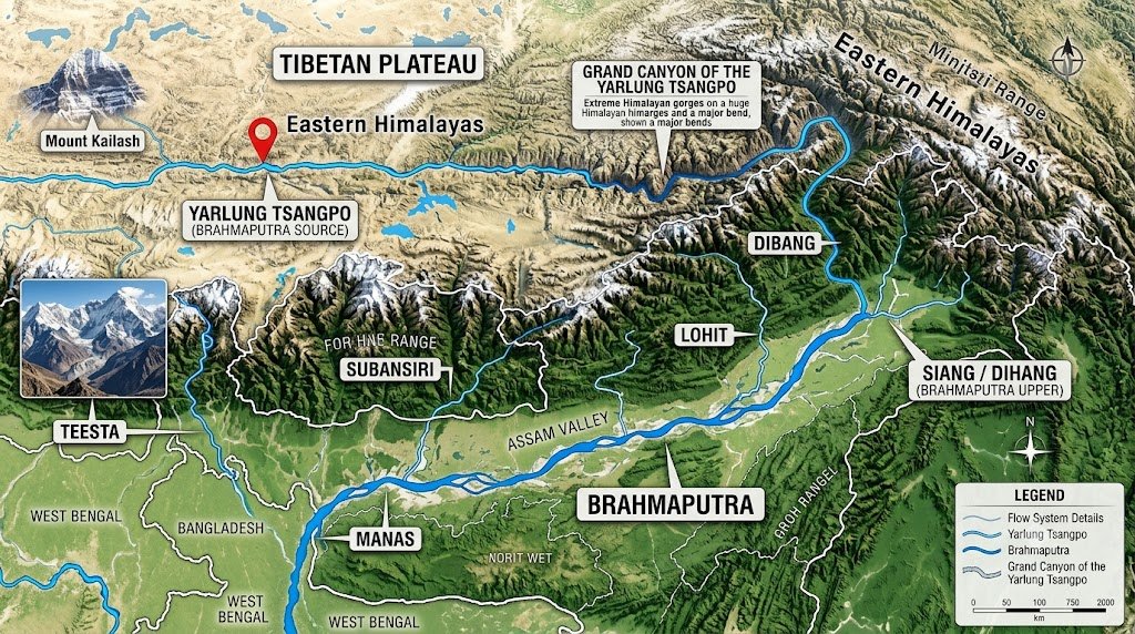
Section 3: Brahmaputra, Teesta and Eastern Himalayan Rivers
The Brahmaputra and Teesta are equally important for Himalayan Rivers UPSC Prelims 2027, particularly for questions based on river names, tributaries, geographical regions and international drainage.
- Consider the following statements regarding the Brahmaputra:
- It is known as the Yarlung Tsangpo in Tibet.
- It enters India through Arunachal Pradesh.
- It ultimately forms part of the Ganga-Brahmaputra-Meghna delta system.
Which of the statements given above is/are correct?
(a) 1 only
(b) 1 and 2 only
(c) 2 and 3 only
(d) 1, 2 and 3
- With reference to the Brahmaputra in Arunachal Pradesh, consider the following statements:
- It is associated with the name Siang or Dihang.
- Dibang and Lohit are important rivers joining its system.
- It immediately enters the Bay of Bengal after crossing Arunachal Pradesh.
Which of the statements given above is/are correct?
(a) 1 and 2 only
(b) 2 only
(c) 1 and 3 only
(d) 1, 2 and 3
- Consider the following pairs:
River — Association
- Lohit — Brahmaputra
- Dibang — Brahmaputra
- Subansiri — Brahmaputra
- Manas — Brahmaputra
How many of the above pairs are correctly matched?
(a) Only two
(b) Only three
(c) All four
(d) Only one
- Which one of the following is the most appropriate description of the Brahmaputra in Assam?
(a) A narrow, straight river with very little sediment load
(b) A highly braided river with a broad channel and considerable sediment deposition
(c) A short seasonal stream confined to a rift valley
(d) A west-flowing river draining directly into the Arabian Sea
- Consider the following statements regarding the Teesta:
- It flows through Sikkim and West Bengal before entering Bangladesh.
- The Rangeet is an important tributary of the Teesta.
- The Teesta is a tributary of the Ganga.
Which of the statements given above is/are correct?
(a) 1 and 2 only
(b) 2 only
(c) 1 and 3 only
(d) 1, 2 and 3
- Consider the following statements:
- The Brahmaputra is known by different names in different parts of its course.
- The river has a pronounced east-west component in its Tibetan course before turning south.
- The river’s course through the eastern Himalayas is associated with a major bend before it enters Assam.
Which of the statements given above is/are correct?
(a) 1 only
(b) 1 and 2 only
(c) 1 and 3 only
(d) 1, 2 and 3
- Which one of the following is correctly matched?
(a) Subansiri — Brahmaputra tributary
(b) Dibang — Ganga tributary
(c) Lohit — Yamuna tributary
(d) Teesta — Indus tributary
- Consider the following statements about the Brahmaputra basin:
- A substantial part of its upper course lies in the Tibetan Plateau.
- Its basin extends into India and Bangladesh.
- It is entirely contained within India.
Which of the statements given above is/are correct?
(a) 1 and 2 only
(b) 2 only
(c) 1 and 3 only
(d) 1, 2 and 3
- With reference to Himalayan rivers of Northeast India, consider the following rivers:
- Kameng
- Subansiri
- Lohit
- Dibang
How many of the above are tributaries of the Brahmaputra?
(a) Only one
(b) Only two
(c) Only three
(d) All four
- Consider the following statements regarding the Brahmaputra:
- It carries large quantities of sediment.
- Its channel in Assam is comparatively straight and stable.
- It is prone to bank erosion and channel shifting.
Which of the statements given above is/are correct?
(a) 1 and 3 only
(b) 1 and 2 only
(c) 2 and 3 only
(d) 1, 2 and 3
- Which one of the following sequences best represents the changing names of the Brahmaputra system from Tibet towards Assam?
(a) Yarlung Tsangpo – Siang/Dihang – Brahmaputra
(b) Brahmaputra – Siang – Yarlung Tsangpo
(c) Tsangpo – Yamuna – Brahmaputra
(d) Lohit – Tsangpo – Brahmaputra
- Consider the following statements about Majuli:
- It is associated with the Brahmaputra River.
- Its formation and changing dimensions are influenced by river dynamics.
- It is located in the upper course of the Indus.
Which of the statements given above is/are correct?
(a) 1 and 2 only
(b) 2 only
(c) 1 and 3 only
(d) 1, 2 and 3
- With reference to the Teesta river system, consider the following statements:
- It is associated with the Eastern Himalayas.
- The Rangeet is a tributary of the Teesta.
- The Teesta joins the Brahmaputra system in Bangladesh.
Which of the statements given above is/are correct?
(a) 1 only
(b) 1 and 2 only
(c) 2 and 3 only
(d) 1, 2 and 3
- Which one of the following rivers is most closely associated with Arunachal Pradesh before contributing to the Brahmaputra system?
(a) Subansiri
(b) Chambal
(c) Gomati
(d) Betwa
- Consider the following statements:
- Himalayan rivers of Northeast India are often characterised by deep gorges in their upper courses.
- The high rainfall of the eastern Himalayas contributes to high river discharge.
- The Brahmaputra has no important tributaries on its Indian course.
Which of the statements given above is/are correct?
(a) 1 and 2 only
(b) 2 only
(c) 1 and 3 only
(d) 1, 2 and 3
- Which one of the following best explains the high flood vulnerability of the Brahmaputra valley?
(a) Low sediment supply and absence of channel migration
(b) High rainfall, large sediment load, braided channels and bank erosion
(c) Extremely low rainfall and impermeable rock surfaces
(d) Exclusive dependence on glacial melt
- Consider the following pairs:
- Manas — Bhutan–India region
- Sankosh — Brahmaputra system
- Kameng — Arunachal Pradesh
- Torsa — Brahmaputra main stem at Prayagraj
How many of the above pairs are correctly matched?
(a) Only one
(b) Only two
(c) Only three
(d) All four
- With reference to the Brahmaputra, consider the following statements:
- Its Tibetan course lies north of the main Himalayan range.
- It cuts through the eastern Himalayas before entering India.
- It is therefore often discussed in relation to antecedent drainage.
Which of the statements given above is/are correct?
(a) 1 only
(b) 2 and 3 only
(c) 1 and 2 only
(d) 1, 2 and 3
- Consider the following statements regarding the Teesta:
- It does not share the same source as the Brahmaputra.
- Rangeet is associated with the Teesta system.
- In Bangladesh, the Teesta becomes a tributary of the Jamuna-Brahmaputra system.
Which of the statements given above is/are correct?
(a) 1 and 2 only
(b) 2 only
(c) 1 and 3 only
(d) 1, 2 and 3
- Which one of the following combinations correctly contains only rivers associated with the Brahmaputra drainage?
(a) Lohit, Dibang, Subansiri, Manas
(b) Gomati, Gandak, Kosi, Son
(c) Jhelum, Ravi, Chenab, Beas
(d) Betwa, Ken, Chambal, Mahi
Answers & Explanations: Section 3 of Himalayan Rivers UPSC Prelims 2027: 100 High-Quality MCQs
- (d) — Brahmaputra is Yarlung Tsangpo in Tibet, enters India through Arunachal Pradesh and joins the larger Ganga-Brahmaputra-Meghna deltaic system.
- (a) — Siang/Dihang is associated with the river in Arunachal Pradesh, and Dibang and Lohit contribute to the Brahmaputra system. It does not directly reach the sea from Arunachal Pradesh.
- (c) — Lohit, Dibang, Subansiri and Manas are all associated with the Brahmaputra system.
- (b) — The Brahmaputra in Assam is known for braiding, heavy sediment transport, erosion and channel instability.
- (a) — Teesta flows through Sikkim and West Bengal, Rangeet is an important tributary, and the river eventually joins the Brahmaputra system rather than the Ganga.
- (d) — The Brahmaputra has different regional names, a long Tibetan course and a dramatic bend through the eastern Himalayas before entering India.
- (a) — Subansiri is a major tributary of the Brahmaputra.
- (a) — The basin extends across Tibet, India and Bangladesh.
- (d) — Kameng, Subansiri, Lohit and Dibang are all associated with the Brahmaputra system.
- (a) — The Brahmaputra carries enormous sediment and is prone to erosion and channel shifting. The statement describing it as comparatively straight and stable is incorrect.
- (a) — This is the broad progression from the Tibetan course to Arunachal Pradesh and then Assam.
- (a) — Majuli is associated with the Brahmaputra and has been strongly shaped by river erosion and deposition.
- (d) — All three statements are correct.
- (a) — Subansiri is a major Arunachal Pradesh river and tributary of the Brahmaputra.
- (a) — Deep gorges and high rainfall are characteristic of the region. The statement that the Brahmaputra has no important tributaries is incorrect.
- (b) — High rainfall, heavy sediment load, braided channels and bank erosion combine to make the Brahmaputra valley highly flood-prone.
- (c) — Manas, Sankosh and Kameng are correctly associated. Torsa is not a Brahmaputra tributary at Prayagraj.
- (d) — All three statements correctly describe the river’s geographical setting and antecedent character.
- (d) — Teesta has an independent source region, Rangeet is an important tributary and the river joins the Brahmaputra/Jamuna system in Bangladesh.
- (a) — All four rivers belong to the Brahmaputra system.
Section 4: Himalayan Drainage, Physical Geography and River Processes
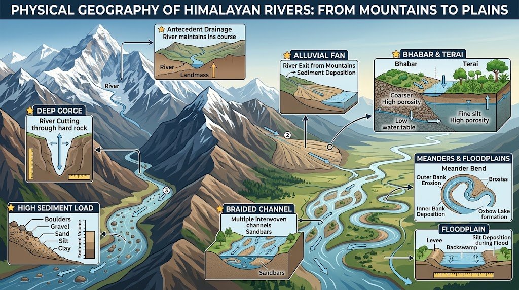
A strong Himalayan Rivers UPSC Prelims 2027 strategy must also cover the physical geography behind river behaviour, including antecedent drainage, gorges, sedimentation, meanders and floodplains.
- Consider the following statements regarding Himalayan rivers:
- Most major Himalayan rivers are perennial.
- Their discharge can receive water from snow and glacier melt.
- Their lower courses are completely unaffected by monsoon rainfall.
Which of the statements given above is/are correct?
(a) 1 and 2 only
(b) 2 only
(c) 1 and 3 only
(d) 1, 2 and 3
- Which one of the following best describes an antecedent river?
(a) A river that developed only after the present mountain relief was formed
(b) A river that maintained its course while uplift of the surrounding terrain took place
(c) A river that disappears into limestone terrain
(d) A river that flows only during the monsoon
- Consider the following statements:
- Deep gorges cut across the Himalayas can be evidence of antecedent drainage.
- Antecedent rivers may be older than the major phases of mountain uplift.
- All Himalayan rivers are antecedent.
Which of the statements given above is/are correct?
(a) 1 and 2 only
(b) 2 only
(c) 1 and 3 only
(d) 1, 2 and 3
- Which one of the following is most likely to occur where a river emerges from a narrow Himalayan valley onto a gentler piedmont slope and rapidly loses carrying capacity?
(a) Formation of an alluvial fan
(b) Formation of a coral reef
(c) Formation of a volcanic cone
(d) Formation of a fjord
- Consider the following statements regarding the Bhabar region:
- It lies along the foothills of the Himalayas.
- Coarse sediments allow streams to disappear temporarily underground.
- It is generally wetter and swampier than the Terai.
Which of the statements given above is/are correct?
(a) 1 and 2 only
(b) 2 only
(c) 1 and 3 only
(d) 1, 2 and 3
- With reference to the Terai region, consider the following statements:
- It lies south of the Bhabar.
- Streams that disappear in the Bhabar may re-emerge in the Terai.
- The region is generally characterised by finer sediments and greater moisture availability.
Which of the statements given above is/are correct?
(a) 1 and 2 only
(b) 1 and 3 only
(c) 2 and 3 only
(d) 1, 2 and 3
- Consider the following statements:
- Himalayan rivers generally carry high sediment loads.
- Their sediment load contributes to the formation of extensive alluvial plains.
- High sediment load always prevents the formation of braided channels.
Which of the statements given above is/are correct?
(a) 1 and 2 only
(b) 2 and 3 only
(c) 1 only
(d) 1, 2 and 3
- Which one of the following is most likely to be associated with repeated lateral shifting of a river channel in a wide alluvial plain?
(a) Meandering and point-bar deposition
(b) Glacial horn formation
(c) Volcanic lava deposition
(d) Marine coral formation
- Consider the following statements about meanders:
- They commonly develop where river gradient is relatively gentle.
- Lateral erosion and deposition help maintain their sinuous form.
- In suitable conditions, a meander loop may become an oxbow lake.
Which of the statements given above is/are correct?
(a) 1 only
(b) 1 and 2 only
(c) 2 and 3 only
(d) 1, 2 and 3
- Which one of the following river processes is most directly associated with the development of an oxbow lake?
(a) Lateral migration and eventual cutoff of a meander loop
(b) Glacial plucking
(c) Vertical erosion in a mountain gorge
(d) Deposition of marine sediments
- Consider the following statements:
- Khadar refers broadly to newer alluvium deposited in the active floodplain.
- Bhangar refers broadly to older alluvial surfaces.
- Khadar is generally found at a lower elevation than the older Bhangar surface.
Which of the statements given above is/are correct?
(a) 1 and 2 only
(b) 1 and 3 only
(c) 2 and 3 only
(d) 1, 2 and 3
- Consider the following statements:
- Himalayan rivers can create extensive floodplains.
- Their floodplains may experience lateral channel migration.
- Floodplain development is unrelated to sediment supply.
Which of the statements given above is/are correct?
(a) 1 and 2 only
(b) 2 only
(c) 1 and 3 only
(d) 1, 2 and 3
- Which one of the following combinations is most characteristic of a mature alluvial river in the plains?
(a) Meanders, floodplains and point bars
(b) Hanging valleys, cirques and arêtes
(c) Lava plateaus and volcanic cones
(d) Deep sea trenches and submarine fans
- Consider the following statements about Himalayan river rejuvenation:
- A fall in base level can increase the river’s erosive capacity.
- Tectonic uplift can encourage renewed vertical erosion.
- Rejuvenation is limited only to rivers originating outside India.
Which of the statements given above is/are correct?
(a) 1 and 2 only
(b) 2 only
(c) 1 and 3 only
(d) 1, 2 and 3
- Which one of the following is a likely consequence of very high sediment deposition in a river channel?
(a) Raising of the river bed and increased flood vulnerability
(b) Permanent elimination of flooding
(c) Complete disappearance of meanders
(d) Conversion of the river into a glacier
- Consider the following statements:
- Braided rivers commonly develop where sediment supply is high and discharge varies considerably.
- Multiple shifting channels are characteristic of braided systems.
- Braided rivers are necessarily confined to steep mountain gorges.
Which of the statements given above is/are correct?
(a) 1 only
(b) 1 and 2 only
(c) 2 and 3 only
(d) 1, 2 and 3
- Which one of the following best explains why Himalayan rivers are particularly important in shaping the Northern Plains?
(a) They carry sediment from the mountains and deposit it across extensive plains.
(b) They transport almost no sediment from the mountains.
(c) They remain confined to narrow gorges throughout their entire courses.
(d) They depend exclusively on underground drainage.
- Consider the following statements:
- River terraces may form when a river incises into an earlier floodplain.
- Tectonic uplift can contribute to river incision.
- Terrace formation is possible only in Peninsular India.
Which of the statements given above is/are correct?
(a) 1 and 2 only
(b) 1 only
(c) 2 and 3 only
(d) 1, 2 and 3
- Which one of the following is most appropriate regarding the relationship between mountain building and Himalayan drainage?
(a) River courses and mountain relief have always been completely independent of each other.
(b) Some major rivers maintained their courses during uplift, producing deep transverse gorges.
(c) All Himalayan rivers originated after the final formation of the present mountains.
(d) Mountain uplift completely blocked all pre-existing drainage.
- Consider the following statements:
- Floods can be natural components of Himalayan river systems.
- Embankments may reduce flooding locally but can also alter sediment movement and channel behaviour.
- Flood management therefore requires only increasing embankment height.
Which of the statements given above is/are correct?
(a) 1 and 2 only
(b) 2 only
(c) 1 and 3 only
(d) 1, 2 and 3
Answers & Explanations: Section 4 of Himalayan Rivers UPSC Prelims 2027: 100 High-Quality MCQs
- (a) — Himalayan rivers are generally perennial and receive water from snow/glacier melt and rainfall. Monsoon rainfall is also important.
- (b) — An antecedent river maintains its course despite uplift of surrounding terrain.
- (a) — Deep transverse gorges can reflect antecedent drainage, and antecedent rivers can predate major phases of uplift. Not all Himalayan rivers are necessarily antecedent.
- (a) — Rapid decrease in slope and carrying capacity promotes deposition, often forming alluvial fans.
- (a) — Bhabar is a coarse, porous piedmont belt where streams can disappear underground. Terai is generally wetter.
- (d) — All three describe the Terai.
- (a) — Himalayan rivers transport large sediment loads and build alluvial plains. High sediment load can actually promote braiding rather than prevent it.
- (a) — Meandering and point-bar deposition are closely associated with lateral channel migration in alluvial plains.
- (d) — All three are standard characteristics of meandering rivers.
- (a) — An oxbow lake forms when a meander loop is cut off from the main river channel.
- (d) — Khadar is younger active floodplain alluvium, while Bhangar is older alluvium at relatively higher surfaces.
- (a) — Floodplains and channel migration are major features of many Himalayan rivers. Sediment supply is highly relevant to floodplain development.
- (a) — Meanders, point bars and floodplains are characteristic features of mature alluvial rivers.
- (a) — Lower base level and tectonic uplift can rejuvenate erosion. Rejuvenation is not geographically restricted in the way statement 3 suggests.
- (a) — Sediment deposition can raise bed levels and contribute to flood risk.
- (b) — High sediment load and changing discharge encourage braiding. Braided rivers are not restricted to steep mountain gorges.
- (a) — Himalayan rivers transport huge quantities of sediment from mountain regions and deposit them over the plains.
- (a) — River terraces can result from incision caused by changes in base level or tectonic uplift.
- (b) — Some Himalayan rivers maintained pre-existing courses during uplift, creating deep transverse gorges.
- (a) — Floods are natural, and embankments can have both benefits and unintended impacts. Flood management cannot be reduced simply to raising embankments.
Section 5: Integrated UPSC-Level Himalayan River Questions
The integrated questions in this Himalayan Rivers UPSC Prelims 2027 section are designed to test connections between river systems, spatial geography and geomorphological processes.
- Consider the following rivers:
- Jhelum
- Ghaghara
- Teesta
- Subansiri
Which of the above are associated with transboundary Himalayan river systems?
(a) 1 and 2 only
(b) 1, 2 and 3 only
(c) 2, 3 and 4 only
(d) 1, 2, 3 and 4
- Consider the following statements:
- The Indus basin extends across India and Pakistan.
- The Ganga basin extends across India and Bangladesh.
- The Brahmaputra basin extends across China, India and Bangladesh.
Which of the statements given above is/are correct?
(a) 1 and 2 only
(b) 2 and 3 only
(c) 1 and 3 only
(d) 1, 2 and 3
- Which one of the following rivers–source-region combinations is correctly matched?
(a) Indus — Tibetan Plateau
(b) Yamuna — Kashmir Valley
(c) Jhelum — Yamunotri
(d) Brahmaputra — Amarkantak
- Consider the following statements:
- The Indus and Brahmaputra both have important portions of their courses north of the Himalayas.
- Both rivers cut across major mountain barriers before reaching the plains.
- The Ganga originates on the Tibetan Plateau.
Which of the statements given above is/are correct?
(a) 1 and 2 only
(b) 2 and 3 only
(c) 1 only
(d) 1, 2 and 3
- With reference to the major Himalayan river systems, consider the following pairs:
- Indus — Arabian Sea
- Ganga — Bay of Bengal
- Brahmaputra — Bay of Bengal
How many of the above pairs are correctly matched?
(a) Only one
(b) Only two
(c) All three
(d) None
- Consider the following statements:
- The Indus is an example of a major river with an antecedent character.
- The Brahmaputra also cuts through the Himalayas in a manner associated with antecedent drainage.
- All tributaries of the Ganga are antecedent rivers.
Which of the statements given above is/are correct?
(a) 1 and 2 only
(b) 1 only
(c) 2 and 3 only
(d) 1, 2 and 3
- Which one of the following sequences correctly arranges the following rivers from west to east according to their major drainage systems?
(a) Indus — Ganga — Brahmaputra
(b) Brahmaputra — Ganga — Indus
(c) Ganga — Indus — Brahmaputra
(d) Brahmaputra — Indus — Ganga
- Consider the following statements:
- The Himalayas act as an important source region for several perennial river systems.
- The Northern Plains owe much of their alluvial character to sediment transported by Himalayan rivers.
- Himalayan rivers are insignificant in the formation of floodplains.
Which of the statements given above is/are correct?
(a) 1 and 2 only
(b) 2 only
(c) 1 and 3 only
(d) 1, 2 and 3
- Which one of the following combinations contains only left-bank tributaries of the Ganga?
(a) Gomati, Ghaghara, Gandak, Kosi
(b) Yamuna, Son, Chambal, Betwa
(c) Son, Gomati, Ghaghara, Kosi
(d) Yamuna, Gandak, Ken, Kosi
- Consider the following statements:
- The Son joins the Ganga from the south.
- The major Himalayan tributaries such as Gomati, Ghaghara, Gandak and Kosi enter the Ganga from the north.
- The Ganga therefore receives tributaries from both the Himalayas and the Peninsular uplands.
Which of the statements given above is/are correct?
(a) 1 and 2 only
(b) 2 and 3 only
(c) 1 and 3 only
(d) 1, 2 and 3
- Consider the following pairs:
River — Basin/Region
- Jhelum — Kashmir Valley
- Yamuna — Uttarakhand and northern plains
- Brahmaputra — Assam Valley
- Sutlej — Punjab and Himachal Pradesh
How many of the above pairs are correctly matched?
(a) Only two
(b) Only three
(c) All four
(d) Only one
- Which one of the following statements is correct regarding Himalayan and Peninsular rivers?
(a) Himalayan rivers are generally younger than all Peninsular rivers in terms of geological setting.
(b) Himalayan rivers often have perennial flow and greater sediment loads, whereas many Peninsular rivers have more established courses over resistant terrain.
(c) All Peninsular rivers are seasonal and all Himalayan rivers are perennial without exception.
(d) Himalayan rivers generally have no meanders.
- Consider the following statements:
- The Ganga and Brahmaputra together contribute to one of the world’s largest deltaic systems.
- The delta is built substantially through deposition of sediments.
- The delta is formed only by marine deposition and not by rivers.
Which of the statements given above is/are correct?
(a) 1 and 2 only
(b) 2 only
(c) 1 and 3 only
(d) 1, 2 and 3
- With reference to Himalayan river floods, consider the following statements:
- Heavy monsoon rainfall can raise discharge sharply.
- Landslides can temporarily obstruct channels and later produce sudden downstream flooding when released.
- Sediment deposition can contribute to aggradation of river beds.
Which of the statements given above is/are correct?
(a) 1 and 2 only
(b) 2 and 3 only
(c) 1 and 3 only
(d) 1, 2 and 3
- Which one of the following is the most appropriate reason for the large number of river terraces found in some Himalayan valleys?
(a) Repeated interaction among uplift, erosion and changes in river base level
(b) Complete absence of tectonic activity
(c) Exclusive marine erosion
(d) Permanent glacier coverage of all valleys
- Consider the following statements:
- The Ganga-Brahmaputra-Meghna system is an important example of an internationally shared river system.
- Water management in such basins may require cooperation among riparian countries.
- Hydrological data sharing can be irrelevant to flood forecasting in transboundary basins.
Which of the statements given above is/are correct?
(a) 1 and 2 only
(b) 2 only
(c) 1 and 3 only
(d) 1, 2 and 3
- Which one of the following rivers is correctly identified on the basis of the following clues?
- It originates in the Tibetan region.
- It enters India through a high mountain pass/valley in Himachal Pradesh.
- It is one of the major tributaries of the Indus.
(a) Sutlej
(b) Gomati
(c) Kosi
(d) Yamuna
- Consider the following statements:
- The Brahmaputra and Teesta systems are geographically associated with the Eastern Himalayas.
- The Jhelum and Chenab systems are associated with the Western Himalayas.
- The Kosi and Gandak are associated with the central/eastern Himalayan drainage reaching the Ganga.
Which of the statements given above is/are correct?
(a) 1 and 2 only
(b) 2 and 3 only
(c) 1 and 3 only
(d) 1, 2 and 3
- A river is described as follows:
- It originates in the Tibetan Plateau.
- It flows through three countries.
- It is an important irrigation river.
- It is an antecedent river and does not form a major delta in its Indian course.
Which one of the following rivers best fits the description?
(a) Yamuna
(b) Sutlej
(c) Gomati
(d) Teesta
- Consider the following statements regarding Himalayan rivers:
- Their importance extends beyond irrigation to hydropower, navigation, ecosystems and groundwater recharge.
- Their high sediment load can simultaneously support soil fertility and increase challenges related to siltation and flooding.
- Sustainable management requires attention to both upstream mountain processes and downstream floodplains.
Which of the statements given above is/are correct?
(a) 1 and 2 only
(b) 2 and 3 only
(c) 1 and 3 only
(d) 1, 2 and 3
Answers & Explanations: Section 5 of Himalayan Rivers UPSC Prelims 2027: 100 High-Quality MCQs
- (d) — All four are associated with international river systems: Jhelum with India-Pakistan, Ghaghara with India-Nepal, Teesta with India-Bangladesh and Subansiri with the wider Brahmaputra basin involving China and India.
- (d) — All three statements are correct.
- (a) — The Indus rises in the Tibetan Plateau. The other source-region pairings are incorrect.
- (a) — Indus and Brahmaputra have significant northern/plateau courses and cut through the mountain system. Ganga originates on the southern side of the Himalayas.
- (c) — All three pairings are correct.
- (a) — Indus and Brahmaputra are prominent examples associated with antecedent drainage. It would be incorrect to classify all Ganga tributaries as antecedent.
- (a) — The broad west-to-east sequence of the three major systems is Indus, Ganga and Brahmaputra.
- (a) — Himalayan rivers are major sources of perennial water and alluvial sediment, and they play a major role in floodplain formation.
- (a) — Gomati, Ghaghara, Gandak and Kosi are major left-bank Himalayan tributaries of the Ganga.
- (d) — All three are correct. Son is a south-bank/right-bank tributary, while the major Himalayan tributaries listed enter from the north.
- (c) — All four river-region associations are correct.
- (b) — This is the most accurate broad comparison. The absolute statements in the other options are incorrect.
- (a) — The Ganga and Brahmaputra contribute to the vast delta, and river-borne sediment is fundamental to its construction.
- (d) — All three processes can contribute to flood risk and river dynamics.
- (a) — Himalayan terraces are linked to tectonic uplift, river incision and changes in erosion/base level conditions.
- (a) — Transboundary rivers require cooperation, and hydrological data can be critical for flood forecasting and water management.
- (a) — Sutlej rises in the Tibetan region, enters Himachal Pradesh through the Shipki La region and is a major Indus tributary.
- (d) — All three regional associations are broadly correct.
- (b) — Sutlej fits the clues: Tibetan origin, transboundary course, irrigation significance and antecedent characteristics.
- (d) — All three statements correctly describe the multidimensional importance and management challenges of Himalayan rivers.
Quick Revision: 20 Himalayan River Facts UPSC Aspirants Should Not Confuse
| River / System | Key Fact |
|---|---|
| Indus | Major transboundary river; drains into Arabian Sea |
| Jhelum | Verinag; associated with Wular |
| Chenab | Chandra + Bhaga |
| Ravi | Western Indus tributary |
| Beas | Joins Sutlej at Harike |
| Sutlej | Tibetan origin; enters India through Shipki La region |
| Ganga | Bhagirathi + Alaknanda at Devprayag |
| Bhagirathi | Gangotri Glacier region |
| Yamuna | Yamunotri region; joins Ganga at Prayagraj |
| Gomati | Left-bank tributary of Ganga |
| Ghaghara | Major Himalayan tributary of Ganga |
| Gandak | Narayani in Nepal |
| Kosi | Highly sediment-laden and channel-shifting |
| Son | Right-bank tributary of Ganga |
| Brahmaputra | Yarlung Tsangpo in Tibet |
| Siang/Dihang | Name associated with Brahmaputra in Arunachal Pradesh |
| Dibang | Brahmaputra system |
| Lohit | Brahmaputra system |
| Teesta | Sikkim–West Bengal–Bangladesh; joins Brahmaputra system |
| Rangeet | Important tributary of Teesta |
How to Use These 100 MCQs for UPSC Prelims 2027
Do not simply memorise the answers.
The actual UPSC pattern shows that a candidate needs to understand relationships between rivers, tributaries, sources, lakes, geographical regions and drainage characteristics. The 2017 Teesta question, 2023 river–lake question, 2024 west-to-east sequencing question and the recent multi-clue river identification pattern illustrate this approach particularly well.
For revision, divide the topic into five mental maps:
Map 1: Indus → Jhelum → Chenab → Ravi → Beas → Sutlej
Map 2: Ganga → Yamuna + Gomati + Ghaghara + Gandak + Kosi + Son
Map 3: Brahmaputra → Siang/Dihang + Dibang + Lohit + Subansiri + Manas
Map 4: Teesta → Rangeet → Brahmaputra system
Map 5: Himalayan processes → antecedence + gorges + sediment + floodplains + meanders + oxbow lakes + Bhabar + Terai
The most important lesson is:
For Himalayan Rivers, UPSC does not test only “Where does the river originate?” It tests how the river behaves, where it flows, which river it joins, which region it crosses, and how it interacts with the surrounding landscape.
The official UPSC previous-question-paper archive should remain the primary reference point while you practise this topic, especially the latest available Civil Services Preliminary papers.
Consistent revision of Himalayan Rivers UPSC Prelims 2027 concepts, maps and statement-based questions can significantly improve accuracy in Geography-based Prelims questions.
After completing these questions, read the UPSC Prelims Previous Year Trends to understand how river-related concepts are tested through statements, sequences and geographical relationships.
Most Important Resources for UPSC Prelims 2027
- Current Affairs For UPSC Prelims 2027
- Polity for UPSC Prelims 2027
- Economy for UPSC Prelims 2027
- History for UPSC Prelims 2027
- Science and Technology for UPSC Prelims 2027
- Geography for UPSC Prelims 2027
3 thoughts on “Himalayan Rivers UPSC Prelims 2027: 100 Outstanding MCQs with Answers & Explanations”