Introduction: Physical Geography of India UPSC MCQs 2027
Physical Geography has consistently been one of the most important components of the UPSC Civil Services Preliminary Examination. In recent years, UPSC has shifted from fact-based questions to conceptual, statement-based, and application-oriented questions. Aspirants are expected to understand geographical processes rather than merely memorize facts.
This series of 100 carefully designed MCQs follows the latest UPSC trend observed over the past decade. The questions emphasize reasoning, conceptual clarity, and analytical thinking while covering major themes of India’s physical geography.
These Physical Geography of India UPSC MCQs are specially designed for UPSC CSE Prelims 2027 aspirants. The questions follow the latest UPSC pattern and cover physiography, rivers, climate, soils, natural vegetation, biosphere reserves, and map-based concepts.
UPSC Trend Analysis: Physical Geography
Analysis of recent UPSC Prelims papers shows that Physical Geography questions commonly focus on:
- Himalayan geomorphology
- Peninsular Plateau
- River systems
- Drainage patterns
- Monsoon dynamics
- Mountain passes
- Coastal landforms
- Islands
- Soil formation
- Climate and atmospheric circulation
Instead of direct factual recall, UPSC increasingly asks candidates to evaluate multiple statements and identify the correct combination.
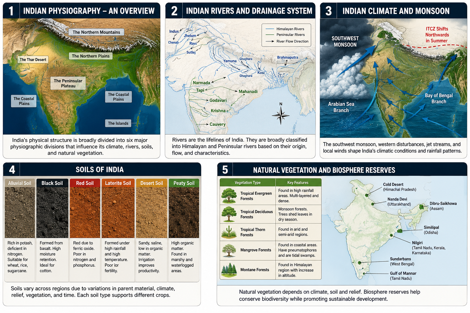
Section 1: Physiographic Divisions of India (Questions 1–20 of Physical Geography of India UPSC MCQs 2027)
Start solving these Physical Geography of India MCQs section-wise. Each question tests conceptual understanding rather than factual memorization, similar to recent UPSC Prelims papers.
Check your performance after attempting all Physical Geography of India MCQs without referring to the answers. This approach helps improve elimination techniques and conceptual clarity.
Q1.
With reference to the Himalayas, consider the following statements:
- The Greater Himalayas contain the highest mountain peaks of India.
- Most major Himalayan glaciers originate in the Greater Himalayas.
- The Greater Himalayas are composed mainly of recent alluvial deposits.
Which of the statements given above is/are correct?
A. 1 and 2 only
B. 2 and 3 only
C. 1 only
D. 1, 2 and 3
Q2.
Consider the following statements regarding the Northern Plains:
- They were formed primarily by the deposition of sediments brought by Himalayan rivers.
- Bhangar represents older alluvium.
- Khadar is generally renewed during floods.
Select the correct answer using the code below.
A. 1 only
B. 1 and 2 only
C. 2 and 3 only
D. 1, 2 and 3
Q3.
Which one of the following best explains the occurrence of deep river valleys in the Himalayan region?
A. High rate of chemical weathering
B. Intense tectonic uplift combined with river erosion
C. Wind erosion
D. Coastal submergence
Q4.
Consider the following statements regarding the Peninsular Plateau:
- It is geologically more stable than the Himalayan region.
- Most rivers flowing through it are antecedent rivers.
- It consists mainly of ancient crystalline rocks.
Which of the above statements is/are correct?
A. 1 and 3 only
B. 2 only
C. 1 and 2 only
D. 1, 2 and 3
Q5.
Which one of the following physiographic divisions is associated with the Deccan Trap formation?
A. Western Coastal Plain
B. Deccan Plateau
C. Northern Plains
D. Shiwalik Range
Q6.
Consider the following statements:
- The Western Ghats act as a climatic barrier.
- They are generally higher than the Eastern Ghats.
- They form a nearly continuous mountain chain.
Which of the statements given above are correct?
A. 1 only
B. 1 and 2 only
C. 2 and 3 only
D. 1, 2 and 3
Q7.
The Meghalaya Plateau is separated from the Peninsular Plateau by
A. Chambal Valley
B. Garo Gap
C. Malda Gap
D. Rajmahal Gap
Q8.
Consider the following statements:
- The Eastern Ghats are highly dissected by rivers.
- The Western Ghats are crossed by very few river valleys.
- The Eastern Ghats are continuous throughout their length.
Which statements are correct?
A. 1 and 2 only
B. 2 and 3 only
C. 1 only
D. 1, 2 and 3
Q9.
The formation of Bhabar and Terai is primarily associated with
A. Marine deposition
B. Himalayan river deposition
C. Wind action
D. Volcanic activity
Q10.
Which of the following best explains the existence of numerous waterfalls along rivers descending the Western Ghats?
A. River rejuvenation
B. Faulted escarpment and steep gradient
C. Marine erosion
D. Aeolian processes
Q11.
Consider the following statements:
- The Aravalli Range is among the oldest fold mountains in India.
- It extends in a northeast-southwest direction.
- It acts as an effective barrier to the southwest monsoon.
Which statements are correct?
A. 1 and 2 only
B. 2 and 3 only
C. 1 only
D. 1, 2 and 3
Q12.
The highest plateau in India is
A. Malwa Plateau
B. Chota Nagpur Plateau
C. Ladakh Plateau
D. Karnataka Plateau
Q13.
Consider the following statements:
- The Indo-Gangetic Plain has a very gentle slope towards the east.
- Meanders are common in the middle and lower courses of rivers.
- Natural levees are absent from the floodplains.
Select the correct answer.
A. 1 and 2 only
B. 2 only
C. 1 only
D. 1, 2 and 3
Q14.
The Deccan Plateau is drained mainly by rivers flowing
A. Northward
B. Westward
C. Eastward
D. Southward
Q15.
Which of the following regions is most prone to landslides due to active tectonics and steep slopes?
A. Indo-Gangetic Plain
B. Western Rajasthan
C. Himalayas
D. Deccan Plateau
Q16.
Consider the following statements:
- The Shiwalik Hills are composed largely of unconsolidated sediments.
- They are the youngest Himalayan ranges.
- They experience frequent landslides.
Which statements are correct?
A. 1 only
B. 2 and 3 only
C. 1 and 2 only
D. 1, 2 and 3
Q17.
The discontinuity in the Western Ghats through which transport links between Kerala and Tamil Nadu pass is
A. Palghat Gap
B. Malda Gap
C. Palk Strait
D. Bhor Ghat
Q18.
Which one of the following statements regarding the Eastern Coastal Plain is correct?
A. It is narrower than the Western Coastal Plain.
B. It contains large river deltas.
C. It is mainly rocky.
D. It has numerous estuaries.
Q19.
Consider the following statements:
- The Peninsular rivers generally have fixed courses.
- They depend largely on rainfall.
- They carry large volumes of water throughout the year.
Which statements are correct?
A. 1 and 2 only
B. 2 and 3 only
C. 1 only
D. 1, 2 and 3
Q20.
Which one of the following physiographic divisions contains the largest continuous alluvial plain in India?
A. Peninsular Plateau
B. Northern Plains
C. Coastal Plains
D. Indian Desert
Answers with Short Explanations for Section 1 of Physical Geography of India UPSC MCQs 2027
| Q | Ans | Explanation |
|---|---|---|
| 1 | A | The Greater Himalayas contain the highest peaks and major glaciers. They are composed mainly of crystalline and metamorphic rocks, not recent alluvium. |
| 2 | D | The Northern Plains were formed by alluvial deposition. Bhangar is older alluvium, while Khadar is renewed annually during floods. |
| 3 | B | Rapid tectonic uplift combined with strong river erosion creates deep gorges and valleys in the Himalayas. |
| 4 | A | The Peninsular Plateau is geologically stable and consists largely of ancient crystalline rocks. Antecedent rivers are mainly associated with the Himalayas. |
| 5 | B | The Deccan Plateau is famous for the extensive basaltic Deccan Trap lava flows. |
| 6 | D | The Western Ghats are higher, continuous, and intercept southwest monsoon winds, causing orographic rainfall. |
| 7 | D | The Meghalaya Plateau is separated from the Peninsular Plateau by the Rajmahal Gap. |
| 8 | A | The Eastern Ghats are dissected by rivers and discontinuous; therefore Statement 3 is incorrect. |
| 9 | B | Bhabar and Terai are depositional features formed by Himalayan rivers at the foothills. |
| 10 | B | The steep western escarpment of the Western Ghats creates numerous waterfalls. |
| 11 | A | The Aravallis are among the oldest fold mountains and trend northeast–southwest. They are not high enough to block the southwest monsoon effectively. |
| 12 | C | The Ladakh Plateau is the highest plateau in India, lying in the Trans-Himalayan region. |
| 13 | A | Natural levees are common on floodplains; therefore Statement 3 is incorrect. |
| 14 | C | Most major Peninsular rivers, such as the Godavari, Krishna, and Kaveri, flow eastward into the Bay of Bengal. |
| 15 | C | Young fold mountains, steep gradients, and active tectonics make the Himalayas highly prone to landslides. |
| 16 | D | The Shiwaliks are the youngest Himalayan ranges, composed of loose sediments and highly susceptible to landslides. |
| 17 | A | The Palghat Gap is a major low pass connecting Kerala and Tamil Nadu. |
| 18 | B | The Eastern Coastal Plain is broad and characterized by extensive river deltas. |
| 19 | A | Peninsular rivers generally have fixed courses and are largely rain-fed, so they are not perennial with large year-round discharge. |
| 20 | B | The Northern Plains form India’s largest continuous alluvial plain. |
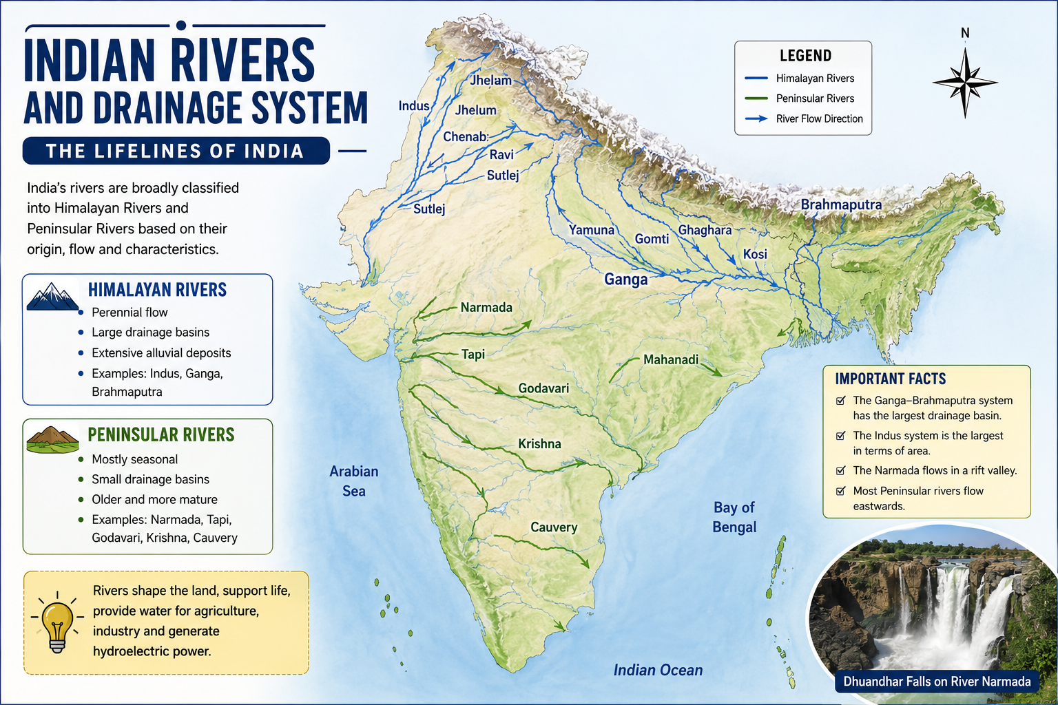
Section 2: Himalayan Rivers & Peninsular Rivers (Questions 21–40 of Physical Geography of India UPSC MCQs 2027)
Start solving these Physical Geography of India UPSC MCQs section-wise. Each question tests conceptual understanding rather than factual memorization, similar to recent UPSC Prelims papers.
Q21.
Consider the following statements regarding the Indus River system:
- The Indus originates near Lake Manasarovar in Tibet.
- The Sutlej is the longest tributary of the Indus.
- The Beas originates from the Rohtang Pass region.
Which of the statements given above are correct?
A. 1 and 2 only
B. 1 and 3 only
C. 2 and 3 only
D. 1, 2 and 3
Q22.
Consider the following statements:
- The Brahmaputra enters India through Arunachal Pradesh.
- It is known as the Siang before entering Assam.
- It carries a larger volume of water than the Ganga.
Select the correct answer.
A. 1 only
B. 1 and 2 only
C. 1 and 3 only
D. 1, 2 and 3
Q23.
With reference to the Ganga River, consider the following statements:
- The Bhagirathi originates from the Gangotri Glacier.
- The Alaknanda joins the Bhagirathi at Devprayag.
- The Ganga enters the plains at Haridwar.
Which of the above statements is/are correct?
A. 1 and 2 only
B. 2 and 3 only
C. 1 and 3 only
D. 1, 2 and 3
Q24.
Which one of the following rivers forms the famous Hundru Falls?
A. Damodar
B. Subarnarekha
C. Mahanadi
D. Chambal
Q25.
Consider the following statements:
- Most Himalayan rivers are perennial.
- Peninsular rivers depend mainly on rainfall.
- Himalayan rivers generally have wider floodplains than Peninsular rivers.
Select the correct answer.
A. 1 only
B. 1 and 2 only
C. 2 and 3 only
D. 1, 2 and 3
Q26.
Which one of the following rivers flows through a rift valley?
A. Krishna
B. Narmada
C. Godavari
D. Kaveri
Q27.
Consider the following statements regarding the Godavari River:
- It rises near Nashik.
- It drains the largest river basin in Peninsular India.
- It flows into the Arabian Sea.
Which statements are correct?
A. 1 only
B. 1 and 2 only
C. 2 and 3 only
D. 1, 2 and 3
Q28.
Which one of the following pairs is correctly matched?
| River | Tributary |
|---|---|
| A. Yamuna | Chambal |
| B. Krishna | Son |
| C. Godavari | Betwa |
| D. Narmada | Gandak |
Q29.
Consider the following statements:
- Antecedent rivers maintain their original course despite uplift of land.
- The Indus is regarded as an antecedent river.
- Antecedent drainage is commonly associated with the Himalayas.
Which statements are correct?
A. 1 and 2 only
B. 2 and 3 only
C. 1 and 3 only
D. 1, 2 and 3
Q30.
Which of the following rivers forms the largest delta in India?
A. Godavari
B. Krishna
C. Ganga
D. Mahanadi
Q31.
Consider the following statements:
- East-flowing Peninsular rivers generally form deltas.
- West-flowing Peninsular rivers usually form estuaries.
- The Narmada and Tapi are examples of west-flowing rivers.
Select the correct answer.
A. 1 and 2 only
B. 2 and 3 only
C. 1 and 3 only
D. 1, 2 and 3
Q32.
The river known as the “Dakshin Ganga” is
A. Krishna
B. Kaveri
C. Godavari
D. Mahanadi
Q33.
Consider the following statements:
- River capture may alter the drainage pattern.
- River capture occurs due to headward erosion.
- River capture is impossible in mountainous regions.
Which statements are correct?
A. 1 only
B. 1 and 2 only
C. 2 and 3 only
D. 1, 2 and 3
Q34.
Which one of the following rivers does not originate in the Western Ghats?
A. Krishna
B. Godavari
C. Tapi
D. Chambal
Q35.
Consider the following statements:
- The Chambal River is known for badland topography.
- It is a tributary of the Yamuna.
- It originates in the Vindhya Range.
Which statements are correct?
A. 1 and 2 only
B. 2 and 3 only
C. 1 and 3 only
D. 1, 2 and 3
Q36.
The largest tributary of the Ganga by discharge is
A. Yamuna
B. Ghaghara
C. Son
D. Gomti
Q37.
Consider the following statements:
- Drainage density is generally higher in regions of impermeable rocks.
- Areas receiving heavy rainfall tend to have higher drainage density.
- Highly permeable rocks usually have low drainage density.
Which statements are correct?
A. 1 and 2 only
B. 2 and 3 only
C. 1 and 3 only
D. 1, 2 and 3
Q38.
Which one of the following drainage patterns is commonly associated with folded mountain regions?
A. Dendritic
B. Radial
C. Trellis
D. Annular
Q39.
Consider the following statements:
- The Kaveri River originates in the Brahmagiri Hills.
- It forms the Shivanasamudra Falls.
- It empties into the Arabian Sea.
Which statements are correct?
A. 1 only
B. 1 and 2 only
C. 2 and 3 only
D. 1, 2 and 3
Q40.
Which one of the following rivers flows through the Marble Rocks near Jabalpur?
A. Tapi
B. Narmada
C. Son
D. Mahanadi
Answers with Short Explanations for Section 2 of Physical Geography of India UPSC MCQs 2027
| Q | Answer | Short Explanation |
|---|---|---|
| 21 | D | The Indus originates near Lake Manasarovar. Sutlej is its longest tributary, and the Beas rises near Rohtang Pass. |
| 22 | D | The Brahmaputra enters India through Arunachal Pradesh as the Siang (also called Dihang) and carries enormous discharge, exceeding that of the Ganga. |
| 23 | D | Bhagirathi originates from Gangotri Glacier, joins Alaknanda at Devprayag, and the Ganga enters the plains at Haridwar. |
| 24 | B | Hundru Falls is formed by the Subarnarekha River in Jharkhand. |
| 25 | D | Himalayan rivers are perennial and form broad floodplains, whereas Peninsular rivers are mainly rain-fed. |
| 26 | B | The Narmada flows westward through a tectonic rift valley. |
| 27 | B | The Godavari rises near Nashik, has the largest Peninsular basin, and drains into the Bay of Bengal. |
| 28 | A | The Chambal is an important tributary of the Yamuna. The remaining pairs are incorrect. |
| 29 | D | Antecedent rivers retain their course despite uplift; the Indus is a classic example. |
| 30 | C | The Ganga-Brahmaputra system forms the world’s largest delta. |
| 31 | D | East-flowing rivers generally form deltas, while west-flowing rivers like Narmada and Tapi form estuaries. |
| 32 | C | The Godavari is popularly known as the “Dakshin Ganga.” |
| 33 | B | River capture occurs due to headward erosion and is common in mountainous terrain. |
| 34 | D | The Chambal originates in the Vindhya region, not the Western Ghats. |
| 35 | D | The Chambal originates in the Vindhyas, joins the Yamuna, and is famous for ravines and badlands. |
| 36 | B | The Ghaghara contributes the largest discharge among the Ganga’s tributaries. |
| 37 | D | Impermeable rocks and high rainfall increase drainage density, while permeable rocks reduce it. |
| 38 | C | Trellis drainage typically develops in folded mountain regions with alternating hard and soft rock strata. |
| 39 | B | The Kaveri originates in the Brahmagiri Hills, forms Shivanasamudra Falls, and flows into the Bay of Bengal. |
| 40 | B | The Marble Rocks and Dhuandhar Falls near Jabalpur are formed by the Narmada River. |
Section 2 Score Card
- 17–20: Excellent UPSC-level command over Indian River Systems.
- 13–16: Good preparation; revise drainage patterns and tributaries.
- 9–12: Moderate understanding; strengthen concepts using maps.
- Below 9: Revisit NCERT Class XI Geography and river basin maps before attempting advanced MCQs.
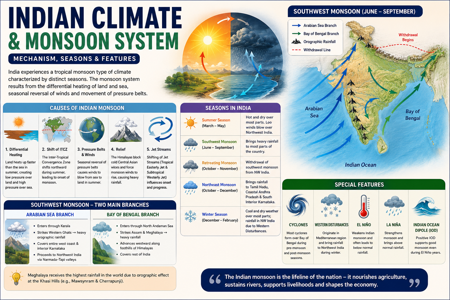
Section 3: Indian Climate, Monsoon, Winds, Rainfall & Climatic Regions (Questions 41–60 of Physical Geography of India UPSC MCQs 2027)
These Physical Geography of India UPSC MCQs on Indian Climate include monsoon, jet streams, local winds, rainfall distribution, Western Disturbances, El Niño, La Niña, and climate-related concepts.
Q41.
Consider the following statements regarding the Indian Summer Monsoon:
- Differential heating of land and sea is one of the primary causes of the southwest monsoon.
- The seasonal northward shift of the Inter-Tropical Convergence Zone (ITCZ) facilitates the onset of the southwest monsoon.
- The Coriolis force is solely responsible for the origin of the Indian monsoon.
Which of the statements given above is/are correct?
A. 1 and 2 only
B. 2 only
C. 1 and 3 only
D. 1, 2 and 3
Q42.
Consider the following statements:
- The Arabian Sea branch of the southwest monsoon reaches Kerala before the Bay of Bengal branch enters northeastern India.
- The Bay of Bengal branch, after striking the Khasi Hills, advances westward along the Himalayan foothills.
- The Arabian Sea branch causes heavy orographic rainfall on the windward side of the Western Ghats.
Which of the statements given above are correct?
A. 1 and 2 only
B. 2 and 3 only
C. 1 and 3 only
D. 1, 2 and 3
Q43.
Mawsynram receives exceptionally high annual rainfall mainly because of
A. frequent tropical cyclones originating over the Bay of Bengal
B. intense convection over the Meghalaya Plateau
C. orographic uplift of moisture-laden monsoon winds against the Khasi Hills
D. repeated western disturbances during summer
Q44.
Consider the following statements regarding Western Disturbances:
- They originate over the Mediterranean region.
- They are associated with temperate cyclones embedded in the Subtropical Westerly Jet.
- They bring winter rainfall to northwestern India and snowfall in the western Himalayas.
Which of the statements given above are correct?
A. 1 only
B. 1 and 2 only
C. 2 and 3 only
D. 1, 2 and 3
Q45.
Which one of the following coastal regions receives a substantial proportion of its annual rainfall during the Northeast Monsoon?
A. Konkan Coast
B. Malabar Coast
C. Coromandel Coast
D. Kathiawar Coast
Q46.
Consider the following statements:
- During winter, a high-pressure area develops over northwestern India.
- The northeast monsoon winds generally blow from land towards the Bay of Bengal.
- Tamil Nadu receives a significant part of its annual rainfall from the northeast monsoon.
Which of the statements given above are correct?
A. 1 and 2 only
B. 2 and 3 only
C. 1 and 3 only
D. 1, 2 and 3
Q47.
The rain-shadow region over the Deccan Plateau is primarily formed due to
A. blocking effect of the Eastern Ghats
B. orographic barrier created by the Western Ghats
C. influence of tropical cyclones
D. northeast monsoon winds
Q48.
Consider the following statements regarding the Retreating Monsoon:
- The withdrawal of the southwest monsoon begins from northwestern India.
- Tropical cyclones frequently develop over the Bay of Bengal during this season.
- The retreating monsoon is generally associated with high humidity and oppressive weather over much of Peninsular India.
Which of the statements given above are correct?
A. 1 only
B. 1 and 2 only
C. 2 and 3 only
D. 1, 2 and 3
Q49.
Which one of the following regions experiences the highest annual range of temperature in India?
A. Konkan Coast
B. Thar Desert
C. Brahmaputra Valley
D. Andaman Islands
Q50.
Consider the following statements:
- El Niño conditions generally weaken the Indian Summer Monsoon.
- La Niña years are often associated with better-than-normal monsoon rainfall over India.
- Every El Niño year necessarily results in drought in India.
Which of the statements given above are correct?
A. 1 and 2 only
B. 1 only
C. 2 and 3 only
D. 1, 2 and 3
Q51.
With reference to Jet Streams, consider the following statements:
- The Subtropical Westerly Jet lies south of the Himalayas during winter.
- The Tropical Easterly Jet develops during the summer monsoon.
- Seasonal shifting of Jet Streams influences the onset of the Indian Monsoon.
Which of the statements given above are correct?
A. 1 and 2 only
B. 2 and 3 only
C. 1 and 3 only
D. 1, 2 and 3
Q52.
Consider the following pairs:
| Local Weather Phenomenon | Region |
|---|---|
| 1. Loo | Northern Plains |
| 2. Kalbaisakhi | Eastern India |
| 3. Mango Showers | Kerala and Karnataka |
How many of the above pairs are correctly matched?
A. Only one
B. Only two
C. All three
D. None
Q53.
Which one of the following places receives the least average annual rainfall?
A. Jaisalmer
B. Pune
C. Patna
D. Shillong
Q54.
Consider the following statements regarding temperature distribution in India:
- Coastal regions generally experience a lower annual range of temperature than interior regions.
- Altitude influences the distribution of temperature.
- Continentality has little influence on the annual temperature range.
Which of the statements given above are correct?
A. 1 and 2 only
B. 1 only
C. 2 and 3 only
D. 1, 2 and 3
Q55.
Chennai receives comparatively less rainfall during the Southwest Monsoon mainly because
A. it is located far away from the sea
B. it lies on the leeward side of the Western Ghats
C. the Bay of Bengal branch bypasses the Tamil Nadu coast
D. convectional rainfall is absent in southern India
Q56.
Consider the following statements:
- Most tropical cyclones affecting India originate over the Bay of Bengal.
- Odisha and Andhra Pradesh are among the most cyclone-prone states.
- Tropical cyclones occur only during the retreating monsoon season.
Which of the statements given above are correct?
A. 1 and 2 only
B. 2 only
C. 2 and 3 only
D. 1, 2 and 3
Q57.
Which one of the following is correctly matched?
A. Mango Showers — Kerala and Karnataka
B. Loo — Assam
C. Kalbaisakhi — Rajasthan
D. Western Disturbances — Tamil Nadu
Q58.
Consider the following statements:
- Rainfall generally decreases from east to west across the Northern Plains.
- The windward slopes of the Western Ghats receive heavy rainfall.
- Ladakh lies in a rain-shadow region.
Which of the statements given above are correct?
A. 1 and 2 only
B. 2 and 3 only
C. 1 and 3 only
D. 1, 2 and 3
Q59.
The ‘Burst of the Monsoon’ over Kerala is primarily associated with
A. arrival of moisture-laden cross-equatorial winds
B. sudden increase in western disturbances
C. formation of local dust storms
D. weakening of the northeast trade winds
Q60.
Consider the following statements:
- India experiences a Tropical Monsoon type of climate.
- The Himalayas prevent the cold continental winds of Central Asia from entering the Indian subcontinent.
- The Himalayas also play an important role in the development and maintenance of the Indian Monsoon.
Which of the statements given above are correct?
A. 1 and 2 only
B. 2 and 3 only
C. 1 and 3 only
D. 1, 2 and 3
After practicing these climate questions, solve our Current Affairs MCQs to connect static geography with recent climate and environment-related developments.
Answers with Short Explanations for Section 3 of Physical Geography of India UPSC MCQs 2027
| Q | Ans | Explanation |
|---|---|---|
| 41 | A | Differential heating and the northward shift of the ITCZ are major causes of the Indian Monsoon. Coriolis force only deflects winds; it is not the sole cause. |
| 42 | D | All three statements are correct. The Arabian Sea branch reaches Kerala first, while the Bay branch strikes the Khasi Hills before moving westward. |
| 43 | C | Mawsynram’s exceptionally high rainfall is due to strong orographic uplift of moisture-laden monsoon winds against the Khasi Hills. |
| 44 | D | Western Disturbances originate over the Mediterranean region, travel with the Subtropical Westerly Jet, and bring winter rain and snowfall to northwestern India. |
| 45 | C | The Coromandel Coast receives most of its rainfall during the Northeast Monsoon (October–December). |
| 46 | D | All three statements are correct. Winter high pressure over northwestern India drives the northeast monsoon, which brings rainfall to Tamil Nadu. |
| 47 | B | The Western Ghats intercept the southwest monsoon, creating a rain-shadow region over the Deccan Plateau. |
| 48 | D | Withdrawal starts from northwestern India. Cyclonic storms are common over the Bay of Bengal, and humid conditions prevail in Peninsular India. |
| 49 | B | The Thar Desert experiences the highest annual temperature range because of continentality and arid conditions. |
| 50 | A | El Niño generally weakens the monsoon, while La Niña often strengthens it. However, not every El Niño year results in drought. |
| 51 | D | All three statements correctly describe the seasonal behavior of the Jet Streams and their influence on the Indian Monsoon. |
| 52 | C | All three pairs are correctly matched. These local weather phenomena are frequently tested in UPSC. |
| 53 | A | Jaisalmer receives less than 200 mm of annual rainfall and is one of the driest places in India. |
| 54 | A | Coastal influence and altitude affect temperature distribution, whereas continentality has a major influence, making Statement 3 incorrect. |
| 55 | B | Chennai lies on the leeward side of the Western Ghats during the southwest monsoon, resulting in comparatively low rainfall. |
| 56 | A | Most Indian cyclones originate over the Bay of Bengal, and Odisha and Andhra Pradesh are highly vulnerable. Cyclones also occur during the pre-monsoon season. |
| 57 | A | Mango Showers are pre-monsoon rains in Kerala and Karnataka that help in the early ripening of mangoes. |
| 58 | D | Rainfall decreases from east to west across the Northern Plains. The Western Ghats receive heavy windward rainfall, while Ladakh lies in a rain-shadow region. |
| 59 | A | The onset or “burst” of the southwest monsoon is marked by the arrival of strong moisture-laden cross-equatorial winds over Kerala. |
| 60 | D | All three statements are correct. India’s climate is tropical monsoon, and the Himalayas play a crucial role in shaping both winter and monsoon climate patterns. |
To understand the latest developments related to the Indian Monsoon and climate patterns, aspirants should regularly consult the India Meteorological Department (IMD).
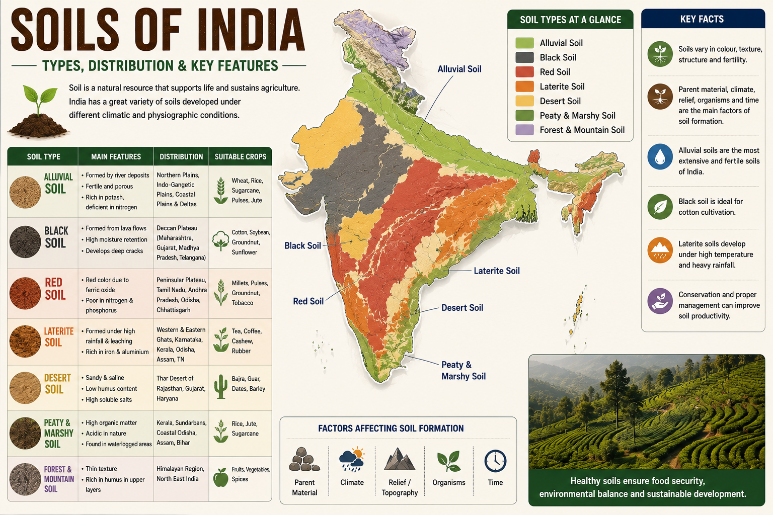
Section 4: Soils, Natural Vegetation & Biosphere Reserves (Questions 61–80 of Physical Geography of India UPSC MCQs 2027)
Continue practicing Physical Geography of India UPSC MCQs covering soils, natural vegetation, biosphere reserves, mangroves, and environmental geography important for UPSC.
Q61.
Consider the following statements regarding Alluvial Soils:
- They are the most extensive soil type in India.
- They are generally rich in potash but deficient in nitrogen.
- They are ideally suited for the cultivation of wheat and sugarcane.
Which of the statements given above are correct?
A. 1 and 2 only
B. 2 and 3 only
C. 1 and 3 only
D. 1, 2 and 3
Q62.
Black Cotton Soil is primarily formed due to the weathering of
A. Granite
B. Basalt
C. Sandstone
D. Limestone
Q63.
Consider the following statements:
- Black soils possess high moisture-retaining capacity.
- They develop wide cracks during the dry season.
- They are particularly suitable for cotton cultivation.
Which of the statements given above are correct?
A. 1 only
B. 2 and 3 only
C. 1 and 3 only
D. 1, 2 and 3
Q64.
Laterite soils are generally formed under conditions of
A. Low temperature and scanty rainfall
B. High temperature and heavy seasonal rainfall
C. Cold desert climate
D. Temperate grassland climate
Q65.
Consider the following statements regarding Red Soils:
- Their red colour is mainly due to ferric oxide.
- They are generally poor in nitrogen and phosphorus.
- They are found extensively in the Deccan Plateau.
Which of the statements given above are correct?
A. 1 and 2 only
B. 2 and 3 only
C. 1 and 3 only
D. 1, 2 and 3
Q66.
Which one of the following soils is best suited for cotton cultivation?
A. Laterite Soil
B. Black Soil
C. Desert Soil
D. Peaty Soil
Q67.
Consider the following statements regarding Desert Soils:
- They generally contain high soluble salts.
- They have low organic matter.
- Irrigation can considerably improve their productivity.
Which of the statements given above are correct?
A. 1 only
B. 1 and 2 only
C. 2 and 3 only
D. 1, 2 and 3
Q68.
Montane forests in India are mainly associated with
A. Coastal Plains
B. Himalayan Region
C. Thar Desert
D. Deccan Plateau
Q69.
Consider the following statements:
- Tropical Evergreen Forests receive rainfall exceeding 200 cm annually.
- Trees in these forests generally shed their leaves simultaneously during summer.
- Ebony and Rosewood are important species found in these forests.
Which of the statements given above are correct?
A. 1 and 2 only
B. 2 and 3 only
C. 1 and 3 only
D. 1, 2 and 3
Q70.
Which one of the following forest types occupies the largest forest area in India?
A. Tropical Evergreen Forests
B. Tropical Thorn Forests
C. Tropical Deciduous Forests
D. Littoral and Swamp Forests
Q71.
Consider the following statements regarding Tropical Deciduous Forests:
- They are also known as Monsoon Forests.
- They shed leaves during the dry season.
- Teak and Sal are the dominant commercial species.
Which of the statements given above are correct?
A. 1 only
B. 1 and 2 only
C. 2 and 3 only
D. 1, 2 and 3
Q72.
Mangrove forests are best adapted to
A. Cold mountainous regions
B. Saline coastal marshes and tidal creeks
C. Dry desert climate
D. High-altitude grasslands
Q73.
Consider the following statements:
- Mangroves possess pneumatophores.
- Sundari is a characteristic tree species of the Sundarbans.
- Mangrove forests protect coastal areas from storm surges.
Which of the statements given above are correct?
A. 1 and 2 only
B. 2 and 3 only
C. 1 and 3 only
D. 1, 2 and 3
Q74.
Which one of the following Biosphere Reserves is located in the Nilgiri Hills?
A. Similipal
B. Nilgiri
C. Pachmarhi
D. Dibru-Saikhowa
Q75.
Consider the following statements regarding Biosphere Reserves:
- They aim to conserve biodiversity.
- They promote sustainable development.
- They generally consist of Core, Buffer and Transition Zones.
Which of the statements given above are correct?
A. 1 only
B. 2 and 3 only
C. 1 and 3 only
D. 1, 2 and 3
Q76.
Which one of the following Biosphere Reserves is famous for the conservation of the Lion-tailed Macaque?
A. Nilgiri
B. Cold Desert
C. Gulf of Mannar
D. Nanda Devi
Q77.
Consider the following statements:
- Soil erosion by water is more severe in areas lacking vegetation.
- Afforestation helps reduce soil erosion.
- Contour ploughing is an effective soil conservation measure in hilly regions.
Which of the statements given above are correct?
A. 1 only
B. 1 and 2 only
C. 2 and 3 only
D. 1, 2 and 3
Q78.
Which one of the following factors contributes most to the formation of Laterite Soil?
A. Intense leaching
B. Glacial deposition
C. Wind erosion
D. Marine sedimentation
Q79.
Consider the following statements regarding Peaty and Marshy Soils:
- They contain high organic matter.
- They are generally acidic in nature.
- They occur in parts of Kerala and the Sundarbans.
Which of the statements given above are correct?
A. 1 and 2 only
B. 2 and 3 only
C. 1 and 3 only
D. 1, 2 and 3
Q80.
Which one of the following statements is correct regarding India’s Natural Vegetation?
A. Distribution depends only on rainfall.
B. Altitude has no influence on vegetation.
C. Climate, soil and relief together influence vegetation distribution.
D. Vegetation remains uniform throughout the country.
Answers with Short Explanations for Section 4 of Physical Geography of India UPSC MCQs 2027
| Q | Ans | Explanation |
|---|---|---|
| 61 | D | Alluvial soils are India’s most extensive soils, rich in potash but deficient in nitrogen, and highly suitable for crops like wheat and sugarcane. |
| 62 | B | Black soils originate from the weathering of basaltic lava of the Deccan Trap region. |
| 63 | D | Black soils retain moisture, develop deep cracks on drying, and are ideal for cotton cultivation. |
| 64 | B | Laterite soils develop under conditions of high temperature, heavy rainfall and intense leaching. |
| 65 | D | Red soils owe their colour to ferric oxide, are nutrient-deficient, and occur widely over the Peninsular Plateau. |
| 66 | B | Black soil is popularly known as Black Cotton Soil because of its suitability for cotton. |
| 67 | D | Desert soils are saline, poor in humus, but become productive with irrigation and proper management. |
| 68 | B | Montane forests occur mainly in the Himalayan and high-altitude regions. |
| 69 | C | Evergreen forests receive heavy rainfall and contain species like ebony and rosewood. They do not shed leaves simultaneously. |
| 70 | C | Tropical Deciduous (Monsoon) Forests occupy the largest forest area in India. |
| 71 | D | These forests are called monsoon forests, shed leaves in the dry season, and are dominated by teak and sal. |
| 72 | B | Mangroves thrive in saline, tidal coastal environments. |
| 73 | D | Mangroves possess breathing roots (pneumatophores), Sundari is the dominant tree of the Sundarbans, and mangroves protect coasts from cyclones and storm surges. |
| 74 | B | The Nilgiri Biosphere Reserve was India’s first Biosphere Reserve. |
| 75 | D | Biosphere Reserves combine conservation with sustainable development through Core, Buffer and Transition Zones. |
| 76 | A | The Nilgiri Biosphere Reserve is an important habitat of the endangered Lion-tailed Macaque. |
| 77 | D | Vegetation cover, afforestation and contour ploughing are all effective methods of soil conservation. |
| 78 | A | Laterite soil develops due to intense leaching under humid tropical conditions. |
| 79 | D | Peaty and Marshy soils are rich in organic matter, acidic, and occur in Kerala, the Sundarbans and other marshy areas. |
| 80 | C | Natural vegetation depends on an interaction of climate, soil, relief and altitude rather than a single factor. |
To improve conceptual clarity, also read our detailed Environment MCQs for UPSC, covering biodiversity, biosphere reserves, forests, and conservation.
Section 5: Integrated Physical Geography of India (Questions 81–100 of Physical Geography of India UPSC MCQs 2027)
The final section of Physical Geography of India UPSC MCQs consists of integrated and map-based questions. These are designed to match the analytical level of recent UPSC CSE Prelims examinations.
Q81.
Consider the following statements regarding the Western Ghats:
- They are older than the Himalayas.
- They form a continuous escarpment along the western margin of the Peninsular Plateau.
- UNESCO has recognized several sites in the Western Ghats as World Heritage Sites.
Which of the statements given above are correct?
A. 1 and 2 only
B. 2 and 3 only
C. 1 and 3 only
D. 1, 2 and 3
Q82.
Which one of the following rivers does not originate in the Western Ghats?
A. Periyar
B. Mahanadi
C. Krishna
D. Godavari
Q83.
Consider the following statements:
- The Chambal River is known for badland topography.
- The Son River is a right-bank tributary of the Ganga.
- The Betwa River joins the Yamuna.
Which of the statements given above are correct?
A. 1 and 2 only
B. 2 and 3 only
C. 1 and 3 only
D. 1, 2 and 3
Q84.
Which one of the following pairs is correctly matched?
| Mountain Pass | State/UT |
|---|---|
| A. Zoji La | Ladakh |
| B. Nathu La | Arunachal Pradesh |
| C. Shipki La | Uttarakhand |
| D. Bomdi La | Sikkim |
Q85.
Consider the following statements regarding the Thar Desert:
- It lies to the west of the Aravalli Range.
- It receives low rainfall due to the parallel orientation of the Aravallis to the southwest monsoon.
- Wind erosion is an important geomorphic process in the region.
Which of the statements given above are correct?
A. 1 and 2 only
B. 2 and 3 only
C. 1 and 3 only
D. 1, 2 and 3
Q86.
Which one of the following rivers forms the famous Dhuandhar Falls?
A. Godavari
B. Narmada
C. Krishna
D. Tapi
Q87.
Consider the following statements:
- The Eastern Coastal Plain is broader than the Western Coastal Plain.
- Most east-flowing Peninsular rivers form deltas.
- West-flowing Peninsular rivers generally form estuaries.
Which of the statements given above are correct?
A. 1 only
B. 2 and 3 only
C. 1 and 3 only
D. 1, 2 and 3
Q88.
Which one of the following physiographic divisions contains the largest deposits of black soil?
A. Northern Plains
B. Deccan Plateau
C. Western Coastal Plain
D. Eastern Ghats
Q89.
Consider the following statements:
- Tropical Evergreen Forests have multilayered vegetation.
- Sunlight hardly reaches the forest floor in dense evergreen forests.
- Epiphytes are commonly found in tropical evergreen forests.
Which of the statements given above are correct?
A. 1 and 2 only
B. 2 and 3 only
C. 1 and 3 only
D. 1, 2 and 3
Q90.
Which one of the following correctly explains the occurrence of laterite soils in Peninsular India?
A. Intense leaching under heavy rainfall
B. Wind deposition
C. River deposition
D. Glacial erosion
Q91.
Consider the following statements:
- The Lakshadweep Islands are of coral origin.
- The Andaman and Nicobar Islands are largely of volcanic and tectonic origin.
- Barren Island is India’s only active volcano.
Which of the statements given above are correct?
A. 1 and 2 only
B. 2 and 3 only
C. 1 and 3 only
D. 1, 2 and 3
Q92.
Which one of the following places is correctly matched with its characteristic feature?
A. Mawsynram — Rain Shadow Region
B. Jaisalmer — Highest Rainfall
C. Cherrapunji — Heavy Orographic Rainfall
D. Leh — Tropical Evergreen Forest
Q93.
Consider the following statements regarding Indian rivers:
- Himalayan rivers generally have larger drainage basins than Peninsular rivers.
- Peninsular rivers have attained mature valleys.
- Himalayan rivers carry larger sediment loads than Peninsular rivers.
Which of the statements given above are correct?
A. 1 and 2 only
B. 2 and 3 only
C. 1 and 3 only
D. 1, 2 and 3
Q94.
Which one of the following factors is most responsible for the occurrence of Natural Vegetation in India?
A. Latitude alone
B. Rainfall alone
C. Climate, Soil and Relief together
D. Distance from the Equator only
Q95.
Consider the following pairs:
| National Park | State |
|---|---|
| 1. Kaziranga | Assam |
| 2. Gir | Gujarat |
| 3. Bandipur | Karnataka |
How many of the above pairs are correctly matched?
A. Only one
B. Only two
C. All three
D. None
Q96.
Which one of the following rivers flows through a rift valley?
A. Mahanadi
B. Godavari
C. Narmada
D. Kaveri
Q97.
Consider the following statements:
- The Himalayas influence the distribution of rainfall in India.
- The Himalayas prevent cold continental winds from Central Asia from entering India.
- Without the Himalayas, India’s climate would have been significantly different.
Which of the statements given above are correct?
A. 1 and 2 only
B. 2 and 3 only
C. 1 and 3 only
D. 1, 2 and 3
Q98.
Which one of the following is correctly matched?
A. Bhabar — Fine clay deposits
B. Khadar — New Alluvium
C. Terai — Rocky desert
D. Bhangar — Deltaic deposits
Q99.
Consider the following statements:
- El Niño generally suppresses the Indian Summer Monsoon.
- La Niña is often associated with stronger-than-normal monsoon rainfall.
- The Indian Ocean Dipole (IOD) can influence the Indian Monsoon independently of ENSO.
Which of the statements given above are correct?
A. 1 and 2 only
B. 2 and 3 only
C. 1 and 3 only
D. 1, 2 and 3
Q100.
With reference to the Physical Geography of India, consider the following statements:
- India’s physiography is the result of long geological evolution involving tectonic movements, volcanism and erosion.
- The Himalayas are geologically younger than the Peninsular Plateau.
- The Northern Plains were formed largely by the deposition of sediments brought by Himalayan rivers.
Which of the statements given above are correct?
A. 1 and 2 only
B. 2 and 3 only
C. 1 and 3 only
D. 1, 2 and 3
Answers with Short Explanations for Section 5 of Physical Geography of India UPSC MCQs 2027
| Q | Ans | Explanation |
|---|---|---|
| 81 | D | The Western Ghats are ancient mountains, form a continuous escarpment, and several stretches are UNESCO World Heritage Sites. |
| 82 | B | The Mahanadi originates in the Chhattisgarh Highlands, not in the Western Ghats. |
| 83 | D | All three statements are correct. Chambal forms badlands, Son is a right-bank tributary of the Ganga, and Betwa joins the Yamuna. |
| 84 | A | Zoji La connects the Kashmir Valley with Ladakh. The other pairs are incorrectly matched. |
| 85 | D | All three statements are correct. The Aravallis run parallel to the southwest monsoon, allowing dry conditions in the Thar Desert. |
| 86 | B | The Narmada forms the famous Dhuandhar Falls near Jabalpur. |
| 87 | D | All three statements correctly describe India’s coastal plains and drainage characteristics. |
| 88 | B | Black soils are extensively developed over the Deccan Trap region. |
| 89 | D | Evergreen forests are multilayered, dense, and rich in epiphytes. |
| 90 | A | Laterite soils develop due to intense leaching under conditions of heavy rainfall and high temperature. |
| 91 | D | Lakshadweep is coral in origin, Andaman-Nicobar are tectonic islands, and Barren Island is India’s only active volcano. |
| 92 | C | Cherrapunji is famous for heavy orographic rainfall caused by moisture-laden monsoon winds. |
| 93 | D | Himalayan rivers have larger basins and sediment loads, while Peninsular rivers have mature valleys. |
| 94 | C | Natural vegetation depends on climate, soil, relief, and altitude rather than a single factor. |
| 95 | C | All three National Parks are correctly matched with their respective states. |
| 96 | C | The Narmada flows westward through a tectonic rift valley. |
| 97 | D | The Himalayas strongly influence India’s climate by blocking cold winds and intercepting monsoon winds. |
| 98 | B | Khadar refers to newer alluvium deposited during floods. |
| 99 | D | ENSO and the Indian Ocean Dipole both influence the Indian Summer Monsoon. |
| 100 | D | All three statements correctly describe the geological evolution and physiographic development of India. |
Score Interpretation (100 Questions): Physical Geography of India UPSC MCQs 2027
| Score | Performance Level |
|---|---|
| 85–100 | Excellent. Ready for UPSC CSE Prelims Physical Geography questions. |
| 70–84 | Very Good. Revise maps, climatology and integrated concepts. |
| 55–69 | Good. Strengthen weak areas through NCERT Class XI and standard reference books. |
| 40–54 | Average. Focus on conceptual clarity before attempting advanced mock tests. |
| Below 40 | Rebuild fundamentals using NCERTs, maps and repeated MCQ practice. |
📚 Recommended Posts
Environment MCQs 2027: 100 Most Important Questions for UPSC Prelims
Indian Rivers and Drainage System UPSC Prelims 2027: Important Facts for Success
Physical Geography for UPSC Prelims 2027: Complete Notes & Important Topics
Himalayan Rivers UPSC Prelims 2027: 100 Outstanding MCQs with Answers & Explanations
Conclusion
We hope these 100 Physical Geography of India MCQs help you strengthen your preparation for UPSC CSE Prelims 2027. Revise these Physical Geography of India MCQs multiple times, analyze every explanation carefully, and solve previous year questions alongside these practice sets. Consistent practice of Physical Geography of India MCQs is one of the best ways to master Indian Geography for UPSC.
While studying Indian river systems, it is useful to refer to the Central Water Commission (CWC) for authentic information on river basins, water resources, and drainage systems.
Along with solving these Physical Geography of India MCQs, regularly consult Official UPSC Resources to verify concepts and stay updated with authentic geographical information relevant to UPSC.
6 thoughts on “Ultimate Physical Geography of India UPSC MCQs 2027 | 100 Important Questions With Answers”