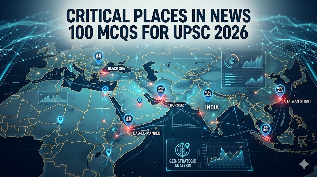
Mastering mapping is essential for the civil services examination, as several questions are directly linked to global hotspots each year. This comprehensive guide presents Places in News 100 MCQs designed for UPSC 2026 aspirants.
We have categorized these high-yield locations into ten structured sections, covering everything from maritime chokepoints like the Strait of Hormuz to disputed territories in the South China Sea. By practicing these Places in News 100 MCQs, you will develop the analytical skills required to tackle complex mapping questions in the Prelims with precision.
Section 1: Middle East and Maritime Chokepoints: Places in News 100 MCQs
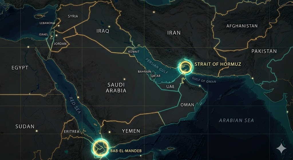
1. Consider the following statements regarding the Strait of Hormuz:
It connects the Persian Gulf with the Gulf of Aden.
It is bordered by Iran to the north and Oman’s Musandam Peninsula to the south.
Which of the statements given above is/are correct?
A) 1 only
B) 2 only
C) Both 1 and 2
D) Neither 1 nor 2
Read more about the strategic importance of the Strait of Hormuz and the Oil Crisis.”
2. Recently, ‘Chabahar Port’ was in the news. It is located on the coast of which water body?
A) Persian Gulf
B) Red Sea
C) Gulf of Oman
D) Caspian Sea
3. The ‘Bab-el-Mandeb’ strait, often called the ‘Gate of Tears’, connects:
A) Red Sea and Gulf of Aden
B) Mediterranean Sea and Red Sea
C) Persian Gulf and Gulf of Oman
D) Black Sea and Sea of Marmara
4. Which of the following countries do NOT share a border with the Dead Sea?
Jordan
Israel
Lebanon
Egypt
Select the correct answer using the code below:
A) 1 and 2
B) 3 and 4
C) 2 and 3
D) 1 and 4
5. The ‘Gaza Strip’ shares a land border with which of the following?
Israel
Egypt
Jordan
Lebanon
Select the correct code:
A) 1 and 2 only
B) 2 and 3 only
C) 1, 2 and 3
D) 1 only
6. Socotra Island, recently seen in the news due to its strategic location in the Indian Ocean, belongs to:
A) Somalia
B) Yemen
C) Oman
D) UAE
7. Arrange the following cities from North to South:
Tehran
Dubai
Riyadh
Muscat
Select the correct sequence:
A) 1-3-2-4
B) 1-2-3-4
C) 3-1-4-2
D) 1-3-4-2
8. The ‘Abraham Accords’, often discussed in international relations, primarily focus on ties between Israel and:
A) Iran and Iraq
B) UAE and Bahrain
C) Saudi Arabia and Qatar
D) Turkey and Egypt
9. Consider the ‘Ben Gurion Canal Project’. It is proposed as an alternative to:
A) Panama Canal
B) Suez Canal
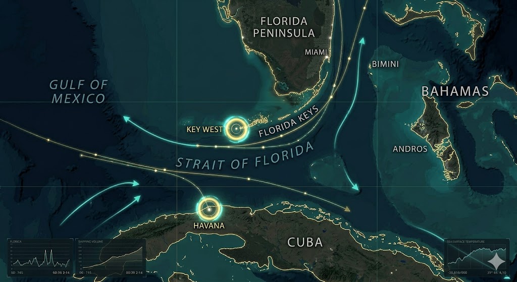
C) Strait of Malacca
D) English Channel
10. Mount Sinai, a place of historical and religious significance, is located in:
A) Israel
B) Jordan
C) Egypt (Sinai Peninsula)
D) Saudi Arabia
Explanatory Answers: Section 1
Ans: B. Statement 1 galat hai kyunki Hormuz Persian Gulf ko Gulf of Oman se jodta hai (na ki Gulf of Aden se).
Ans: C. Chabahar Iran mein hai aur Gulf of Oman par sthit hai, jo India ke liye strategically vital hai.
Ans: A. Bab-el-Mandeb Red Sea aur Gulf of Aden ko jodta hai, jo Yemen aur Djibouti ke beech hai.
Ans: B. Dead Sea sirf Jordan aur Israel ke beech sthit hai. Lebanon aur Egypt isse border share nahi karte.
Ans: A. Gaza Strip ki land borders sirf Israel (North/East) aur Egypt (South) se lagti hain.
Ans: B. Socotra Yemen ka hissa hai aur ye Gulf of Aden ke muhanay par sthit hai.
Ans: A. North to South sahi kram hai: Tehran (Iran) > Riyadh (Saudi) > Dubai (UAE) > Muscat (Oman).
Ans: B. Abraham Accords Israel, UAE aur Bahrain ke beech normalization agreements hain.
Ans: B. Ben Gurion Canal ko Suez Canal ke alternative ke roop mein dekha ja raha hai jo Israel se hokar guzrega.
Ans: C. Mount Sinai Egypt ke Sinai Peninsula ka hissa hai.
For a deeper dive into regional tensions, check out our Iran-Israel War MCQs 2026 guide.”
Section 2: Eastern Europe and the Black Sea Region: Places in News 100 MCQs
11. Consider the following countries:
Bulgaria
Georgia
Moldova
Turkey
Which of the above countries share a border with the Black Sea?
A) 1, 2 and 3 only
B) 2, 3 and 4 only
C) 1, 2 and 4 only
D) 1, 2, 3 and 4
12. The ‘Kerch Strait’ is a strategic waterway that connects:
A) Black Sea and Sea of Marmara
B) Sea of Azov and Black Sea
C) Caspian Sea and Aral Sea
D) Baltic Sea and North Sea
13. Recently seen in the news, ‘Snake Island’ (Zmiinyi Island) is located in which water body?
A) Mediterranean Sea
B) Caspian Sea
C) Black Sea
D) Adriatic Sea
14. The ‘Transnistria’ region, often described as a ‘frozen conflict’ zone, is located between:
A) Ukraine and Russia
B) Armenia and Azerbaijan
C) Moldova and Ukraine
D) Georgia and Russia
15. Consider the following pairs of Cities and Rivers:
Kyiv : Dnieper River
Warsaw : Vistula River
Budapest : Danube River
Which of the pairs given above are correctly matched?
A) 1 and 2 only
B) 2 and 3 only
C) 1 and 3 only
D) 1, 2 and 3
16. The ‘Suwalki Gap’, a strategic 100-km strip of land, is often discussed in the context of:
A) Central Asian borders
B) Border between Poland and Lithuania
C) South China Sea disputes
D) Arctic Circle exploration
17. Which of the following bodies of water is/are landlocked?
Caspian Sea
Aral Sea
Black Sea
Select the correct code:
A) 1 only
B) 1 and 2 only
C) 2 and 3 only
D) 1, 2 and 3
18. The ‘Donbas’ region, central to the Russia-Ukraine conflict, comprises which two administrative divisions?
A) Crimea and Sevastopol
B) Kharkiv and Kherson
C) Donetsk and Luhansk
D) Odessa and Mariupol
19. Kaliningrad, a Russian exclave, shares land borders with which two countries?
A) Poland and Lithuania
B) Belarus and Poland
C) Estonia and Latvia
D) Finland and Norway
20. The ‘Montreux Convention’ (1936) regulates the transit of naval warships through which straits?
A) Gibraltar and English Channel
B) Bosporus and Dardanelles
C) Malacca and Sunda
D) Hormuz and Bab-el-Mandeb
Explanatory Answers: Section 2
Ans: C. Black Sea ko border karne wale desh hain: Ukraine, Russia, Georgia, Turkey, Bulgaria, aur Romania. Moldova ek landlocked desh hai, iski border sea se nahi lagti.
Ans: B. Kerch Strait Crimea ke paas hai jo Sea of Azov ko Black Sea se jodta hai.
Ans: C. Snake Island Black Sea mein ek strategic outpost hai jo Ukraine ke control mein hai.
Ans: C. Transnistria Moldova ka ek breakaway region hai jo Moldova aur Ukraine ke border ke beech sthit hai (yahan Russian-speaking population zyada hai).
Ans: D. Teeno pairs sahi hain. Kyiv Dnieper par hai, Warsaw Vistula par, aur Budapest Danube river par sthit hai.
Ans: B. Suwalki Gap Poland aur Lithuania ke beech ka rasta hai jo Belarus ko Russia ke exclave Kaliningrad se jodta hai. Ye NATO ke liye kafi sensitive hai.
Ans: B. Caspian Sea aur Aral Sea landlocked (charon taraf zameen se gire) hain. Black Sea Mediterranean Sea se connected hai (via Bosporus).
Ans: C. Donbas region Eastern Ukraine mein Donetsk aur Luhansk oblasts (states) se milkar banta hai.
Ans: A. Kaliningrad Russia ka wo hissa hai jo main Russia se juda nahi hai; iske borders Poland aur Lithuania se lagte hain.
Ans: B. Montreux Convention Turkey ko Bosporus aur Dardanelles straits par control deta hai, jisse wo war ke waqt warships ki entry rok sakta hai.
For additional international affairs practice, solve IMEC 100 MCQs UPSC 2026: Powerful Practice Set with Most Important Questions covering one of the most important global connectivity projects.
Section 3: Central Asia and South Asia (India’s Neighborhood): Places in News 100 MCQs
21. Consider the following countries:
Kazakhstan
Turkmenistan
Uzbekistan
Afghanistan
Which of the above countries are ‘Double Landlocked’ (surrounded only by landlocked countries)?
A) 1 and 2 only
B) 3 only
C) 4 only
D) 2 and 4 only
22. The ‘Wakhan Corridor’, a narrow strip of land, connects Afghanistan with which country?
A) Tajikistan
B) Uzbekistan
C) China
D) Iran
23. Recently, ‘Lake Issyk-Kul’ was in the news. In which Central Asian country is it located?
A) Kazakhstan
B) Kyrgyzstan
C) Tajikistan
D) Turkmenistan
24. Consider the following pairs of Hydropower Projects and Rivers (South Asia):
Salma Dam (Friendship Dam) : Hari River
Arun-III Project : Koshi River
Mangdechhu Project : Manas River
Which of the pairs given above is/are correctly matched?
A) 1 only
B) 1 and 2 only
C) 2 and 3 only
D) 1, 2 and 3
25. The ‘Fergana Valley’, a region known for its complex borders and ethnic diversity, is shared by which three countries?
A) Kazakhstan, Kyrgyzstan, Uzbekistan
B) Kyrgyzstan, Tajikistan, Uzbekistan
C) Turkmenistan, Uzbekistan, Afghanistan
D) Tajikistan, Afghanistan, Pakistan
26. Which of the following water bodies has been shrinking significantly, often cited as one of the worst environmental disasters?
A) Caspian Sea
B) Aral Sea
C) Baikal Lake
D) Lake Van
27. The ‘Kalaudan Multi-Modal Transit Transport Project’ connects India’s Kolkata port with which port in Myanmar?
A) Kyaukpyu Port
B) Yangon Port
C) Sittwe Port
D) Dawei Port
28. Consider the following statements regarding ‘Chabahar Port’:
It is located in the Sistan-Baluchestan province of Iran.
It provides India an alternative route to Afghanistan bypassing Pakistan.
Which of the statements given above is/are correct?
A) 1 only
B) 2 only
C) Both 1 and 2
D) Neither 1 nor 2
29. The ‘Zojila Pass’, recently in the news for the construction of Asia’s longest bi-directional tunnel, connects:
A) Srinagar and Leh
B) Leh and Manali
C) Jammu and Srinagar
D) Shimla and Tibet
30. Which of the following Central Asian countries does NOT share a border with the Caspian Sea?
A) Kazakhstan
B) Turkmenistan
C) Uzbekistan
D) Russia
Explanatory Answers: Section 3
Ans: B. Poore world mein sirf do desh ‘Double Landlocked’ hain: Uzbekistan (Central Asia) aur Liechtenstein (Europe).
Ans: C. Wakhan Corridor Afghanistan ka wo patla hissa hai jo East mein China (Xinjiang region) se touch hota hai, Tajikistan aur Pakistan ke beech.
Ans: B. Lake Issyk-Kul Kyrgyzstan mein sthit hai. Ye duniya ki doosri sabse badi alpine lake hai.
Ans: B. Salma Dam Afghanistan mein Hari River par hai. Arun-III Nepal mein Koshi ki sahayak nadi par hai. Mangdechhu Bhutan mein Mangdechhu river par hai (na ki Manas par).
Ans: B. Fergana Valley Kyrgyzstan, Tajikistan aur Uzbekistan ke beech ek disputed aur fertile region hai.
Ans: B. Aral Sea (Uzbekistan-Kazakhstan border) irrigation ke liye nadiyon ka rasta badalne ki wajah se lagbhag sookh chuka hai.
Ans: C. Kaladan project Kolkata ko Myanmar ke Sittwe Port se jodta hai, jo Mizoram se connectivity badhayega.
Ans: C. Dono statements sahi hain. Chabahar Gulf of Oman par hai aur India ke liye strategic connectivity point hai.
Ans: A. Zojila Pass Great Himalayan Range mein hai jo Srinagar ko Leh (Ladakh) se jodta hai.
Ans: C. Uzbekistan landlocked hai aur Caspian Sea ko touch nahi karta. Caspian ko touch karne wale desh hain: Kazakhstan, Turkmenistan, Iran, Azerbaijan aur Russia (Tarikh code).
Section 4: Africa and the Mediterranean Region: Places in News 100 MCQs
31. The ‘Grand Ethiopian Renaissance Dam’ (GERD), a source of long-standing tension in Africa, is constructed on which river?
A) White Nile
B) Blue Nile
C) Congo River
D) Zambezi River
32. Consider the following pairs of Regions and Countries:
Tigray : Ethiopia
Cabo Delgado : Mozambique
Darfur : Sudan
Which of the pairs given above is/are correctly matched?
A) 1 only
B) 1 and 2 only
C) 2 and 3 only
D) 1, 2 and 3
33. The ‘Sahel Region’, often mentioned in the context of desertification and security crises, stretches across which part of Africa?
A) Southern tip of Africa
B) Northern coast along the Mediterranean
C) Transition zone between Sahara Desert and Savanna
D) East African Rift Valley
34. Which of the following countries do NOT have a coastline on the Mediterranean Sea?
Libya
Chad
Jordan
Tunisia
Select the correct code:
A) 1 and 4
B) 2 and 3
C) 3 and 4
D) 1 and 2
35. The ‘Strait of Gibraltar’ connects the Atlantic Ocean with the Mediterranean Sea and separates which two countries?
A) Spain and Morocco
B) Portugal and Morocco
C) Italy and Tunisia
D) Greece and Turkey
36. Recently, the ‘Agalega Islands’ were in the news regarding India’s maritime cooperation. These islands belong to:
A) Seychelles
B) Maldives
C) Mauritius
D) Madagascar
37. Which of the following African nations is the newest member of the BRICS grouping (as of the 2024 expansions)?
A) Nigeria
B) Ethiopia
C) Kenya
D) Morocco
38. The ‘Great Rift Valley’, a massive geological feature, primarily runs through which part of Africa?
A) West Africa
B) North Africa
C) East Africa
D) Central Africa
39. Consider the following statements regarding the ‘Red Sea’:
It is connected to the Mediterranean Sea via the Suez Canal.
It is bordered by Saudi Arabia to the east and Sudan to the west.
Which of the statements given above is/are correct?
A) 1 only
B) 2 only
C) Both 1 and 2
D) Neither 1 nor 2
40. The ‘Gulf of Guinea’, notorious for maritime piracy incidents, is located off the coast of:
A) East Africa
B) West Africa
C) North Africa
D) South Africa
Explanatory Answers: Section 4
Ans: B. GERD Ethiopia mein Blue Nile par bana hai. Iska Sudan aur Egypt ke saath paani ke batware ko lekar vivad hai.
Ans: D. Teeno sahi hain. Tigray Ethiopia ka northern region hai, Cabo Delgado Mozambique mein insurgency-hit area hai, aur Darfur Western Sudan mein hai.
Ans: C. Sahel ek semi-arid transition zone hai jo Sahara Desert (North) aur Sudanian Savanna (South) ke beech poore Africa mein faila hai.
Ans: B. Chad landlocked desh hai aur Jordan ki border sirf Red Sea (Gulf of Aqaba) se lagti hai, Mediterranean se nahi.
Ans: A. Gibraltar Strait Europe (Spain) aur Africa (Morocco) ko alag karta hai.
Ans: C. Agalega Islands Mauritius ka hissa hain, jahan India ne ek airstrip aur jetty develop ki hai strategic maritime monitoring ke liye.
Ans: B. 2024 mein Ethiopia aur Egypt BRICS ke naye African members bane thay (South Africa ke baad).
Ans: C. Great Rift Valley East Africa mein hai, jo Jordan se lekar Mozambique tak faili hui hai. Ye tectonic plates ke alag hone se bani hai.
Ans: C. Dono sahi hain. Red Sea Suez Canal ke zariye Mediterranean se judta hai aur iske borders par Saudi Arabia (East) aur Sudan/Egypt/Eritrea (West) hain.
Ans: B. Gulf of Guinea West Africa ke Atlantic coast par hai, jo Nigeria aur Ghana jaise deshon ke paas hai.
Section 5: South East Asia and the South China Sea: Places in News 100 MCQs
41. The ‘Nine-Dash Line’, frequently mentioned in the news, is a territorial claim associated with which water body?
A) East China Sea
B) South China Sea
C) Sea of Japan
D) Bay of Bengal
42. Consider the following island groups:
Paracel Islands
Spratly Islands
Scarborough Shoal
Which of the above are disputed territories in the South China Sea?
A) 1 and 2 only
B) 2 and 3 only
C) 1 and 3 only
D) 1, 2 and 3
43. The ‘Strait of Malacca’, one of the world’s busiest shipping lanes, lies between which two landmasses?
A) Malay Peninsula and Sumatra Island
B) Sumatra Island and Java Island
C) Borneo Island and Sulawesi
D) Malay Peninsula and Borneo
44. Recently, the ‘Kra Isthmus Canal’ (Thai Canal) has been proposed as a strategic alternative to bypass:
A) Sunda Strait
B) Strait of Malacca
C) Lombok Strait
D) Palk Strait
45. Which of the following countries is/are landlocked in South East Asia?
Vietnam
Laos
Cambodia
Thailand
Select the correct code:
A) 1 and 2
B) 2 only
C) 2 and 3
D) 1, 2 and 4
46. The ‘Mekong River’, often called the ‘Danube of the East’, flows through all of the following countries EXCEPT:
A) China
B) Myanmar
C) Malaysia
D) Vietnam
47. Consider the following pairs of Islands and Countries:
Natuna Islands : Indonesia
Mindanao : Philippines
Phu Quoc : Vietnam
Which of the pairs given above are correctly matched?
A) 1 and 2 only
B) 2 and 3 only
C) 1 and 3 only
D) 1, 2 and 3
48. The ‘Sunda Strait’, which connects the Java Sea to the Indian Ocean, separates which two Indonesian islands?
A) Sumatra and Java
B) Java and Bali
C) Bali and Lombok
D) Sumatra and Borneo
49. ‘Lombok Strait’ is significant for global maritime trade because:
A) It is the shallowest strait in Asia.
B) It serves as a deep-water alternative for mega-tankers that cannot fit through the Malacca Strait.
C) It is the only connection between the Red Sea and Indian Ocean.
D) It is located entirely within Australia’s territorial waters.
50. The ‘Golden Triangle’, a region known for illicit drug production, is located at the confluence of the borders of:
A) Thailand, Laos, and Myanmar
B) Vietnam, Cambodia, and Laos
C) India, Myanmar, and Bangladesh
D) Pakistan, Iran, and Afghanistan
Explanatory Answers: Section 5
Ans: B. Nine-Dash Line China ka ek controversial claim hai jo lagbhag poore South China Sea par apna haq jatata hai.
Ans: D. Teeno island groups disputed hain. Paracel (China-Vietnam), Spratly (Multiple countries), aur Scarborough Shoal (China-Philippines) ke beech tanaav ka kendra hain.
Ans: A. Malacca Strait Malaysia (Malay Peninsula) aur Indonesia (Sumatra) ke beech hai. Ye Indian Ocean ko Pacific Ocean se jodta hai.
Ans: B. Thai Canal (Kra Isthmus) agar banta hai toh ship ko Malacca Strait ka lamba chakkar nahi lagana padega, jisse India aur China dono ke liye strategic impact padega.
Ans: B. South East Asia mein Laos akela landlocked (charon taraf zameen se ghira) desh hai.
Ans: C. Mekong River China, Myanmar, Laos, Thailand, Cambodia, aur Vietnam se guzarti hai. Ye Malaysia se nahi guzarti.
Ans: D. Teeno sahi matched hain. Natuna Indonesia ka hai (jahan China se dispute hai), Mindanao Philippines ka southern island hai, aur Phu Quoc Vietnam ka famous island hai.
Ans: A. Sunda Strait Indonesia ke do bade islands Sumatra aur Java ko alag karta hai.
Ans: B. Lombok Strait (Bali aur Lombok ke beech) kafi gehra aur chauRa hai. Jo bade tankers (VLCCs) Malacca se nahi nikal paate, wo isi raste ka use karte hain.
Ans: A. Golden Triangle Thailand, Laos, aur Myanmar ke border par sthit hai. (Note: Pakistan-Iran-Afghanistan wala area ‘Golden Crescent’ kehlata hai)
“Are you finding these Places in News 100 MCQs helpful? Bookmark this page for your final Prelims 2026 revision.”
Check Out More UPSC Resources:
100 Essential Sports Current Affairs MCQs.
Science And Technology 100 MCQs for UPSC 2026
Section 6: East Asia and Oceania (Pacific Region): Places in News 100 MCQs
51. The ‘Taiwan Strait’, often a flashpoint in geopolitics, separates the island of Taiwan from which Chinese province?
A) Guangdong
B) Fujian
C) Zhejiang
D) Hainan
52. Consider the following islands:
Senkaku Islands
Kuril Islands
Takeshima (Liancourt Rocks)
Which of the above are disputed between Japan and its neighbors?
A) 1 and 2 only
B) 2 and 3 only
C) 1 and 3 only
D) 1, 2 and 4
53. The ‘Miyako Strait’, a strategic gateway for the Chinese Navy to enter the Western Pacific, lies between which two Japanese islands?
A) Honshu and Hokkaido
B) Okinawa and Miyako Island
C) Kyushu and Shikoku
D) Miyako and Ishigaki
54. Recently, the ‘Solomon Islands’ were in the news regarding a security pact. In which ocean are they located?
A) Indian Ocean
B) South Pacific Ocean
C) North Atlantic Ocean
D) Arctic Ocean
55. The ‘Line of Control’ (LoC) is to India-Pakistan, as the ’38th Parallel’ is to:
A) China and Vietnam
B) North Korea and South Korea
C) Japan and Russia
D) Australia and Papua New Guinea
56. Consider the following pairs of Port/City and Country:
Busan : South Korea
Osaka : Japan
Darwin : Australia
Which of the pairs given above are correctly matched?
A) 1 and 2 only
B) 2 and 3 only
C) 1 and 3 only
D) 1, 2 and 3
57. The ‘Great Barrier Reef’, the world’s largest coral reef system, is located off the coast of which Australian state?
A) Western Australia
B) New South Wales
C) Queensland
D) Victoria
58. Which of the following is/are ‘Polynesian’ islands?
Hawaii
Fiji
Samoa
Select the correct code:
A) 1 only
B) 1 and 3 only
C) 2 and 3 only
D) 1, 2 and 3
59. The ‘Tsushima Strait’ connects which two bodies of water?
A) Sea of Japan and East China Sea
B) Yellow Sea and South China Sea
C) Sea of Okhotsk and Pacific Ocean
D) Philippine Sea and Celebes Sea
60. ‘Bougainville’, a region that recently voted for independence in a referendum, is currently a part of:
A) Solomon Islands
B) Papua New Guinea
C) Indonesia
D) Vanuatu
To grasp the shifting diplomatic tides in this region, it is essential to monitor the official summits and joint statements released by the ASEAN Secretariat (Association of Southeast Asian Nations), which remains the central pillar of regional stability.
Explanatory Answers: Section 6
Ans: B. Taiwan Strait Taiwan ko mainland China ke Fujian province se alag karta hai.
Ans: D. Teeno disputed hain. Senkaku (Japan-China), Kuril (Japan-Russia), aur Takeshima (Japan-South Korea).
Ans: B. Miyako Strait Okinawa aur Miyako islands ke beech hai. Yeh international waters ka ek bada hissa hai jahan se Chinese warships Pacific mein nikalte hain.
Ans: B. Solomon Islands South Pacific (Oceania) mein sthit hain. Inka China ke saath security pact UPSC ke liye “Strategic Influence” ka point hai.
Ans: B. 38th Parallel North aur South Korea ke beech ki mukhya boundary line hai.
Ans: D. Teeno sahi hain. Busan South Korea ka main port hai, Osaka Japan ka industrial hub hai, aur Darwin Australia ka northern gateway hai.
Ans: C. Great Barrier Reef Australia ke North-East coast par Queensland ke paas sthit hai.
Ans: B. Hawaii aur Samoa Polynesian islands hain. Fiji Melanesian island group ka hissa hai.
Ans: A. Tsushima Strait (Korea Strait ka hissa) Sea of Japan aur East China Sea ko jodta hai.
Ans: B. Bougainville Papua New Guinea ka ek autonomous region hai jisne independence ke liye vote kiya hai.
Section 7: North & South America (Western Hemisphere): Places in News 100 MCQs
61. The ‘Lithium Triangle’, known for the world’s largest lithium reserves, includes which of the following countries?
A) Brazil, Argentina, and Chile
B) Argentina, Chile, and Bolivia
C) Chile, Peru, and Bolivia
D) Argentina, Brazil, and Peru
62. The ‘Darien Gap’, a notorious and dangerous break in the Pan-American Highway, is located between which two countries?
A) Mexico and Guatemala
B) Panama and Colombia
C) Costa Rica and Nicaragua
D) Colombia and Venezuela
63. Which of the following straits separates South America from Antarctica and is known for its rough seas?
A) Magellan Strait
B) Drake Passage
C) Cook Strait
D) Bering Strait
64. Consider the following pairs of Lakes and Regions:
Lake Titicaca : Andes Mountains (Bolivia/Peru)
Lake Superior : Boundary between USA and Canada
Lake Maracaibo : Venezuela
Which of the pairs given above are correctly matched?
A) 1 and 2 only
B) 2 and 3 only
C) 1 and 3 only
D) 1, 2 and 3
65. The ‘Strait of Florida’ connects the Gulf of Mexico with the Atlantic Ocean and separates:
A) USA and Cuba
B) Cuba and Bahamas
C) Mexico and Cuba
D) USA and Mexico
66. Which of the following is/are ‘Isthmus’ (a narrow strip of land connecting two larger landmasses)?
Isthmus of Tehuantepec
Isthmus of Panama
Isthmus of Palk
Select the correct code:
A) 2 only
B) 1 and 2 only
C) 2 and 3 only
D) 1, 2 and 3
67. The ‘Atacama Desert’, one of the driest places on Earth, is located in:
A) Northern Chile
B) Southern Argentina
C) Western Brazil
D) Northern Peru
68. ‘Essequibo Region’, recently a point of territorial dispute, is located between which two countries?
A) Venezuela and Guyana
B) Brazil and Argentina
C) Colombia and Ecuador
D) Suriname and French Guiana
69. The ‘Bering Strait’, which connects the Arctic Ocean to the Pacific Ocean, separates which two landmasses?
A) Alaska (USA) and Russia
B) Canada and Greenland
C) Norway and Svalbard
D) Russia and Japan
70. Which of the following South American countries is/are Landlocked?
Paraguay
Uruguay
Bolivia
Select the correct code:
A) 1 and 2 only
B) 1 and 3 only
C) 3 only
D) 1, 2 and 3
Explanatory Answers: Section 7
Ans: B. Lithium Triangle Argentina, Chile, aur Bolivia ke beech sthit hai. India ne haal hi mein yahan mining ke liye kaafi interest dikhaya hai.
Ans: B. Darien Gap Panama aur Colombia ke beech ka ghanā jungle hai jahan Pan-American Highway khatam ho jati hai. Ye migration ke liye news mein rehta hai.
Ans: B. Drake Passage South America ke Cape Horn aur Antarctica ke South Shetland Islands ke beech hai.
Ans: D. Teeno sahi matched hain. Titicaca duniya ki sabse unchi navigable lake hai. Superior North America ki sabse badi fresh water lake hai.
Ans: A. Strait of Florida USA (Florida) aur Cuba ko alag karta hai.
Ans: B. Tehuantepec (Mexico) aur Panama Isthmus hain. Palk ek ‘Strait’ (paani ka rasta) hai, landmass nahi.
Ans: A. Atacama Desert Chile mein sthit hai. Ye rain-shadow zone aur Cold Humboldt Current ki wajah se desert bana hai.
Ans: A. Essequibo Guyana ka hissa hai jis par Venezuela apna daawa karta hai. Is saal ye region kafi news mein raha hai.
Ans: A. Bering Strait North America (Alaska) ko Asia (Russia) se alag karta hai. International Date Line isi ke paas se guzarti hai.
Ans: B. South America mein sirf do desh landlocked hain: Paraguay aur Bolivia. Uruguay ki lambi coastline hai.
Section 8: Indian Geography (Mapping & Critical Locations): Places in News 100 MCQs
71. Consider the following pairs of Strategic Passes and States/UTs:
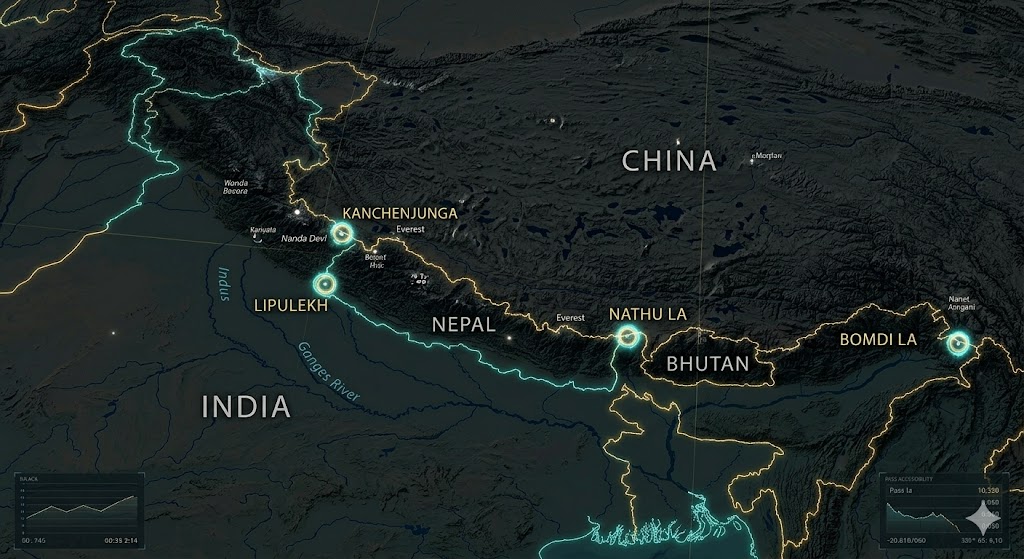
Lipulekh Pass : Uttarakhand
Nathu La : Sikkim
Banihal Pass : Ladakh
Which of the pairs given above are correctly matched?
A) 1 and 2 only
B) 2 and 3 only
C) 1 and 3 only
D) 1, 2 and 3
72. The ‘Ten Degree Channel’ separates which of the following?
A) India and Sri Lanka
B) Andaman Islands and Nicobar Islands
C) Lakshadweep and Maldives
D) North Andaman and Middle Andaman
73. Recently, ‘Mount Dhupgarh’ was in the news. It is the highest point of which mountain range?
A) Aravalli Range
B) Satpura Range
C) Vindhya Range
D) Western Ghats
74. Arrange the following Himalayan peaks from West to East:
Nanda Devi
Kanchenjunga
Mount Everest
Namcha Barwa
Select the correct sequence:
A) 1-2-3-4
B) 1-3-2-4
C) 2-1-3-4
D) 3-1-2-4
75. Which of the following rivers flows through a ‘Rift Valley’ in India?
Narmada
Tapi
Damodar
Select the correct code:
A) 1 only
B) 1 and 2 only
C) 1 and 3 only
D) 1, 2 and 3
76. The ‘Duncan Passage’ is a strait in the Indian Ocean that separates:
A) Minicoy and Maldives
B) South Andaman and Little Andaman
C) Car Nicobar and Great Nicobar
D) Rameshwaram and Jaffna
77. Consider the following statements regarding ‘Pangong Tso Lake’:
It is a saline water lake.
It is a part of the Indus River basin.
Which of the statements given above is/are correct?
A) 1 only
B) 2 only
C) Both 1 and 2
D) Neither 1 nor 2
78. Which of the following is the correct sequence of the tributaries of River Ganga from West to East?
A) Yamuna – Ghaghara – Son – Gandak – Kosi
B) Yamuna – Gandak – Ghaghara – Son – Kosi
C) Ghaghara – Yamuna – Gandak – Kosi – Son
D) Yamuna – Son – Ghaghara – Kosi – Gandak
79. The ‘Siranee/Sir Creek’ dispute is a maritime boundary issue between India and Pakistan located in:
A) Jammu and Kashmir
B) Rann of Kutch
C) Arabian Sea (off Mumbai coast)
D) Punjab border
80. ‘Eight Degree Channel’ serves as the maritime boundary between:
A) India and Indonesia
B) Andaman and Thailand
C) Lakshadweep (Minicoy) and Maldives
D) Andaman and Nicobar
Explanatory Answers: Section 8
Ans: A. Lipulekh Uttarakhand mein hai (Kailash Mansarovar route) aur Nathu La Sikkim mein. Banihal Pass Jammu aur Kashmir UT mein hai (na ki Ladakh mein).
Ans: B. Ten Degree Channel Andaman group ko Nicobar group se alag karta hai.
Ans: B. Mount Dhupgarh Pachmarhi (Madhya Pradesh) mein hai aur ye Satpura Range ki sabse unchi choti hai.
Ans: B. West to East kram hai: Nanda Devi (Uttarakhand) -> Mount Everest (Nepal) -> Kanchenjunga (Sikkim) -> Namcha Barwa (Arunachal/Tibet border).
Ans: D. Narmada, Tapi aur Damodar teeno hi rift valleys (bhramsh ghati) se hokar behti hain.
Ans: B. Duncan Passage South Andaman aur Little Andaman ke beech sthit hai.
Ans: A. Pangong Tso ek Saline (namkeen) lake hai. Statement 2 galat hai kyunki ye ek Endorheic basin hai (iska paani kisi nadi ya samundar mein nahi jaata).
Ans: A. Sahi kram (West to East): Yamuna -> Ghaghara -> Son -> Gandak -> Kosi.
Ans: B. Sir Creek Gujarat ke Rann of Kutch mein ek 96-km lamba water strip hai jo India-Pakistan ke beech disputed hai.
Ans: C. Eight Degree Channel India ke Minicoy island ko Maldives se alag karta hai.
Section 9: Arctic, Antarctic and Space-based Locations: Places in News 100 MCQs
81. India’s first permanent research station in the Arctic region is known as:
A) Dakshin Gangotri
B) Maitri
C) Himadri
D) Bharati
82. The ‘Svalbard Archipelago’, which houses the Global Seed Vault, is under the sovereignty of which country?
A) Russia
B) Norway
C) Denmark (Greenland)
D) Canada
83. Consider the following regarding Antarctica:
‘Bharati’ is India’s newest research station located at Larsemann Hills.
‘Dakshin Gangotri’ is currently being used as a supply base after being submerged in ice.
Which of the statements given above is/are correct?
A) 1 only
B) 2 only
C) Both 1 and 2
D) Neither 1 nor 2
84. The ‘Northern Sea Route’ (NSR), a potential alternative to the Suez Canal due to melting Arctic ice, primarily runs along the coast of:
A) Canada
B) Russia
C) USA (Alaska)
D) Norway
85. ‘Shiv Shakti Point’, recently named in the news, is located on:
A) The Lunar South Pole
B) Mars (near Gale Crater)
C) Andaman and Nicobar Islands
D) Antarctica (near Maitri station)
86. The ‘McMurdo Dry Valleys’, one of the most extreme deserts on Earth and often compared to the Martian surface, are located in:
A) Atacama, Chile
B) Antarctica
C) Gobi Desert
D) Sahara Desert
87. Which of the following bodies of water separates Greenland from the Canadian Arctic Archipelago?
A) Bering Strait
B) Davis Strait
C) Denmark Strait
D) Cook Strait
88. The ‘James Webb Space Telescope’ (JWST) is currently stationed at which point in space?
A) L1 (Lagrange Point 1)
B) L2 (Lagrange Point 2)
C) Low Earth Orbit (LEO)
D) Lunar Orbit
89. ‘Weddell Sea’ and ‘Ross Sea’, often discussed in the context of marine protected areas, are part of which ocean?
A) Arctic Ocean
B) Southern Ocean (Antarctic)
C) Indian Ocean
D) Pacific Ocean
90. India’s ‘Deep Ocean Mission’ aims to explore poly-metallic nodules in the ‘Central Indian Ocean Basin’. Which of the following is a primary mineral targeted?
A) Lithium
B) Manganese
C) Gold
D) Uranium
Explanatory Answers: Section 9
Ans: C. Himadri India ka pehla Arctic research station hai (Ny-Ålesund, Norway mein).
Ans: B. Svalbard Norway ka hissa hai. Yahan “Doomsday Seed Vault” sthit hai jo global disasters ke waqt seeds ko safe rakhta hai.
Ans: C. Dono sahi hain. Bharati (Larsemann Hills) aur Mitai (Schirmacher Oasis) active hain, jabki Dakshin Gangotri ab sirf ek storage/supply base hai.
Ans: B. Northern Sea Route Russia ke Arctic coast ke saath chalta hai aur Asia-Europe ke beech rasta chota kar deta hai.
Ans: A. Chandrayaan-3 ka lander jis jagah Moon par utra tha, use ‘Shiv Shakti Point’ naam diya gaya hai.
Ans: B. McMurdo Dry Valleys Antarctica mein hain. Yahan barf nahi girti aur conditions bilkul Mars jaisi hain.
Ans: B. Davis Strait Greenland aur Canada (Baffin Island) ko alag karta hai.
Ans: B. JWST Lagrange Point 2 (L2) par sthit hai, jo Earth se 1.5 million km door hai, taaki wo sun ki garmi se bacha rahe.
Ans: B. Weddell Sea aur Ross Sea Antarctica ke paas Southern Ocean ka hissa hain.
Ans: B. Deep Ocean Mission ka mukhya target Manganese (Poly-metallic nodules) hai, jisme cobalt aur copper bhi hote hain.
Section 10: Mixed Bag & Current Affairs 2025-26 Refresher: Places in News 100 MCQs
91. The ‘Durand Line’, often a source of tension and border fencing disputes, serves as the international boundary between:
A) India and Afghanistan
B) Pakistan and Afghanistan
C) Iran and Pakistan
D) India and Myanmar
92. ‘Port City Colombo’, a massive reclaimed land project, is often discussed as a part of which country’s strategic investment in South Asia?
A) India
B) China
C) USA
D) Japan
93. Consider the following pairs of Canal/Waterway and Connectivity:
Kiel Canal : North Sea and Baltic Sea
Corinth Canal : Gulf of Corinth and Saronic Gulf
Panama Canal : Atlantic Ocean and Indian Ocean
Which of the pairs given above are correctly matched?
A) 1 and 2 only
B) 2 and 3 only
C) 1 and 3 only
D) 1, 2 and 3
94. The ‘Kurile Islands’ dispute, which has prevented the signing of a formal peace treaty since WWII, involves which two nations?
A) Japan and China
B) Japan and Russia
C) South Korea and Japan
D) Russia and USA
95. Which of the following African countries is the first to have successfully launched its own satellite into space (as of recent history)?
A) South Africa
B) Egypt
C) Kenya
D) Nigeria
96. ‘Nagorno-Karabakh’, a landlocked mountainous region in the South Caucasus, is a bone of contention between:
A) Russia and Ukraine
B) Armenia and Azerbaijan
C) Georgia and Russia
D) Turkey and Greece
97. Consider the following statements regarding the ‘Arctic Council’:
India is one of the permanent members of the Arctic Council.
The council focuses on sustainable development and environmental protection in the Arctic.
Which of the statements given above is/are correct?
A) 1 only
B) 2 only
C) Both 1 and 2
D) Neither 1 nor 2
98. The ‘Dardanelles Strait’, along with the Bosporus, connects the Aegean Sea to the:
A) Black Sea
B) Sea of Marmara
C) Adriatic Sea
D) Caspian Sea
99. Which of the following is the world’s largest landlocked country by area?
A) Mongolia
B) Kazakhstan
C) Chad
D) Bolivia
100. ‘Zaporizhzhia’, often in the headlines for having Europe’s largest nuclear power plant, is located in:
A) Russia
B) Belarus
C) Ukraine
D) Poland
Explanatory Answers: Section 10
Ans: B. Durand Line Pakistan aur Afghanistan ke beech ki boundary hai. Taliban government ise puri tarah acknowledge nahi karti, jo aksar tanaav ka karan banta hai.
Ans: B. Port City Colombo Sri Lanka mein China dwara fund kiya gaya ek Special Economic Zone (reclaimed land) hai.
Ans: A. Panama Canal Atlantic aur Pacific Ocean ko jodta hai (na ki Indian Ocean ko). Baki dono pairs sahi hain.
Ans: B. Kurile Islands Japan aur Russia ke beech disputed hain.
Ans: B. Egypt (aur South Africa) Africa ke space pioneers hain. Haal hi mein Egypt ne satellite technology mein kaafi progress ki hai.
Ans: B. Nagorno-Karabakh Azerbaijan ke andar hai lekin yahan Armenia-backed population ka control raha hai, jo dono deshon ke beech yudh ka karan hai.
Ans: B. India Arctic Council ka ‘Observer’ hai, permanent member nahi. Member wahi desh hain jinki zameen Arctic circle ke andar aati hai.
Ans: B. Aegean Sea -> Dardanelles -> Sea of Marmara -> Bosporus -> Black Sea. Ye kram yaad rakhein.
Ans: B. Kazakhstan duniya ka sabse bada landlocked desh hai.
Ans: C. Zaporizhzhia Ukraine mein Dnieper river ke kinare sthit hai. Ye Europe ka sabse bada nuclear plant hai.
Conclusion: Places in News 100 MCQs
Consistent practice with these Places in News 100 MCQs will ensure you don’t miss out on easy marks in the Geography and IR sections.
2 thoughts on “Places in News 100 MCQs for UPSC 2026: Comprehensive Guide”