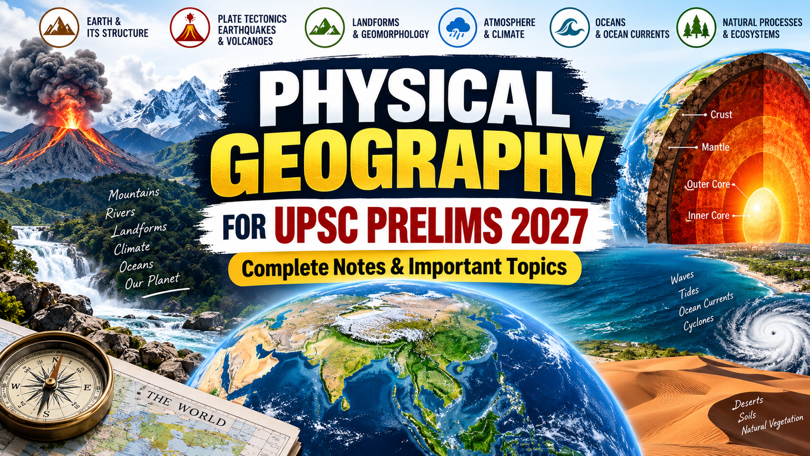
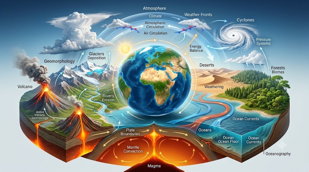
Physical Geography for UPSC Prelims 2027 is one of the most important areas of Geography preparation. It helps aspirants understand how the Earth works—from its interior and plate movements to landforms, atmosphere, climate, oceans and natural phenomena.
The key to preparing Physical Geography is conceptual clarity rather than memorising isolated facts. Once the basic processes are understood, many UPSC Prelims questions can be solved through logic, elimination and the application of concepts.
Physical Geography for UPSC Prelims 2027 is one of the most important areas of Geography preparation.
If you want to strengthen your Indian Geography preparation alongside physical concepts, read our guide on Physical Geography of India UPSC MCQs 2027
The official NCERT Class XI Geography material covers major physical-geography areas including the Earth, plate tectonics, earthquakes, volcanoes, landforms, climate, oceans, biodiversity and related processes.
Physical Geography for UPSC Prelims 2027: What to Study?
A strong foundation in Physical Geography for UPSC Prelims 2027 helps aspirants understand Earth’s physical processes.
For Physical Geography for UPSC Prelims 2027, focus on these major areas:
- Earth and its structure
- Plate tectonics
- Continental drift
- Earthquakes
- Volcanoes
- Rocks and minerals
- Geomorphic processes
- Landforms
- Weathering and erosion
- Atmosphere
- Insolation and heat budget
- Temperature and pressure
- Winds
- Air masses and fronts
- Cyclones
- Humidity and precipitation
- World climate
- Ocean relief
- Ocean temperature and salinity
- Ocean currents
- Tides and waves
- Hydrological cycle
- Biosphere and ecosystems
- Biogeochemical cycles
- Physical geography-based mapping
Earth and Its Structure
Understanding the structure of the Earth is the foundation of Physical Geography.
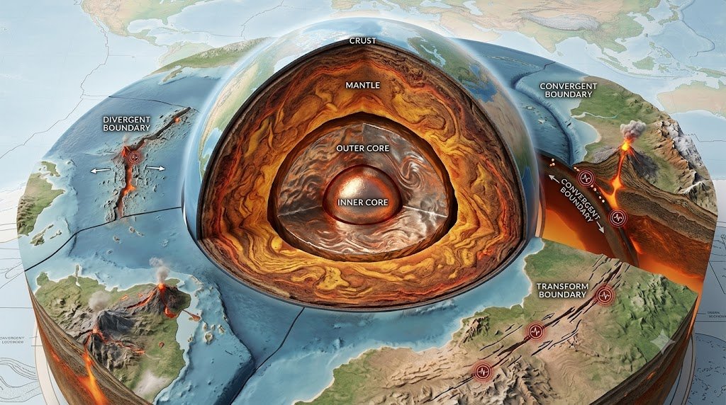
The Earth can broadly be studied through its major internal layers.
Crust
- The outermost solid layer of the Earth.
- It is relatively thin compared with the deeper layers.
- Continental crust and oceanic crust differ in composition and thickness.
Mantle
- Located below the crust.
- It extends to a much greater depth than the crust.
- Mantle processes are closely associated with plate movement and volcanism.
Core
The core is the deepest major layer of the Earth.
It is commonly divided into:
- Outer core
- Inner core
UPSC Prelims Focus
Remember the distinction between:
Crust → Mantle → Core
Also understand how seismic waves help scientists study Earth’s interior.
Plate Tectonics
Plate tectonics is one of the highest-value concepts in Physical Geography for UPSC Prelims 2027.
The Earth’s lithosphere is divided into large and small tectonic plates.
These plates move relative to one another.
Major Types of Plate Boundaries
Divergent Boundary
Two plates move away from each other.
Common outcomes:
- Rift formation
- Seafloor spreading
- Volcanic activity
Convergent Boundary
Two plates move towards each other.
Possible outcomes include:
- Mountain building
- Subduction
- Earthquakes
- Volcanism
Transform Boundary
Two plates slide past one another.
These boundaries are commonly associated with earthquakes.
Prelims Tip
Do not memorise plate boundaries only as definitions.
Understand:
Type of movement → geological process → resulting landform/event
Continental Drift
The Continental Drift Theory is associated with Alfred Wegener.
The basic idea was that the continents were once joined together and subsequently moved apart.
Key Concepts
- Earlier supercontinent
- Continental movement
- Fossil evidence
- Geological evidence
- Matching coastlines
- Similar rock formations
Later developments in Earth sciences, especially plate tectonics and seafloor spreading, provided a broader framework for understanding continental movement.
Earthquakes
An earthquake is the sudden release of energy within the Earth, producing seismic waves.
Important Terms
Focus/Hypocentre:
The point inside the Earth where the earthquake originates.
Epicentre:
The point on the Earth’s surface vertically above the focus.
Seismic Waves
Important categories include:
- P waves
- S waves
- Surface waves
P Waves
- Primary waves
- Faster than S waves
- Can travel through solids and fluids
S Waves
- Secondary waves
- Slower than P waves
- Do not travel through fluids
UPSC Prelims Focus
Questions can test:
P waves vs S waves → speed → medium → behaviour
Volcanoes
Volcanism is closely connected with Earth’s internal processes.
Major Types
- Active volcanoes
- Dormant volcanoes
- Extinct volcanoes
Volcanic Features
Important features include:
- Lava
- Magma
- Crater
- Caldera
- Volcanic cone
Why Volcanoes Matter for Prelims
UPSC can connect volcanoes with:
- Plate boundaries
- Earthquakes
- Hotspots
- Pacific Ring of Fire
- Island formation
- Geothermal energy
Rocks and Minerals
Rocks are broadly classified into three major categories.
Igneous Rocks
Formed through the cooling and solidification of magma or lava.
Examples:
- Granite
- Basalt
Sedimentary Rocks
Formed through the deposition, compaction and cementation of sediments.
Examples:
- Sandstone
- Limestone
- Shale
Metamorphic Rocks
Formed when existing rocks undergo changes due to heat, pressure or both.
Examples:
- Marble
- Slate
- Quartzite
Rock Cycle
Remember:
Magma → Igneous Rock → Weathering/Erosion → Sediments → Sedimentary Rock → Heat/Pressure → Metamorphic Rock
The cycle can continue through melting and other geological processes.
Geomorphic Processes
Geomorphic processes shape the Earth’s surface.
They can broadly be associated with:
Endogenic Processes
Processes originating from within the Earth.
Examples:
- Folding
- Faulting
- Volcanism
- Earthquakes
Exogenic Processes
Processes operating mainly at or near the Earth’s surface.
Examples:
- Weathering
- Erosion
- Transportation
- Deposition
A useful way to remember the distinction is:
Endogenic → Internal forces
Exogenic → Surface processes
Weathering
Weathering is the breakdown or decomposition of rocks at or near the Earth’s surface.
Physical Weathering
The rock breaks down without major chemical alteration.
Chemical Weathering
Minerals undergo chemical changes.
Important processes include:
- Oxidation
- Carbonation
- Hydration
- Solution
Biological Weathering
Living organisms contribute to rock breakdown.
Prelims Tip
Always distinguish:
Weathering ≠ Erosion
Weathering mainly involves breakdown in place, whereas erosion involves the removal and transportation of material.
Erosion and Deposition
Erosion involves the removal and transportation of material by agents such as:
- Running water
- Wind
- Glaciers
- Waves
Deposition occurs when transported material is laid down.
This creates numerous landforms.
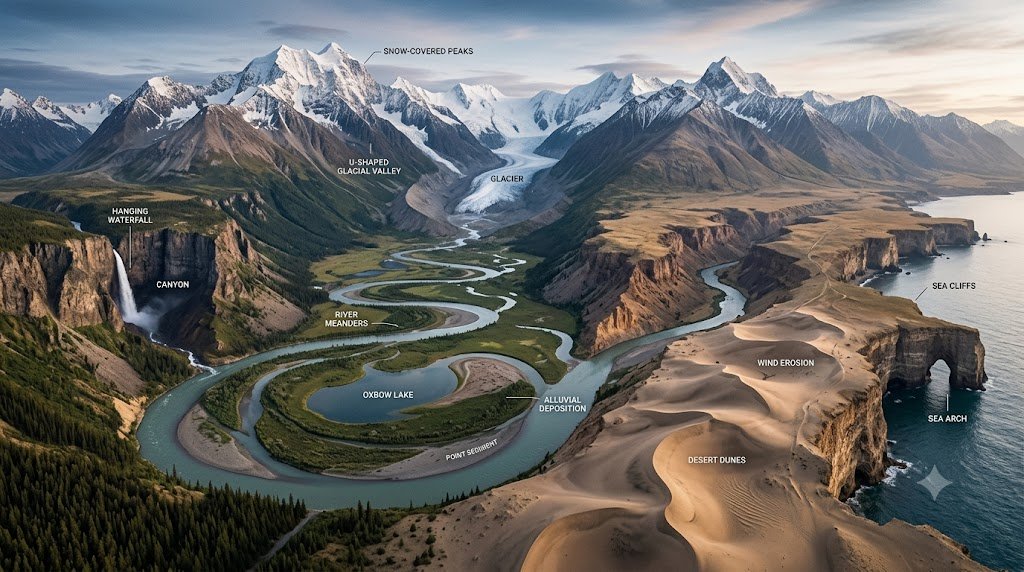
Fluvial Landforms
Rivers are powerful agents of erosion and deposition.
Erosional Features
- V-shaped valleys
- Gorges
- Canyons
- Waterfalls
- Potholes
Depositional Features
- Floodplains
- Natural levees
- Meanders
- Oxbow lakes
- Deltas
- Alluvial fans
Important Concept
The characteristics of a river change from its upper course to its lower course.
Therefore, understand:
Upper Course → Middle Course → Lower Course
rather than memorising individual landforms randomly.
Glacial Landforms
Glaciers modify landscapes through erosion and deposition.
Important Glacial Landforms
- U-shaped valleys
- Cirques
- Arêtes
- Horns
- Moraines
- Drumlins
- Eskers
Prelims Strategy
If a question mentions:
U-shaped valley → think glacial erosion
Moraine → think glacial deposition
Desert Landforms
Wind plays a major role in shaping arid landscapes.
Important features include:
- Sand dunes
- Yardangs
- Mushroom rocks
- Deflation hollows
- Loess deposits
Sand Dunes
Different wind conditions produce different dune forms.
For Prelims, focus on understanding the relationship between:
Wind direction + sediment + dune shape
Coastal Landforms
Waves, currents and tides contribute to coastal geomorphology.
Erosional Landforms
- Sea cliffs
- Sea caves
- Arches
- Stacks
- Wave-cut platforms
Depositional Landforms
- Beaches
- Spits
- Bars
- Lagoons
A common conceptual sequence is:
Cave → Arch → Stack
as coastal erosion progresses in suitable conditions.
Karst Topography
Karst landscapes are commonly associated with soluble rocks, particularly limestone.
Important features include:
- Sinkholes
- Caves
- Caverns
- Stalactites
- Stalagmites
- Underground drainage
Easy Memory Aid
Stalactite → hangs from the ceiling
Stalagmite → rises from the ground
Atmosphere
The atmosphere is essential for understanding weather and climate.
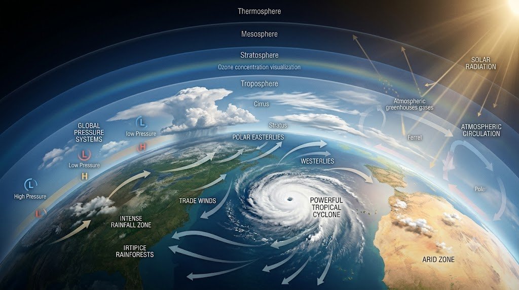
Major atmospheric layers include:
- Troposphere
- Stratosphere
- Mesosphere
- Thermosphere
- Exosphere
Troposphere
- Lowest major atmospheric layer.
- Most weather phenomena occur here.
Stratosphere
- Located above the troposphere.
- Contains the ozone layer.
Prelims Focus
Know the:
Layer → altitude relationship → important phenomenon
Insolation
Insolation means incoming solar radiation received by the Earth.
The amount of solar energy received varies because of factors such as:
- Latitude
- Angle of incidence
- Duration of sunshine
- Atmospheric conditions
- Season
Key Concept
The Earth’s surface does not receive solar energy uniformly.
This unequal heating contributes to atmospheric circulation and climate differences.
Heat Budget of the Earth
The Earth receives energy from the Sun and loses energy back to space.
The balance between incoming and outgoing energy is known as the Earth’s heat budget.
Understanding the heat budget helps explain:
- Temperature differences
- Atmospheric circulation
- Pressure differences
- Winds
- Climate patterns
Temperature
Temperature varies spatially and vertically.
Important factors include:
- Latitude
- Altitude
- Distance from sea
- Ocean currents
- Winds
- Slope and aspect
- Cloud cover
Temperature Inversion
Normally, temperature decreases with altitude in the troposphere.
During an inversion, temperature increases with altitude over a certain layer.
This can influence:
- Air pollution
- Fog
- Atmospheric stability
Atmospheric Pressure
Atmospheric pressure is the force exerted by the weight of the atmosphere.
Major pressure belts include:
- Equatorial low-pressure belt
- Subtropical high-pressure belts
- Subpolar low-pressure belts
- Polar high-pressure belts
These pressure belts are fundamental to understanding global wind circulation.
Planetary Winds
Important global wind systems include:
Trade Winds
Generally associated with movement from subtropical high-pressure regions toward the equatorial low-pressure belt.
Westerlies
Generally dominant in the middle latitudes.
Polar Easterlies
Associated with the high-pressure regions around the poles.
Prelims Tip
Learn the relationship:
Pressure Belt → Direction of Wind → Latitude
Local Winds
Local winds occur under specific regional conditions.
Examples include:
- Land breeze
- Sea breeze
- Mountain breeze
- Valley breeze
Understanding differential heating of land and water is important for explaining these systems.
Air Masses and Fronts
An air mass is a large body of air with relatively uniform temperature and moisture characteristics.
When different air masses meet, a front may develop.
Important types include:
- Warm front
- Cold front
- Stationary front
- Occluded front
These concepts are important for understanding mid-latitude weather systems.
Tropical Cyclones
Tropical cyclones are intense low-pressure systems that develop under suitable oceanic and atmospheric conditions.
General Conditions
They generally require:
- Warm ocean water
- Moist atmosphere
- A pre-existing disturbance
- Sufficient Coriolis force
- Low vertical wind shear
Important Concept
Tropical cyclones generally do not develop right at the Equator because the Coriolis effect is too weak there.
Temperate Cyclones
Temperate or extra-tropical cyclones are associated with middle and higher latitudes.
They commonly develop along fronts where contrasting air masses meet.
Compare
Tropical Cyclone → warm-core system, tropical regions
Temperate Cyclone → associated with fronts, middle/high latitudes
Understanding the contrast is more useful than memorising isolated characteristics.
Humidity and Precipitation
Humidity
Humidity refers to the amount of water vapour present in the atmosphere.
Important terms include:
- Absolute humidity
- Relative humidity
- Dew point
Precipitation
Major forms include:
- Rain
- Snow
- Sleet
- Hail
Types of Rainfall
Three major mechanisms are especially important.
Convectional Rainfall
Caused by strong heating and rising moist air.
Orographic Rainfall
Occurs when moist air is forced to rise over mountains.
This can create:
Windward side → wetter
Leeward side → rain-shadow conditions
Cyclonic/Frontal Rainfall
Associated with rising air in weather systems and fronts.
World Climate
Climate classification helps explain the distribution of temperature and precipitation around the world.
For Prelims, focus on:
- Equatorial climate
- Tropical climate
- Desert climate
- Mediterranean climate
- Temperate climates
- Polar climates
- Mountain climates
Understand each through:
Temperature + Rainfall + Vegetation + Location
El Niño and La Niña
These are important ocean-atmosphere phenomena associated with the tropical Pacific Ocean.
El Niño
Broadly associated with unusual warming of central/eastern tropical Pacific waters.
Possible global effects include changes in:
- Rainfall
- Temperature
- Atmospheric circulation
La Niña
Broadly associated with unusual cooling of central/eastern tropical Pacific waters.
UPSC Connection
Link these concepts with:
- Indian monsoon
- Agriculture
- Drought
- Flooding
- Global climate patterns
Oceanography
The oceans are an important component of Physical Geography.
Major areas include:
- Ocean floor
- Ocean temperature
- Salinity
- Waves
- Tides
- Ocean currents
NCERT’s Physical Geography syllabus specifically includes the hydrological cycle, submarine relief, temperature and salinity, waves, tides and ocean currents.
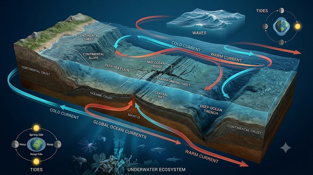
Relief of the Ocean Floor
Major divisions include:
- Continental shelf
- Continental slope
- Deep-sea plain
- Oceanic deeps
Other important features include:
- Mid-ocean ridges
- Trenches
- Seamounts
- Guyots
- Submarine canyons
Continental Shelf
It is the relatively shallow submerged extension of a continent.
Continental shelves are economically important because they can contain:
- Fisheries
- Petroleum resources
- Natural gas
- Other marine resources
Ocean Temperature
Ocean temperature varies with:
- Latitude
- Depth
- Ocean currents
- Winds
- Seasonal changes
Generally, surface waters show greater temperature variation than deep waters.
Ocean Salinity
Salinity refers to the concentration of dissolved salts in seawater.
It is influenced by:
- Evaporation
- Precipitation
- River discharge
- Freezing and melting of ice
- Ocean circulation
Prelims Approach
Always think:
More evaporation → generally higher salinity
More freshwater input → generally lower salinity
But regional conditions matter.
Ocean Currents
Ocean currents are large-scale movements of seawater.
They influence:
- Coastal climate
- Fisheries
- Navigation
- Marine ecosystems
Warm Currents
Generally transport warm water toward higher latitudes.
Cold Currents
Generally transport cooler water toward lower latitudes.
UPSC Prelims Connection
Learn currents together with their:
Origin → direction → temperature → nearby coast → climatic influence
Tides
Tides are periodic rises and falls in sea level.
They are primarily associated with the gravitational influence of:
- Moon
- Sun
Spring Tides
Occur when the Sun, Earth and Moon are aligned in suitable configurations.
Neap Tides
Occur when the Sun and Moon exert their gravitational influences from approximately perpendicular directions relative to Earth.
Waves
Waves involve the transfer of energy through ocean water.
They can be generated by:
- Wind
- Seismic disturbances
- Other forces
Tsunami
A tsunami is a series of long-wavelength sea waves usually generated by major disturbances such as undersea earthquakes, volcanic activity or submarine landslides.
Hydrological Cycle
The water cycle describes the continuous movement of water between:
- Oceans
- Atmosphere
- Land
- Groundwater
- Ice
- Living organisms
Major processes include:
Evaporation → Condensation → Precipitation → Runoff/Infiltration → Return to water bodies
NCERT identifies evaporation, evapotranspiration, sublimation, condensation, precipitation, runoff, infiltration and groundwater movement among the processes and components of the water cycle.
Biosphere and Ecosystems
Physical Geography also overlaps with ecology.
Important concepts include:
- Biosphere
- Ecosystem
- Food chain
- Food web
- Energy flow
- Biogeochemical cycles
- Ecological balance
- Biodiversity
This overlap is particularly useful because UPSC can combine Geography + Environment in a single question.
Biogeochemical Cycles
Important cycles include:
Water Cycle
Movement of water through the Earth’s systems.
Carbon Cycle
Movement of carbon between atmosphere, oceans, soil, rocks and living organisms.
Nitrogen Cycle
Movement and transformation of nitrogen through ecosystems and the atmosphere.
Phosphorus Cycle
Movement of phosphorus mainly through rocks, soil, water and living organisms.
Physical Geography and Mapping
Do not study Physical Geography without maps.
Create maps for:
- Major mountain ranges
- Plate boundaries
- Volcanoes
- Earthquake zones
- Ocean currents
- Major deserts
- Important rivers
- Climatic regions
- Major ocean trenches
- Important islands
- Straits and seas
Simple Rule
Whenever you study a geographical phenomenon, ask:
“Where is it located?”
This habit can significantly improve Prelims preparation.
How UPSC Prelims Can Test Physical Geography
Questions may be framed around:
Conceptual Questions
Example:
Which process is primarily responsible for the formation of a particular landform?
Statement-Based Questions
Several statements may be given about:
- Ocean currents
- Plate boundaries
- Cyclones
- Rocks
- Atmospheric circulation
Match-the-Following
For example:
Landform → Process
or
Current → Ocean
Map-Based Questions
You may be asked to identify:
- Mountains
- Seas
- Islands
- Straits
- Rivers
- Volcanoes
Therefore, concept + map + application is the best preparation combination.
Physical Geography for UPSC Prelims 2027: High-Priority Topics
If your preparation time is limited, prioritise these areas:
Very High Priority
- Plate Tectonics
- Earthquakes
- Volcanoes
- Geomorphic Processes
- Major Landforms
- Atmospheric Circulation
- Cyclones
- Monsoon-related concepts
- Ocean Currents
- El Niño and La Niña
High Priority
- Rocks
- Weathering
- Climate Classification
- Ocean Salinity
- Ocean Temperature
- Tides
- Waves
- Hydrological Cycle
- Atmospheric Pressure
- Air Masses and Fronts
Map-Based Revision
- Plate boundaries
- Volcano belts
- Earthquake zones
- Major mountain ranges
- Ocean currents
- Deserts
- Straits
- Trenches
- Islands
- Important physical features in the news
How to Prepare Physical Geography for UPSC Prelims 2027
Step 1: Build the Conceptual Base
Start with NCERT Physical Geography.
NCERT provides the Class XI Fundamentals of Physical Geography textbook and chapter-wise material on its official textbook portal.
Step 2: Create Short Notes
For every topic, write:
Definition → Process → Factors → Examples → Map Connection
Step 3: Use Diagrams
Draw simple diagrams for:
- Plate boundaries
- Earth’s interior
- Rock cycle
- Pressure belts
- Planetary winds
- Cyclones
- Ocean currents
- Hydrological cycle
Step 4: Practise Maps
Spend a few minutes regularly locating important geographical features.
Step 5: Solve PYQs
UPSC’s official website provides previous question papers, including Civil Services Preliminary Examination papers.
Step 6: Connect with Current Affairs
Whenever a geographical location appears in the news, locate it on the map and revise its physical characteristics.
Physical Geography Revision Formula
Use this simple formula:
Concept → Process → Example → Map → PYQ → Revision
For example:
Plate Tectonics
↓
Plate movement
↓
Earthquakes/Volcanoes/Mountains
↓
Locate major plate boundaries
↓
Solve PYQs
↓
Revise
This is far more effective than reading the same chapter repeatedly.
Common Mistakes in Physical Geography Preparation
1. Memorising Without Understanding
Physical Geography is process-oriented.
Better: Understand the cause-and-effect relationship.
2. Ignoring Maps
A geographical fact becomes much easier to remember when you know its location.
3. Studying Only Indian Geography
For Prelims, world physical geography is also important.
4. Ignoring Oceanography
Ocean currents, tides, salinity and marine geography can produce conceptual questions.
5. Not Connecting Geography with Current Affairs
Locations appearing in recent events can become useful revision points.
6. Ignoring PYQs
Previous questions help identify UPSC’s preferred style of conceptual testing.
Quick Revision Table
| Topic | What to Remember |
|---|---|
| Earth’s Interior | Crust, Mantle, Core |
| Plate Tectonics | Plate movement and boundaries |
| Earthquakes | Focus, epicentre, seismic waves |
| Volcanoes | Types, processes and distribution |
| Rocks | Igneous, Sedimentary, Metamorphic |
| Geomorphology | Internal and external processes |
| Weathering | Physical, chemical, biological |
| Rivers | Erosion, transportation, deposition |
| Glaciers | Erosional and depositional landforms |
| Deserts | Wind erosion and deposition |
| Coasts | Wave erosion and deposition |
| Atmosphere | Layers and characteristics |
| Insolation | Solar energy received by Earth |
| Pressure | Global pressure belts |
| Winds | Planetary and local winds |
| Cyclones | Tropical and temperate systems |
| Climate | Temperature and rainfall patterns |
| Oceans | Relief, temperature and salinity |
| Currents | Warm/cold currents and effects |
| Tides | Gravitational forces |
| Hydrological Cycle | Movement of water |
| Biosphere | Ecosystems and biodiversity |
Quick Revision Strategy Before UPSC Prelims 2027
First Revision
Focus on concepts and diagrams.
Second Revision
Focus on landforms, processes and comparisons.
Third Revision
Focus on maps and locations.
Fourth Revision
Focus on PYQs and statement-based questions.
Final Revision
Revise only:
- Short notes
- Diagrams
- Maps
- Important comparisons
- Frequently confused concepts
- Current geographical locations
Recommended Posts
- Indian Rivers and Drainage System UPSC Prelims 2027: Important Facts for Success
- Ultimate Physical Geography of India UPSC MCQs 2027 | 100 Important Questions With Answers
- Himalayan Rivers UPSC Prelims 2027: 100 Outstanding MCQs with Answers & Explanations
Most Important Resources for UPSC Prelims 2027
- Current Affairs For UPSC Prelims 2027
- Polity for UPSC Prelims 2027
- Economy for UPSC Prelims 2027
- History for UPSC Prelims 2027
- Science and Technology for UPSC Prelims 2027
- Geography for UPSC Prelims 2027
Physical Geography for UPSC Prelims 2027: Final Takeaway
Physical Geography becomes much easier when you stop treating it as a collection of facts.
Think in terms of processes and relationships:
Earth’s Interior → Plate Movement → Earthquakes/Volcanoes
Solar Energy → Temperature → Pressure → Winds → Weather
Water Movement → Rivers/Oceans → Landforms → Climate
Ocean Temperature + Winds + Atmospheric Circulation → Global Climate Patterns
For Physical Geography for UPSC Prelims 2027, build your preparation around conceptual clarity, maps, diagrams, PYQs and current geographical developments. NCERT remains an important foundation, while the official UPSC previous papers are useful for understanding how concepts are tested.
These resources can be studied together to create a structured Geography for UPSC Prelims 2027 preparation plan.
2 thoughts on “Physical Geography for UPSC Prelims 2027: Complete Notes & Important Topics”